Drone Photogrammetry Software Services
Introduction
Our standard photogrammetry data services, LiDAR data services, and DirtMate data services are described below, as well as terminology, criteria, standards, and limitations for data accepted and produced by Propeller. Services not explicitly defined herein are subject to a separate scoping process and terms of service.
Photogrammetry Data Services Description – Current Pricing
Product Specifications
Annual Platform Access
The Annual Platform Plan includes:
- 30 “Bring Your Own Data” (BYOD) Credits that expire after 12 months (see chart below for specifications). This includes uploads in the form of Digital Elevation Model (DEM) + Orthomosaic, LAS or LAZ.
- 40 annual standard users
- 4 TB storage
- No restrictions are applied to users or storage during the first full year as a Propeller customer, thereafter customers may purchase additional users or storage at each annual renewal.
- Additional credits can be purchased in packs of 15, 30, 55, or 110 Credits and have the same specifications in the chart below.
| Included BYOD Pack | |
| Credits | 30 credits |
| Pre-processed Data per Credit | 4 gigapixels (GP) |
| Max Pre-processed Data per Upload | 40 GP |
| Point Cloud per Credit | 100M points |
| Max Point Cloud per Upload | 1B points |
| Number of Sites | Unlimited |
What other data can be uploaded?
The following data can be uploaded to your platform instance. It counts towards your overall storage usage.
Design Surfaces and Spatial Overlays:
- Design surfaces (georeferenced PDF, DXF, TTM, IFC, KML, KMZ or LandXML (CgPoints and Surfaces only))
- Maximum file size is 500MB and 300 MB for IFC files.
- 3DFACE or MESH surface layers containing more than 1,000,000 faces will not be displayed and cannot be used for measurement purposes.
- Linework (KML, KMZ, DXF)
- For linework, files less than 2MB display better in the platform.
- Keep individual file sizes below 20MB.
- Georeferenced elevation models (DEM GeoTIFF).
- Customers are able to upload any of the surfaces or overlays above as desired but will be held to the 4TB storage limit per platform license.
File Storage:
The following files are counted towards storage availability:
- Survey data files: all source photos, tiling data outputs, all files generated through Propeller that are visible in the files modal.
- Design files: all design files uploaded to Propeller.
- Media: all media files uploaded to Propeller.
- 4TB total storage available per portal.
Data Processing Packs
Annual Processing Pack
Customers may choose from the list of Credit Packs or Unlimited Packs in the chart below. Additional processing packs may be purchased without incurring an additional annual platform plan.
Annual Processing Pack Comparison
| Pack Type | Credit Pack | Unlimited Pack – 40 gigapixels (GP) per upload limit | Unlimited Pack – 70 GP per upload limit | Unlimited Pack – 100 GP per upload limit | Unlimited Pack – 217 GP per upload limit |
| Credits | Usually 15, 30, 55, or 110 | Unlimited | Unlimited | Unlimited | Unlimited |
| Drones | Unlimited | 1 | 1 | 1 | 1 |
| Gigapixels (GP) per Credit | 20 GP | – | – | – | – |
| Max GP per Upload | 200 GP | 40 GP | 70 GP | 100 GP | 217 GP |
| Ground Control Points (GCP) per Credit | 40 GCP | – | – | – | – |
| Max GCP per Upload | 400 GCP | 80 GCP | 80 GCP | 80 GCP | 80 GCP |
| Check-points | Unlimited (fair usage up to 2,400 applies) | Unlimited (fair usage up to 2,400 applies) | Unlimited (fair usage up to 2,400 applies) | Unlimited (fair usage up to 2,400 applies) | Unlimited (fair usage up to 2,400 applies) |
| Point Cloud per Credit | 100M points | – | – | – | – |
| Max Point Cloud per Upload | 1B points | 300M points | 300M points | 300M points | 300M points |
| Number of Sites | Unlimited | Unlimited | Unlimited | Unlimited | Unlimited |
Processing Pack Type Details
- Each image:
- Must be at least 8 megapixels.
- Must be geotagged.
- Must have a filename with fewer than 255 characters.
- Should have less than 30mm of motion blur, otherwise, the effectiveness of stitching images is reduced leading to low accuracy in the final model.
- Must have an acceptable aspect ratio and ISO for your camera’s specifications.
- Each upload:
- Must be one contiguous area. This is to avoid excessively long processing times and ensure accuracy in the resulting 3D model.
- Must have at least 10 images with the same aspect ratio.
Credit Pack Details
- Additional Credits will be charged for:
- Each additional GP over the stated credit limit in blocks of 20 GP per additional credit.
- Each additional 40 GCP over the stated limit.
Unlimited Pack Details
- If you attempt to upload a dataset that is more than your allotted gigapixel maximum you can:
- Use composite surveys.
- Purchase a credit pack.
- Upgrade to a higher gigapixel limit pack.
- Propeller’s systems automatically restrict your uploads to the single drone device you have registered to the license. Certain packs restrict usage to recommended drones only. If you’re unsure of your purchase, contact your Account Manager.
- Replacing your drone:
- Propeller will provide a method for limited self-service temporary drone replacements.
- If you replace your drone or drone’s camera device, you will need to contact Propeller support to update your license.
- When you add new drones, contact your Account Manager to discuss additional licenses.
“Bring Your Own Data” (BYOD) Pack Details
- A pre-processed credit is defined as an output from your photogrammetry processing solution or other survey data sources in GeoTIFF format.
- The site must be in a projected system, and the upload must match the site CRS. Pre-processed data in WGS84 GeoTIFF cannot be updated into published or local sites. However, if you have existing WGS84 GeoTIFF assets and need to import this historical data into the platform, please reach out to our Sales Engineers so that we can assist you with the transition process.
Requirements:
- One digital elevation model (DEM) and/or one orthophoto GeoTIFF file.
- GeoTIFF files should have unique names if you upload more than one to the platform.
- Your orthomosaic should be 4 bands RGB+Alpha (instead of 5 bands).
- DEM should have a 32-bit floating-point sampling. An integer sampling creates a stepped elevation phenomenon across the model, making it unreliable.
- 8-bit color channels
Pre-Processed Credit Sizes:
Standard pre-processed Credit size: 4,000 megapixels, referring to the resolution of the GeoTIFF files uploaded.
- For clarity, this includes GeoTIFFs with dimensions of just over 63,000 x 63,000 pixels height and width; or 40,000 x 100,000, or 10,000 x 400,000.
- You can upload a matching orthophoto (colored RGBA) image and a DEM (greyscale) image together. The limit applies to the larger file of the pair.
- Pixels are counted regardless of their transparency.
Expiration and Data Retention
Dataset Credit Expiration:
- At the end of the term determined in their contract, customers will lose access to the platform unless they have renewed their subscription.
- Unused dataset credits, including oversized surveys purchased within the platform, will expire and no longer be usable at the end of the term.
- Dataset credits do not roll over into the next term.
- Dataset credits cannot be exchanged for refund or discount.
Platform Data Retention:
- As a platform user, you can delete data that you no longer need or is no longer relevant to your project. Once deleted, the data is irrecoverable.
- If you let your platform license expire, your data will be deleted permanently after 14 days, unless you renew your license before then or purchase paid hosting. After 14 days, your data is irrecoverable, even if you do eventually renew.
- Click to read more about our Data Retention Policy.
AeroPoint Survey Data Retention:
- If you let your AeroPoint subscription expire, you will still be able to access and download all AeroPoint surveys that were processed before the subscription expired.
- AeroPoint surveys that are uploaded while the AeroPoint subscription is expired will be blocked from processing or downloading until the subscription is resumed.
Hardware-only Customer License Types
Annual AeroPoint Processing Subscription
- To process the data from AeroPoints, hardware-only customers must maintain the annual AeroPoint subscription, which is included with the purchase of new AeroPoints for the first 12 months.
- Subscription covers:
- AeroPoints simple user workflow, including hotspot uploading.
- The AeroPoints Dashboard provides multiple outputs, including processing reports and battery health.
- The ability to process coordinate data in multiple methods: Propeller Correction Network, user supplied known point method, and user supplied RINEX file.
- Simple processing in public grids.
- The hosting, permission-based sharing and organization of data over time.
- Any active software license or Annual Propeller PPK subscription includes the AeroPoints subscription.
- More information about this subscription can be found here.
Annual Propeller PPK subscription
- To process the PPK-geotagged images, hardware-only customers must maintain the annual Propeller PPK subscription.
- Photos are processed with high accuracy geotags, and the data can only be processed with AeroPoints and supported by Propeller PPK solution drones.
- This subscription covers:
- The Propeller PPK algorithm and AeroPoints simple user workflow, including hotspot uploading.
- The web-based software service that enables PPK tagging of images.
- The AeroPoints Dashboard, which provides multiple outputs, including processing reports and battery health.
- The ability to process coordinate data in multiple methods: Propeller Correction Network, user supplied known point method, and user supplied RINEX file.
- Simple processing in public grids.
- The hosting, permission-based sharing, and organization of data over time.
- Any software license includes PPK and AeroPoints processing.
- More information about this subscription can be found here.
Limitations
Certain limitations apply to hardware-only customers, including but not limited to:
- AeroPoint groups can only contain a maximum of 20 AeroPoints.
- Customer support via phone is not available.
- Customer support may take up to one business day to respond.
- AeroPoint corrections data may take up to 24 hours to retrieve.
Supported UAS and Coordinate Systems
Drones and Camera Systems
PPK-enabled Drones:
PPK-enabled drones have specifically been selected for optimization with Propeller PPK and will provide the best user experience.
- DJI Matrice 4 Enterprise
- DJI Mavic 3 Enterprise
- DJI Phantom 4 RTK
- WingtraOne Gen I / Gen II with Map61, RGB61, Sony a6100, Sony RX1R II
- WingtraRAY with Map61, Survey61, Survey24
- DJI M300/M350 with Zenmuse P1/L1/L2
- DJI M400 with Zenmuse P1/L2/L3
- Quantum Trinity F90+
- Anzu Raptor
- Autel Evo II Pro RTK V1/V2
- Autel Evo II Pro RTK V3
- Skydio X10
-
Freefly Astro
Platform Compatible Drones:
Below drones are compatible with the Propeller Platform, but may have limited functionality and will not support the complete PPK solution.
- DJI Phantom 4 Pro
- DJI Phantom 4 Pro V2
- DJI Zenmuse X7 – Matrice 210 RTK V2
- SenseFly S.O.D.A – Ebee
- SenseFly Aeria X – Ebee
See all compatible and PPK-enabled drones here.
Drone Support:
- Full support and training on data capture and upload (DJI P4RTK, DJI M300/M350 with Zenmuse P1/L1/L2, DJI M400 with Zenmuse 1/L2/L3, DJI M4E, DJI M3E, DJI P4P).
- Support for data upload only (Wingtra, Quantum, Anzu Raptor, Autel Evo II Pro RTK V1/V2, Autel Evo II Pro RTK V3).
Propeller PPK
- For hardware-only customers, Propeller PPK requires a subscription to annual corrections.
- When uploading imagery captured with drones that are compatible for use with Propeller PPK, each upload must include the following file types:
- DJI: BIN/RTK and MRK.
- Wingtra: SBF and JSON. Include only the original FlightName WingtraOne.SBF and FlightName.JSON files. Geotagging within WingtraHub will result in additional SBF and JSON files, do not upload these to the platform.
- Quantum: UBX and PROP.
- Each drone flight must be captured completely within the duration of the corresponding AeroPoint survey.
User Supplied RINEX Data
RINEX data can be self supplied for processing. This is the list of all compatible antenna types.
AeroPoint Surveys:
- AeroPoint surveys can be processed using the RINEX Upload Method, which uses the user supplied data to process AeroPoint coordinates.
PPK Surveys:
- While the Propeller Corrections Network is the simplest way to process a PPK survey, you can process PPK data with RINEX data.
In both of these cases, the accuracy of the final model will depend on the accuracy of the supplied RINEX file.
Coordinate Reference Systems (CRS)
Typically Continuously Operating Reference Stations (CORS) publish the data in 24 hours and store them for a certain period – generally 30 days or less for the majority of networks. Some store longer term, but they reduce the quality after 30 days.
If a base station has no available data for 12 hours, we will manually check and fetch data from other nearby stations if they exist, which may delay the process. After the 12 hour mark, we will use any in-range base station data, rather than wait for the closest.
Supported CRS :
- Many ellipsoid and geoid datums, and many published projected systems.
- Most JXL and GC3 local calibrations.
Propeller Corrections Network (PCN) allows users to have their AeroPoints processed and corrected without the need for local ground control markings to be made.
To use PCN on your site:
- The site needs to be within range of a PCN base station (check this map).
- The station needs to provide data in a compatible CRS.
To definitively find out whether your desired setup is supported, please contact us.
Data Processing
Propeller Processing Methods
Each survey dataset uploaded to Propeller is transformed into a 3D site model by our processing engine, using our proprietary algorithms and photogrammetric tools.
We support the processing of survey datasets:
- With or without GCPs (AeroPoints and/or custom GCPs).
- Submitted with standard accuracy or high accuracy (PPK or RTK) geotags.
- Using the Propeller PPK solution.
Propeller PPK:
Photos are processed with high accuracy geotags, and the data can be processed with / without customer GCPs and AeroPoints.
- PPK geotags can be processed using the following methods:
- Propeller Correction Network (PCN)
- Known Point (Global Site Survey Benchmark)
- Known Point (Local Site Survey Benchmark)
- User supplied RINEX
- For the Known Point methods, if the PCN is available, it may be used automatically to help increase the quality of the geotags.
- For more details on Propeller PPK, please visit our Knowledge Base.
Non-Propeller PPK:
Photos can be standard accuracy or other high accuracy (PPK or RTK) geotags. The data can be processed with or without customer GCPs and/or AeroPoints.
- AeroPoints can be processed using the following methods:
- Propeller Correction Network (PCN)
- Known Point (Global Site Survey Benchmark)
- Known Point (Local Site Survey Benchmark)
- User supplied RINEX
- Unreferenced (Unreferenced uses coarse GNSS locations and only provides relative accuracy)
- Customer GCPs
- Without GCPs
Downsampling
We typically downsample dense cloud data by 1:4 during processing. Our testing has shown that this reliably provides accurate results when best data capture practices are followed.
For example, if the captured GSD was 2 cm/pixel, the downsampled dense cloud will be 8 cm/pixel. This allows us to reduce processing time for large datasets, and we perform further downsampling for very large datasets. Here are our thresholds for downsampling when building the dense cloud:
- They are based on the total number of pixels in the source photos, measured in gigapixels (GP).
- They have been designed to rarely be used. Between January 1, 2021 and May 17, 2021, less than 2% of surveys exceed any of these thresholds.
| Thresholds for each pack type | Results | ||||
| Downsampling when an upload exceeds the relevant threshold | Credit packs | Unlimited Packs | DEM GSD compared to what was captured | Point cloud density compared to what’s possible to reconstruct | |
| 1:8 | 60 GP | 90 GP | 8 x | 1/64 x | |
| 1:16 | 120 GP | 180 GP | 16 x | 1/256 x | |
If you need to avoid heavy downsampling, you can survey the same area and stay underneath these thresholds by:
- Flying higher with less overlap.
- Subdividing the survey into smaller areas for processing and creating a composite afterwards.
Standard Processing & Delivery Timeframe
Expected Processing Times:
Photogrammetry surveys captured using the Propeller PPK with AeroPoints workflow, one of our recommended drones, and our best practices can expect faster processing times.
The following is a chart that shows the average photogrammetry survey processing times for our fastest top 10 and top 25 customers. The data is grouped by upload size to indicate how quickly surveys can be processed when using best practices.
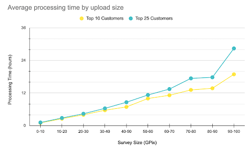
The above chart averages processing data from surveys uploaded
between August 11, 2024 to January 31, 2025. Customers have uploaded
a minimum of 12 surveys per year to be included.
Factors that Extend Processing Time or Delay Delivery
- Your data requires manual fixes due to non-ideal or unrecommended collection methods.
- If your AeroPoints corrections data is delayed. Processing can only begin once the corrections data is available. For urgent jobs, use the Known Point Method.
- User input errors at upload (incorrect information, incomplete files, etc.).
- Ground control point (GCP) identification errors or missing GCPs.
- Corrupt images or photo geotags.
- Lengthy delays responding to processing questions or clarifications requested by Propeller staff.
- Using non-standard outputs, such as tiled models (vertical face imagery).
The following are the processing and delivery timeframes we uphold when processing your survey data. Our commitment is to meet these timeframes for at least 90% of all uploads. For your dataset to be eligible for these timeframes, it must:
- Be captured using a supported drone.
- Have GNSS corrections data available within 12 hours of submission (if using the Propeller Corrections Network).
- Have high-accuracy geotags on images (PPK or RTK) and/or visible and accurately marked GCPs.
- Not include any factors that extend processing times (as described above).
The processing and delivery timeframe is defined as the time taken for the dataset to be first available for the customer to review following a successful upload.
| Upload Size | Up to 20 gigapixels (GP) | 20 to 40 GP | 40 to 60 GP | 60 to 80 GP | 80 to 100 GP | >100 GP |
| Processing & Delivery Timeframe | 24 hours | 36 hours | 48 hours | 60 hours | 60 hours | Custom |
AeroPoint surveys that follow best practices generally come back within 24 hours.
Surveys up to 20 GP are often delivered in less than 12 hours. For datasets larger than 100 GP we are unable to guarantee a time frame due to the complexity of processing these large datasets.
To illustrate what typical processing times look like, the following chart shows the percentage of datasets grouped by upload size (GP) that achieve the listed timeframes:
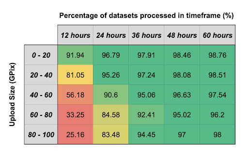
The above chart is based on data from surveys uploaded
between August 11, 2024 to January 31, 2025.
Calculating the Number of Gigapixels In Your Survey:
A gigapixel (GP) is a unit of measure that is used to calculate how large a survey dataset upload is. It is defined as one billion (109) pixels. To calculate how many gigapixels are in your survey, you can use the following formula:
Survey size = resolution of camera x number of images
For example:
- If you surveyed an area using a Phantom 4 RTK (20MP sensor) and captured 1000 images, your total survey size would be 20 GP.
- If you surveyed an area using a Matrice 300 with a P1 camera (45MP sensor) and captured 1000 images, your total survey size would be 45 GP.
Factors that Lead to Processing Rejection
Sometimes datasets uploaded into Propeller will be deemed “unusable” after our Data Success team has completed a thorough investigation. In these scenarios, if we are unable to create a model from the data, we reserve the right to reject the uploaded survey after communicating with the customer.
Some examples of when we will need to reject a dataset include, but are not limited to:
- PPK surveys with majority low-fix geotags or low quality AeroPoints due to AeroPoint placement and/or short flights.
- For a PPK survey using an AeroPoint 1, short flights are less than 10 minutes.
- For a PPK survey using an AeroPoint 2, short flights are less than 2 minutes.
- If using the Known Point Method for AeroPoint corrections, short flights are less than 10 minutes if using any other method for AeroPoint corrections.
- Severe motion blur.
- Extremely under / overexposed images.
- Images are all water or tall trees/dense vegetation.
- Insufficient photo overlap. We recommend a minimum of 70% at a standard flight height of 80-120 meters AGL but 75%-80% is optimal where there is a lot of change in topography.
Customers will be notified when their dataset has finished processing and is ready to view in the platform.
We will also contact you if:
- We have questions about the data that must be answered before processing can continue.
- There are any processing delays.
- Changes were made to any of the options selected during upload (ex. Excluding GCPs that were not captured in any of the photos).
- We find any issues during our Quality Assurance and Control Process that prevents us from releasing the survey.
If we do not receive a response from the customer in a reasonable timeframe (typically 2 weeks from when the dataset was uploaded), and after we have made multiple attempts to contact the customer, we may reject the survey and send a notification email as mentioned above.
Reprocessing or Refiltering Requests
Propeller is able to reprocess or refilter datasets on request. This may incur additional credit usage on credit-based packs.
Quality Assurance and Control
Quality and Control Improvement
Each ground-controlled dataset uploaded to Propeller is expertly transformed into a 3D site model by our processing engine, using our proprietary algorithms and photogrammetric tools.
Each survey is also reviewed by our highly experienced Geospatial Specialists to ensure the highest quality outcome. Some of our most common quality-improvement tasks include, but are not limited to:
- Offsetting moderately incorrect geotags from multiple flights for standard accuracy surveys.
- Assessing and selectively removing low-quality images that may degrade the site model.
- Validating the accuracy of geotags.
- Omitting GCPs that degrade the site model.
- Validating and adjusting image alignment in the site model.
- Attempting imagery alignment with adjusted camera calibration.
The level of troubleshooting will depend on the selected Quality Assurance setting at the time of upload. Propeller offers Strict, Moderate, and Lenient Quality Assurance settings where customers can select the option appropriate for the accuracy required of the dataset, as well as the option to ”Skip all QA” for the fastest turnaround time possible:
- Strict ensures that datasets will be checked using the highest standards and tightest thresholds.
- Lenient uses looser thresholds which generally leads to faster processing times.
- Skip all QA has no troubleshooting hold ups which leads to fastest turnaround time because the entire processing is done automatically and it opts out of quality assurance entirely. The same level of accuracy can still be achieved provided that data capture is good.
| Quality Assurance Setting | Internal Accuracy Threshold (GCP error) | Consistency Threshold (Comparison with previous survey) |
| Strict | 0.05 m | 0.16 ft/USft | 0.1 m | 0.33 ft/USft |
| Moderate | 0.1 m | 0.33 ft/USft | 0.2 m | 0.66 ft/USft |
| Lenient | 0.2 m | 0.66 ft/USft | 0.4 m | 1.31 ft/USft |
Processing Report
For every survey dataset we process, a Processing Report is generated that shows how well your provided data matches the surface we created. It includes:
- Ground control summary
- Ground control RMS errors
- Camera locations
- DEM surface checkpoints
- Filter analysis
- Camera quality analysis
This report can be viewed, shared, and printed from the platform.
Ensuring Consistency
When a site has been surveyed more than once, we compare overlapping survey results to ensure consistency between survey products. If both surveys have ground control, we evaluate whether they line up horizontally and vertically within standard error tolerances.
We also check for any shifts or misalignment between images and for unexpected surface differences (not caused by vegetation or earthworks).
Deliverables
Standard Data Outputs Generated by Propeller
Propeller’s photogrammetry processing services turn your drone images into actionable 3D data, delivered directly to your portal in the Propeller Platform. There, you can visualize and interact with your 3D surveys to measure and manage your worksites with our specialized tools.
We generate industry-standard spatial data products that will seamlessly integrate with your other systems, including but not limited to Trimble Business Center, Civil 3D, and Autodesk.
From the platform, the following standard output deliverables are available for download in the site’s coordinate system, unless stated otherwise. Source imagery can also be made available for download upon request.
Site Model:
- DXF in 3 resolutions (100k, 250k and maximum achievable faces)*
- TTM (Trimble Stratus only)*
- 2.5D textured model (OBJ format)*
Terrain:
- DSM GeoTiff
- DTM GeoTiff (for datasets that were processed using any of our filter options)
- Contours
- DXF (non georeferenced*)
- 1 m intervals for sites set up with meters
- 1 ft/USft and 2 ft/USft for sites set up with feet or US feet
Orthophoto:
- GeoTIFF in WGS 84
- GeoTIFF
- JFIF/JPEG full resolution (zipped with world files)
- JFIF/JPEG lower resolution (zipped with world files)
Point Cloud:
- LAZ in WGS 84
- LAZ
- LAZ (Reduced point count)
Propeller exports AeroPoint survey data in the following formats:
- CSV
- KML
Propeller exports PPK image tags in the following format:
- CSV
*While the data is in the appropriate CRS, metadata is not supported by these file types. The corresponding coordinate reference system will need to be set when loading into a 3rd party software.
Custom Data Outputs Created by Customers in the Propeller Platform
From the Propeller Platform, customers can also create and export some custom data products by creating a measurement polygon. These include:
- DXF Outline
- KML
- DXF Surface (triangles)
- DXF Contours (1 unit interval)
- Point Cloud (customizable point count in LAS, LAZ or CSV format)
- Orthophoto (customizable orthophoto in GeoTIFF or JPEG format)
- TTM Surface (Trimble Stratus)
We test each file format to ensure they are compatible and performing as they would in your portal. You can read more about the third-party software that supports our exports here.
Composite Datasets Created by Customers in the Propeller Platform
In the platform, you can create composites of up to 25 partial surveys or pre-processed datasets once they have completed processing.
The composite will become available as a new dataset, for which all measurement and analysis tools will be available, with the exclusion of terrain cleanups. However, terrain cleanups from its partial are carried over to the composite.
Whole-site deliverables in the FILES modal are not available for composite surveys, but surfaces and orthophotos can be exported through the Custom Data Outputs Created by User in the platform. Custom point cloud export is not yet supported for composites.
Crew
Crew provides an easy way to share interactive maps with design, earthworks quantities, and location information between the office and the field. Crew includes:
- 2D site overview
- Map details
- Design file overlays
- Real-time GPS location
Customer Support
Customer Support Channels
Propeller offers multiple avenues for customer support:
-
-
- In-Platform Support
- 24/7 Live Chat Support
- Knowledge Base
- PropellerU video training library
- In-Platform Support
- Customer Success Support
- Software license customers have access to a Customer Success Engineer during local business hours.
- Hardware Support
- Software license customers have access to Hardware Support for assistance with hardware needs via phone, email and chat during local business hours. This includes:
- Airspace Unlocks
- Hardware troubleshooting for supported drones
- AeroPoints assistance
- Hardware-only customers have access to Hardware Support via email or chat for assistance with hardware needs. This includes:
- AeroPoints assistance
- PPK upgrade assistance
- For some drones, Propeller is only able to provide limited hardware support, and customers may need to seek assistance from the manufacturer depending on the issue. You can find the support we offer by visiting our Support Resources.
- Software license customers have access to Hardware Support for assistance with hardware needs via phone, email and chat during local business hours. This includes:
- Technical Support
- Software customers receive support for assistance with technical inquiries about the platform or processed data via phone, email and chat during local business hours. This includes:
- Photogrammetry issues and best practices
- File imports and exports
- Coordinate systems
- Propeller Platform functionality and tools
- US customers have access to a dedicated Technical Support Team during MST business hours. For all other regions, please contact your Customer Success representative or use our 24/7 chat support.
- Software customers receive support for assistance with technical inquiries about the platform or processed data via phone, email and chat during local business hours. This includes:
- Non-English support limitations
- The Propeller Platform is available in French, German, Japanese, Spanish, Italian, and Czech.
- Propeller is only able to provide chat, email or phone support in English. Local dealers may be able to provide support in local languages. Contact your dealer for more information.
-
Data We Do Not Accept
Propeller does not currently accept or provide support for:
-
-
- Thermal and Multispectral Imagery
- Pre-processed Tiled 3D Models
- Unreferenced image files for spatial overlay
- Unprocessed LiDAR point clouds
- Shapefiles or geodatabase files
-
Data Services We Do Not Provide
To ensure that we can maintain quick high-quality service to all of our customers, Propeller does not engage in extensive manual data preparation, such as:
-
-
- Processing datasets requiring excessive manual tie points or where 50% of photos cannot be aligned. Examples include, but are not limited to, sites covered extensively by: water, tree canopies or thick vegetation, corrugated roofs, reflective or highly uniform surfaces, close-up inspection of repetitive surfaces and trusses.
- Creating geotags for images without human-readable log files.
- Manually adjusting brightness and exposure of images.
- Manually aligning imagery with unacceptably poor overlap (less than 60%).
- Manual acquisition or manipulation of CORS correction data for surveys older than one month.
- Removing sky from source imagery.
-
LiDAR Services Description
This service includes Propeller georeferencing and processing of user-provided LiDAR data into ground/non-ground classification that can be viewed and measured as a bare earth model in the Propeller Platform, along with the other data in a customer’s site. For further information, refer to Photogrammetry Data Services Description – Current Pricing.
Product Specifications
| Description | Terms |
| Credits | Depends on purchase |
| Drones | Unlimited but restricted to DJI Zenmuse L1/L2/L3 sensor |
| GigaPixels per credit | 20 |
| Max GigaPixels per upload | 155 |
Pack Details
-
-
- Each image:
- Must be at least 7 megapixels.
- Must be geotagged.
- Must have a file name with fewer than 255 characters.
- Each upload:
- Must be one contiguous area.
- Must use the DJI RTK or Propeller PPK workflow.
- Must use a minimum of 2 GCPs for sites with local CRS.
- Must use DJI M300/350/400 with DJI Zenmuse L1/L2/L3 and follow the recommended mission planning.
- Must use the following files: CLC, .CLI, .IMU, .LDR, .LDR~1 (if available), .RTB (for RTK), .RTK, .RTL, .RTS.
- Images must fully cover the area of the survey.
- Each image:
-
Supported UAS and Coordinate Systems
Drones and Camera Systems
Supported Drones:
-
-
- The supported drone has been specifically selected for compatibility with Propeller and will provide the best user experience.
- DJI M300 with Zenmuse L1/L2.
- DJI M350 with Zenmuse L1/L2.
- DJI M400 with Zenmuse L2/L3
-
Drone Support:
-
-
- We offer technical hardware support and training on data capture and upload for the DJI M300, DJI M350 with Zenmuse P1 and L1/L2 and DJI M400 with Zenmuse P1, L2 and L3.
-
User Supplied RINEX Data
RINEX data can be self supplied for processing. This is the list of all compatible antenna types.
AeroPoint Surveys:
-
-
- AeroPoint surveys can be processed using the RINEX Upload Method, which uses the user supplied data to process AeroPoint coordinates.
-
The accuracy of the final model will depend on the accuracy of the supplied RINEX file.
Coordinate Reference Systems (CRS)
Typically Continuously Operating Reference Stations (CORS) publish the data in 24 hours and store it for a certain period – generally 30 days or less for the majority of networks. Some store for a longer term, but they reduce the quality after 30 days.
If a base station has no available data for 12 hours, we will manually check and fetch data from other nearby stations if they exist, which may delay the process. After the 12-hour mark, we will use any in-range base station data, rather than wait for the closest.
Supported CRS:
-
-
- Many ellipsoid and geoid datums, and many published projected systems.
- Most JXL and GC3 local calibrations.
-
Propeller Corrections Network (PCN) allows users to have their AeroPoints processed and corrected without the need for local ground control markings to be made.
To use PCN on your site:
-
-
- The site needs to be within range of a PCN base station (check this map).
- The station needs to provide data in a compatible CRS.
-
To definitively find out whether your desired setup is supported, please contact us.
Data Processing
Propeller Processing Methods
Each LiDAR dataset uploaded to Propeller is transformed into a classified 3D site model by our processing engine, using our proprietary algorithms and LiDAR data processing tools.
We support the processing of survey datasets:
-
-
- Submitted with DJI RTK collector base station data (.RTB file).
- Submitted without .RTB but with GCPs (AeroPoints and custom GCPs).
- Submitted with high accuracy (PPK or RTK) geotags.
- Using the Propeller LiDAR solution.
-
Propeller Corrections:
Data can be processed using AeroPoints and custom GCPs.
-
-
- AeroPoint surveys can be processed using the following methods:
- Propeller Correction Network (PCN)
- Known Point (Global Site Survey Benchmark)
- Known Point (Local Site Survey Benchmark)
- User supplied RINEX
- For the Known Point methods, if the PCN is available, it may be automatically used to help increase the quality of the AeroPoint captures.
- AeroPoint surveys can be processed using the following methods:
-
Non-Propeller Corrections:
Data should include DJI RTK collector data (.RTB) and photos that have high accuracy (PPK or RTK) geotags. The data can be processed with customer GCPs and AeroPoints.
-
-
- Customer GCPs are recommended to be checkerboard types in order to ensure visibility when processing.
-
Standard Processing & Delivery Timeframe
Expected Processing Times:
LiDAR surveys captured using the Propeller LiDAR and AeroPoints workflow and utilizing our best practices can expect faster processing times.
Factors that Extend Processing Time or Delay Delivery:
-
-
- If your dataset is larger than the standard size of 300M points.
- Uploaded data requires manual corrections due to non-ideal or inefficient collection methods.
- Conflicting CRS.
- User input errors at upload (incorrect information, incomplete files, incorrect file naming, etc).
- Ground control point (GCP) identification errors or missing GCPs.
- Corrupt or incomplete data.
- Lengthy delays responding to processing questions or clarifications requested by Propeller staff.
-
Processing Time Commitment:
The following are the processing and delivery timeframes we uphold when processing your survey data. Our commitment is to meet these timeframes for at least 90% of all uploads. For your dataset to be eligible for these timeframes, it must:
-
-
- Be captured using a supported drone.
- Have GNSS corrections data available within 12 hours of submission (if using the Propeller Corrections Network).
- Have high-accuracy geotags on images (PPK or RTK) and/or visible and accurately marked ground control points.
- Not include any factors that extend processing times (as described above).
-
The processing and delivery timeframe is defined as the time taken for the dataset to be first available for the customer to review following a successful upload.
| Upload Size | less than 20 GigaPixels | 20 – 40 GigaPixels | 40 – 60 GigaPixels | more than 60 GigaPixels |
| Processing & Delivery Timeframe | 24 hours | 48 hours | 72 hours | custom / 96 hours |
Factors that Lead to Processing Rejection
Sometimes datasets uploaded into Propeller will be deemed “unusable” after our Data Success team has completed a thorough investigation. In these scenarios, if we are unable to create a model from the data, we reserve the right to reject the uploaded survey after communicating with the customer.
Some examples of when we will need to reject a dataset include, but are not limited to:
-
-
- For Propeller LiDAR solutions, datasets with AeroPoint surveys that have no good quality AeroPoints due to AeroPoint placement and less than recommended capture times:
- For an AeroPoint survey using an AeroPoint 1, capture times less than 45 minutes.
- For an AeroPoint survey using an AeroPoint 2, capture times less than 10 minutes.
- Insufficient photo overlap. We recommend a minimum of 50% at a standard flight height of 200 feet.
- Insufficient LiDAR data, where the LiDAR data does not fully cover the survey area.
- For Propeller LiDAR solutions, datasets with AeroPoint surveys that have no good quality AeroPoints due to AeroPoint placement and less than recommended capture times:
-
Customers will be notified when their dataset has finished processing and is ready to view in the platform.
We will also contact you if:
-
-
- We have questions about the data that must be answered before processing can continue.
- There are any processing delays.
- Changes were made to any of the options selected during upload (ex. Excluding ground control markers that are not viewable in the point cloud).
- We find any issues during our Quality Assurance and Control Process that prevent us from releasing the survey.
-
If we do not receive a response from the customer in a reasonable timeframe (typically 2 weeks from when the dataset was uploaded), and after we have made multiple attempts to contact the customer, we may reject the survey and send a notification email as mentioned above.
Reprocessing Requests
Propeller is able to reprocess datasets on request. This may incur additional credit usage.
Quality Assurance and Control
Quality and Control Improvement
Each LiDAR dataset uploaded to Propeller is transformed into a 3D site model by our processing engine, using our proprietary algorithms.
Each survey is also reviewed by our Geospatial Specialists to ensure the highest quality outcome. Some of our most common quality-improvement tasks include, but are not limited to:
-
-
- Omitting ground control points that degrade the site model.
- Omitting obvious high and low noise points which can degrade the production of a logical elevation model.
- Checking the elevation values of the points in a flight line that differs significantly with the overlapping points on a contiguous flight line.
-
Processing Report
For every survey dataset we process, a Processing Report is generated that shows how well your provided data matches the surface we created. It includes:
-
-
- Ground control accuracy
- Checkpoint accuracy (if applicable)
- LiDAR elevation
- LiDAR density
-
This report can be viewed, shared, and printed from the platform.
Deliverables
Standard Data Outputs Generated by Propeller
Propeller’s LiDAR processing services turn your drone images into actionable 3D data, delivered directly to your portal in the Propeller Platform. There, you can visualize and interact with your 3D surveys to measure and manage your worksites with our specialized tools.
We generate industry-standard spatial data products that will seamlessly integrate with your other systems, including but not limited to Trimble Business Center, Civil 3D, and Autodesk.
From the platform, the following standard output deliverables are available for download in the site’s coordinate system, unless stated otherwise.
-
-
- Platform visualization:
- Basic orthophoto
- Terrain
- Point cloud with classification
- Static Download:
- Basic orthophoto in the site CRS (GeoTIFF)
- Point cloud in the site CRS (LAS)
- Processing report (PDF)
- Terrain in site CRS (GeoTIFF)
- Contours (DXF)
- Dynamic Download:
- Basic orthophoto (GeoTIFF or JPEG)
- Outline (DXF or KML)
- Surface (DXF or TTM (usually for Stratus only))
- Contours (DXF)
- Point cloud (LAS, LAZ or CSV)
- Reports (Miscellaneous):
- Stockpile Inventory Report
- Measurement report
- Takeoff Map
- PDF Map
- Platform visualization:
-
We test each file format to ensure they are compatible and performing as they would in your portal. You can read more about the third-party software that supports our exports here.
Composite Datasets Created by Customers in the Propeller Platform
In the platform, customers can create composites of up to 25 partial surveys or pre-processed datasets once processing is complete.
The composite will become available as a new dataset, for which all measurement and analysis tools will be available, with the exclusion of terrain cleanups. However, terrain cleanups from its partial are carried over to the composite.
Whole-site deliverables in the FILES modal are not available for composite surveys, but surfaces and orthophotos can be exported through the Custom Data Outputs Created by User in the platform. Custom point cloud export is not yet supported for composites.
DirtMate Data Services Description
DirtMate 3D Surface Generation
This service includes the generation of 3D surfaces within the Propeller Platform. Provided that the system is set up and connected, the DirtMate system will automatically generate the following data at the specified time intervals. Please note these are subject to change due to performance optimization and other reasons.
| Description | Frequency of Generation |
| Data capture frequency for position and utilization data | Every 1 second |
| 3D surface generation | Every 30 minutes |
Within the Propeller application itself, you can interact with the surface data in the following ways:
-
-
- The visualization of surface data generated by DirtMate equipped equipment.
- Creating volumetric or other measurements utilizing the generated surface.
-
The surface data is generated using post processed kinematic (PPK) corrected GNSS samples collected from the DirtMate receivers. 3D surfaces are generated from all active DirtMate receivers. Specific receivers can be disabled from contributing to surface generation, however you cannot generate a surface from a specific receiver.
Mobile Plant Utilization and Location Tracking
This service includes the generation of equipment utilization data and position data using the data obtained from DirtMate units mounted to moving heavy machinery. The equipment (machine) utilization data includes both the position and operational status such as idling and operational. Provided that the system is connected, the DirtMate system will automatically generate the following data at the specified time intervals. Please note these are subject to change due to performance optimization and other reasons.
| Description | Frequency of Generation |
| Data capture frequency for position and utilization data | Every 1 second |
| Machine utilization | Every 30 seconds |
| Machine position (trails) generation | Every 1 second |
Within the Propeller application itself, you can interact with this machine utilization and location data in the following ways:
-
-
- Tabulation of data showing how long each DirtMate equipped equipment was in each operational status for a given timeframe.
- Visualization of machine position as a visual trail for a given time period.
- How many vehicle “dump” and “load” events were made given chosen parameters.
-
These utilization values are calculated using a combination of vibration data collected using an onboard accelerometer, as well as GNSS position data. Utilizations thresholds and may be calibrated to increase accuracy. The location data uses GNSS data that has not been corrected through high accuracy means, such as PPK.
DirtMate Position Monitoring
DirtMates may be configured to be used in a position monitoring mode. In this mode, the DirtMate unit is used to generate a PPK corrected GNSS position. This position data is available on the Propeller Platform or can be accessed through the use of an externally addressable API. This data is generated at the intervals specified below:
Generation of Data (Position Monitor)
| Description | Frequency of Generation |
| Position data | Up to every 1 second with configurable sleep and wake times |
Data Generation & Availability
Data collected from DirtMate devices is transported to the Propeller cloud via an internet connection. Propeller does not guarantee the uptime and availability of this internet connection as it is impacted by factors beyond our control and is dependent on the internet service used (such as the loss of cellular signal due to network outages). Additionally as DirtMates are battery powered devices there may be a loss of power of the device due to insufficient charge if a charging source is not maintained. As such the DirtMate system cannot be relied upon as a real-time device.
If a DirtMate loses connection to the server it will continue to store data locally on the internal memory of the device. Once the data storage capacity is reached, the earliest data will be overwritten with new data. This data would then not be recoverable.
DirtMate is not a real-time system and it cannot be guaranteed to operate in that manner.
Data Storage
DirtMate data is included in the subscription price and does not contribute to the storage totals and fees associated to a Propeller Platform license. This is subject to change.
Photogrammetry Data Services Description – Legacy Pricing
Product Specifications
Pack Comparison
| Credit Pack | Unlimited Pack – 2,000 photo limit | Unlimited Pack – 4,000 photo limit | Unlimited Pack – 5,000 photo limit | “Bring Your Own Data” (BYOD) Pack | |
| Credits | Usually 15, 30, 55, or 110 | Unlimited | Unlimited | Unlimited | Usually 15, 30, 55, or 110 |
| Drones | Unlimited | 1 (more can be purchased) | 1 (more can be purchased) | 1 (more can be purchased) | – |
| Photos per Credit | 1,000 photos regardless of camera resolution | – | – | – | – |
| Max Photos per Upload | 10,000 photos up to 210 GP | 2,000 photos up to 210 GP | 4,000 photos up to 210 GP | 5,000 photos up to 210 GP | – |
| Ground Control Points (GCP) per Credit | 40 GCP | – | – | – | |
| Max GCPs per Upload | 400 GCP | 80 GCP | 80 GCP | 80 GCP | – |
| Check-points | Unlimited (fair usage up to 2,400 applies) | Unlimited (fair usage up to 2,400 applies) | Unlimited (fair usage up to 2,400 applies) | Unlimited (fair usage up to 2,400 applies) | – |
| Pre-processed Data per Credit | 4 GP | – | – | – | 4 GP |
| Max Pre-processed Data per Upload | 40 GP | – | – | – | 40 GP |
| Point Cloud per Credit | 100M points | – | – | – | 100M points |
| Max Point Cloud per Upload | 1B points | 300M points | 300M points | 300M points | 1B points |
| Number of Sites | Unlimited | Unlimited | Unlimited | Unlimited | Unlimited |
| Number of standard users | Unlimited | Unlimited | Unlimited | Unlimited | Unlimited |
| Number of view-only users | Unlimited | Unlimited | Unlimited | Unlimited | Unlimited |
All Pack Type Details
-
-
- Each image:
- Must be at least 8 megapixels.
- Must be geotagged.
- Must have a file name with fewer than 255 characters.
- Should have less than 30mm of motion blur, otherwise, the effectiveness of stitching images is reduced leading to low accuracy in the final model.
- Must have an acceptable aspect ratio and ISO for your camera’s specifications.
- Each upload:
- Must be one contiguous area. This is to avoid excessively long processing times and ensure accuracy in the resulting 3D model.
- Must have at least 10 images with the same aspect ratio.
- Each image:
-
Credit Pack Details
-
-
- Additional Credits will be charged for:
- Each additional 1,000 images over the stated limit OR
- Each additional 40 GCP over the stated limit.
- Additional Credits will be charged for:
-
Unlimited Pack Details
-
-
- If you attempt to upload a dataset that is more than 2,000 images but your limit is set to 2,000 images, you can:
- Use composite surveys.
- Purchase a credit pack
- Upgrade to a higher image limit pack.
- Propeller’s systems automatically restrict your uploads to the single drone device you have registered to the license. Certain packs restrict usage to recommended drones and supported drones only. If you’re unsure of your purchase, contact your Account Manager.
- Replacing your drone:
- Propeller will provide a method for limited self-service temporary drone replacements.
- If you replace your drone or drone’s camera device, you will need to contact Propeller support to update your license.
- When you add new drones, contact your Account Manager to discuss additional licenses.
- If you attempt to upload a dataset that is more than 2,000 images but your limit is set to 2,000 images, you can:
-
“Bring Your Own Data” Pack Details
-
-
- A pre-processed credit is defined as an output from your photogrammetry processing solution or other survey data sources in GeoTIFF format.
- The site must be in a projected system and the upload must match the site CRS. Pre-processed data in WGS84 GeoTIFF cannot be updated into published or local sites. However, if you have existing WGS84 GeoTIFF assets and need to import this historical data into the platform, please reach out to our Sales Engineers so that we can assist you with the transition process.
-
Requirements:
-
-
- One digital elevation model (DEM) and/or one orthophoto GeoTIFF file.
- GeoTIFF files should have unique names if you upload more than one to the platform.
- Your orthomosaic should be 4 bands RGB+Alpha (instead of 5 bands).
- DEM should have a 32-bit floating-point sampling. An integer sampling creates a stepped elevation phenomenon across the model, making it unreliable.
- 8 bit color channels
- One digital elevation model (DEM) and/or one orthophoto GeoTIFF file.
-
Pre-Processed Credit Sizes:
-
-
- Standard pre-processed Credit size: 4,000 megapixels, referring to the resolution of the GeoTIFF files uploaded
- For clarity, this includes GeoTIFFs with dimensions of just over 63,000 x 63,000 pixels height and width; or 40,000 x 100,000, or 10,000 x 400,000.
- You can upload a matching orthophoto (colored RGBA) image and a DEM (greyscale) image together. The limit applies to the larger file of the pair.
- Pixels are counted regardless of their transparency.
- Standard pre-processed Credit size: 4,000 megapixels, referring to the resolution of the GeoTIFF files uploaded
-
What Other Pre-Processed Data Can Be Uploaded?
Preprocessed Point Clouds:
-
-
- LAS or LAZ (zipped LAS) format in the site coordinate system.
-
Design Surfaces and Spatial Overlays:
-
-
- Design surfaces (georeferenced PDF, DXF, TTM, IFC, KML, KMZ or LandXML (CgPoints and Surfaces only))
- Maximum file size is 500MB and 300 MB for IFC files.
- 3DFACE or MESH surface layers containing more than 1,000,000 faces will not be displayed and cannot be used for measurement purposes.
- Linework (KML, KMZ, DXF)
- For linework, files less than 2MB display better in the platform.
- Keep individual file sizes below 20MB.
- Georeferenced elevation models (DEM GeoTIFF).
- Design surfaces (georeferenced PDF, DXF, TTM, IFC, KML, KMZ or LandXML (CgPoints and Surfaces only))
-
File Storage:
-
-
- Unreferenced image files (such as PNG or PDF)
- Unlimited total storage available per portal
-
Expiration and Data Retention
Dataset Credit Expiration:
-
-
- At the end of the term determined in their contract, customers will lose access to the platform unless they have renewed their subscription.
- Unused dataset credits, including oversized surveys purchased within the platform, will expire and no longer be usable at the end of the term.
- Dataset credits do not roll over into the next term.
- Dataset credits cannot be exchanged for refund or discount.
-
Platform Data Retention:
-
-
- As a platform user, you can delete data that you no longer need or is no longer relevant to your project. Once deleted, the data is irrecoverable.
- If you let your platform license expire, your data will be deleted permanently after 14 days, unless you renew your license before then or purchase paid hosting. After 14 days, your data is irrecoverable, even if you do eventually renew.
- Click to read more about our Data Retention Policy.
-
AeroPoint Survey Data Retention:
-
-
- If you let your AeroPoint subscription expire, you will still be able to access and download all AeroPoint surveys that were processed before the subscription expired.
- AeroPoint surveys that are uploaded while the AeroPoint subscription is expired will be blocked from processing or downloading until the subscription is resumed.
-
Hardware-only Customer License Types
Annual AeroPoint Processing Subscription
-
-
- To process the data from AeroPoints, hardware-only customers must maintain the annual AeroPoint subscription, which is included with the purchase of new AeroPoints for the first 12 months.
- Subscription covers:
- AeroPoints simple user workflow, including hotspot uploading.
- The AeroPoints Dashboard provides multiple outputs, including processing reports and battery health.
- The ability to process coordinate data in multiple methods: Propeller Correction Network, user supplied known point method, and user supplied RINEX file.
- Simple processing in public grids.
- The hosting, permission-based sharing and organization of data over time.
- Any active software license or Annual Propeller PPK subscription includes the AeroPoints subscription.
- More information about this subscription can be found here.
-
Annual Propeller PPK subscription
-
-
- To process the PPK-geotagged images, hardware-only customers must maintain the annual Propeller PPK subscription.
- Photos are processed with high accuracy geotags, and the data can only be processed with AeroPoints and supported by Propeller PPK solution drones.
- This subscription covers:
- The Propeller PPK algorithm and AeroPoints simple user workflow, including hotspot uploading.
- The web-based software service that enables PPK tagging of images.
- The AeroPoints Dashboard, which provides multiple outputs, including processing reports and battery health.
- The ability to process coordinate data in multiple methods: Propeller Correction Network, user supplied known point method, and user supplied RINEX file.
- Simple processing in public or local grids (with Trimble and Topcon local site calibration workflows).
- The hosting, permission-based sharing, and organization of data over time.
- Any software license includes PPK and AeroPoints processing.
- More information about this subscription can be found here.
-
Limitations
Certain limitations apply to hardware-only customers, including but not limited to:
-
-
- AeroPoint groups can only contain a maximum of 20 AeroPoints.
- Customer support via phone is not available.
- Customer support may take up to one business day to respond.
- AeroPoint corrections data may take up to 24 hours to retrieve.
-
Supported UAS and Coordinate Systems
Drones and Camera Systems
PPK-enabled Drones:
PPK-enabled drones have been specifically selected for optimization with Propeller PPK and will provide the best user experience.
-
-
- DJI Matrice 4 Enterprise
- DJI Mavic 3 Enterprise
- DJI Phantom 4 RTK
- WingtraOne Gen I / Gen II with Map61, RGB61, Sony a6100, Sony RX1R II
- WingtraRAY with Map61 and Survey61
- DJI M300/M350 with Zenmuse P1/L1/L2
- DJI M400 with Zenmuse P1/L2
- Quantum Trinity F90+
- Anzu Raptor
- Autel Evo II Pro RTK V1/V2
- Autel Evo II Pro RTK V3
- Skydio X10
-
Freefly Astro
-
Platform Compatible Drones:
Below drones are compatible with the Propeller Platform, but may have limited functionality and will not support the complete PPK solution.
-
-
- DJI Phantom 4 Pro
- DJI Phantom 4 Pro V2
- DJI Zenmuse X7 – Matrice 210 RTK V2
- SenseFly S.O.D.A – Ebee
- SenseFly Aeria X – Ebee
-
See all supported drones here.
Drone Support:
-
-
- Full support and training on data capture and upload (DJI P4RTK, DJI M300/M350 with Zenmuse P1/L1/L2, DJI M400 with Zenmuse P1/L2 DJI M4E, DJI M3E, DJI P4P).
- Support for data upload only (Wingtra, Quantum, Anzu Raptor, Autel, Skydio).
-
Propeller PPK
-
-
- For hardware-only customers, Propeller PPK requires a subscription to annual corrections.
- When uploading imagery captured with drones that are compatible for use with Propeller PPK, each upload must include the following file types:
- DJI: BIN/RTK and MRK.
- Wingtra: SBF and JSON. Include only the original FlightName WingtraOne.SBF and FlightName.JSON files. Geotagging within WingtraHub will result in additional SBF and JSON files, do not upload these to the platform.
- Quantum: UBX and PROP.
- Each drone flight must be captured completely within the duration of the corresponding AeroPoint survey.
-
User Supplied RINEX Data
RINEX data can be self supplied for processing. This is the list of all compatible antenna types.
AeroPoint Surveys:
-
-
- AeroPoint surveys can be processed using the RINEX Upload Method, which uses the user supplied data to process AeroPoint coordinates.
-
PPK Surveys:
-
-
- While the Propeller Corrections Network is the simplest way to process a PPK survey, you can process PPK data with RINEX data.
-
In both of these cases, the accuracy of the final model will depend on the accuracy of the supplied RINEX file.
Coordinate Reference Systems (CRS)
Typically Continuously Operating Reference Stations (CORS) publish the data in 24 hours and store them for a certain period – generally 30 days or less for the majority of networks. Some store longer term, but they reduce the quality after 30 days.
If a base station has no available data for 12 hours, we will manually check and fetch data from other nearby stations if they exist, which may delay the process. After the 12-hour mark, we will use any in-range base station data, rather than wait for the closest.
Supported CRS:
-
-
- Many ellipsoid and geoid datums, and many published projected systems.
- Most JXL and GC3 local calibrations.
-
Propeller Corrections Network (PCN) allows users to have their AeroPoints processed and corrected without the need for local ground control markings to be made.
To use PCN on your site:
-
-
- The site needs to be within range of a PCN base station (check this map).
- The station needs to provide data in a compatible CRS.
-
To definitively find out whether your desired setup is supported, please contact us.
Data Processing
Propeller Processing Methods
Each survey dataset uploaded to Propeller is transformed into a 3D site model by our processing engine, using our proprietary algorithms and photogrammetric tools.
We support the processing of survey datasets:
-
-
- With or without GCPs (AeroPoints and/or custom GCPs).
- Submitted with standard accuracy or high accuracy (PPK or RTK) geotags.
- Using the Propeller PPK solution.
-
Propeller PPK:
Photos are processed with high accuracy geotags, and the data can be processed with / without customer GCPs and AeroPoints.
-
-
- PPK geotags can be processed using the following methods:
- Propeller Correction Network (PCN)
- Known Point (Global Site Survey Benchmark)
- Known Point (Local Site Survey Benchmark)
- User supplied RINEX
- For the Known Point methods, if the PCN is available, it may be used automatically to help increase the quality of the geotags.
- For more details on Propeller PPK, please visit our Knowledge Base.
- PPK geotags can be processed using the following methods:
-
Non-Propeller PPK:
Photos can be standard accuracy or other high accuracy (PPK or RTK) geotags. The data can be processed with or without customer GCPs and/or AeroPoints.
-
-
- AeroPoints can be processed using the following methods:
- Propeller Correction Network (PCN)
- Known Point (Global Site Survey Benchmark)
- Known Point (Local Site Survey Benchmark)
- User supplied RINEX
- Unreferenced (Unreferenced uses coarse GNSS locations and only provides relative accuracy)
- Customer GCPs
- Without GCPs
- AeroPoints can be processed using the following methods:
-
Downsampling
We typically downsample dense cloud data by 1:4 during processing. Our testing has shown that this reliably provides accurate results when best data capture practices are followed.
For example, if the captured GSD was 2 cm/pixel, the downsampled dense cloud will be 8 cm/pixel. This allows us to reduce processing time for large datasets, and we perform further downsampling for very large datasets. Here are our thresholds for downsampling when building the dense cloud:
-
-
- They are based on the total number of pixels in the source photos, measured in gigapixels (GP).
- They have been designed to rarely be used. Between January 1, 2021 and May 17, 2021, less than 2% of surveys exceed any of these thresholds.
-
| Thresholds for each pack type | Results | ||||
| Downsampling when an upload exceeds the relevant threshold | Credit packs | Unlimited – up to 5,000 images | DEM GSD compared to what was captured | Point cloud density compared to what’s possible to reconstruct | |
| 1:8 | 60 GP | 90 GP | 8 x | 1/64 x | |
| 1:16 | 120 GP | 180 GP | 16 x | 1/256 x | |
If you need to avoid heavy downsampling, you can survey the same area and stay underneath these thresholds by:
-
-
- Flying higher with less overlap.
- Subdividing the survey into smaller areas for processing and creating a composite afterwards.
-
Standard Processing & Delivery Timeframe
Expected Processing Times:
Photogrammetry surveys captured using the Propeller PPK with AeroPoints workflow, one of our ppk-enabled drones, and our best practices can expect faster processing times.
The following is a chart that shows the average photogrammetry survey processing times for our fastest top 10 and top 25 customers. The data is grouped by upload size to indicate how quickly surveys can be processed when using best practices.
The above chart averages processing data from surveys uploaded
between August 11, 2024 to January 31, 2025. Customers have uploaded
a minimum of 12 surveys per year to be included.
Factors that Extend Processing Time or Delay Delivery:
-
-
- If your dataset is larger than 40 GPix.
- Your data requires manual fixes due to non-ideal or unrecommended collection methods.
- If your AeroPoints corrections data is delayed. Processing can only begin once the corrections data is available. For urgent jobs, use the Known Point Method.
- User input errors at upload (incorrect information, incomplete files, etc.).
- Ground control point (GCP) identification errors or missing GCPs.
- Corrupt images or photo geotags.
- Lengthy delays responding to processing questions or clarifications requested by Propeller staff.
- Using non-standard outputs, such as tiled models (vertical face imagery).
-
Processing Time Commitment:
The following are the processing and delivery timeframes we uphold when processing your survey data. Our commitment is to meet these timeframes for at least 90% of all uploads. For your dataset to be eligible for these timeframes, it must:
-
-
- Be captured using a supported drone.
- Have GNSS corrections data available within 12 hours of submission (if using the Propeller Corrections Network).
- Have high-accuracy geotags on images (PPK or RTK) and/or visible and accurately marked ground control points.
- Not include any factors that extend processing times (as described above).
-
The processing and delivery timeframe is defined as the time taken for the dataset to be first available for the customer to review following a successful upload.
| Upload Size | Up to 20 gigapixels (GP) | 20 to 40 GP | 40 to 60 GP | 60 to 80 GP | 80 to 100 GP | >100 GP |
| Processing and Delivery Timeframe | 12 hours | 24 hours | 30 hours | 36 hours | 48 hours | Custom |
AeroPoint surveys that follow best practices generally come back within 24 hours.
Surveys up to 20 GP are often delivered in less than 12 hours. For datasets larger than 100 GP we are unable to guarantee a time frame due to the complexity of processing these large datasets.
To illustrate what typical processing times look like, the following chart shows the percentage of datasets grouped by upload size (GP) that achieve the listed timeframes:
The above chart is based on data from surveys uploaded
between August 11, 2024 to January 31, 2025.
Calculating the Number of Gigapixels In Your Survey:
A gigapixel (GP) is a unit of measure that is used to calculate how large a survey dataset upload is. It is defined as one billion (109) pixels. To calculate how many gigapixels are in your survey, you can use the following formula:
Survey size = resolution of camera x number of images
For example:
-
-
- If you surveyed an area using a Phantom 4 RTK (20MP sensor) and captured 1000 images, your total survey size would be 20 GP.
- If you surveyed an area using a Matrice 300 with a P1 camera (45MP sensor) and captured 1000 images, your total survey size would be 45 GP.
-
Factors that Lead to Processing Rejection
Sometimes datasets uploaded into Propeller will be deemed “unusable” after our Data Success team has completed a thorough investigation. In these scenarios, if we are unable to create a model from the data, we reserve the right to reject the uploaded survey after communicating with the customer.
Some examples of when we will need to reject a dataset include, but are not limited to:
-
-
- PPK surveys with majority low-fix geotags or low quality AeroPoints due to AeroPoint placement and/or short flights:
- For a PPK survey using an AeroPoint 1, short flights are less than 10 minutes.
- For a PPK survey using an AeroPoint 2, short flights are less than 2 minutes.
- If using the Known Point Method for AeroPoint corrections, short flights are less than 10 minutes if using any other method for AeroPoint corrections.
- Severe motion blur.
- Extremely under / overexposed images.
- Images are all water or tall trees/dense vegetation.
- Insufficient photo overlap. We recommend a minimum of 70% at a standard flight height of 80-120 meters AGL but 75%-80% is optimal where there is a lot of change in topography.
- PPK surveys with majority low-fix geotags or low quality AeroPoints due to AeroPoint placement and/or short flights:
-
Customers will be notified when their dataset has finished processing and is ready to view in the platform.
We will also contact you if:
-
-
- We have questions about the data that must be answered before processing can continue.
- There are any processing delays.
- Changes were made to any of the options selected during upload (ex. Excluding GCPs that were not captured in any of the photos).
- We find any issues during our Quality Assurance and Control Process that prevents us from releasing the survey.
-
If we do not receive a response from the customer in a reasonable timeframe (typically 2 weeks from when the dataset was uploaded), and after we have made multiple attempts to contact the customer, we may reject the survey and send a notification email as mentioned above.
Reprocessing or Refiltering Requests
Propeller is able to reprocess or refilter datasets on request. This may incur additional credit usage on credit-based packs.
Quality Assurance and Control
Quality and Control Improvement
Each ground-controlled dataset uploaded to Propeller is expertly transformed into a 3D site model by our processing engine, using our proprietary algorithms and photogrammetric tools.
Each survey is also reviewed by our Geospatial Specialists to ensure the highest quality outcome. Some of our most common quality-improvement tasks include, but are not limited to:
-
-
- Offsetting moderately incorrect geotags from multiple flights for standard accuracy surveys.
- Assessing and selectively removing low-quality images that may degrade the site model.
- Validating the accuracy of geotags.
- Omitting ground control points that degrade the site model.
- Validating and adjusting image alignment in the site model.
- Attempting imagery alignment with adjusted camera calibration.
-
The level of troubleshooting will depend on the selected Quality Assurance setting at the time of upload. Propeller offers Strict, Moderate, and Lenient Quality Assurance settings where customers can select the option appropriate for the accuracy required of the dataset, as well as the option to ”Skip all QA” for the fastest turnaround time possible:
-
-
- Strict ensures that datasets will be checked using the highest standards and tightest thresholds.
- Lenient uses looser thresholds which generally leads to faster processing times.
- Skip all QA has no troubleshooting hold ups which leads to fastest turnaround time because the entire processing is done automatically and it opts out of quality assurance entirely. The same level of accuracy can still be achieved provided that data capture is good.
-
| Quality Assurance Setting | Internal Accuracy Threshold (GCP error) | Consistency Threshold (Comparison with previous survey) |
| Strict | 0.05 m | 0.16 ft/US ft | 0.1 m | 0.33 ft/US ft |
| Moderate | 0.1 m | 0.33 ft/US ft | 0.2 m | 0.66 ft/US ft |
| Lenient | 0.2 m | 0.66 ft/US ft | 0.4 m | 1.31 ft/US ft |
Processing Report
For every survey dataset we process, a Processing Report is generated that shows how well your provided data matches the surface we created. It includes:
-
-
- Ground control summary
- Ground control RMS errors
- Camera locations
- DEM surface checkpoints
- Filter analysis
- Camera quality analysis
-
This report can be viewed, shared, and printed from the platform.
Ensuring Consistency
When a site has been surveyed more than once, we compare overlapping survey results to ensure consistency between survey products. If both surveys have ground control, we evaluate whether they line up horizontally and vertically within standard error tolerances.
We also check for any shifts or misalignment between images and for unexpected surface differences (not caused by vegetation or earthworks).
Deliverables
Standard Data Outputs Generated by Propeller
Propeller’s photogrammetry processing services turn your drone images into actionable 3D data, delivered directly to your portal in the Propeller Platform. There, you can visualize and interact with your 3D surveys to measure and manage your worksites with our specialized tools.
We generate industry-standard spatial data products that will seamlessly integrate with your other systems, including but not limited to Trimble Business Center, Civil 3D, and Autodesk.
From the platform, the following standard output deliverables are available for download in the site’s coordinate system, unless stated otherwise. Source imagery can also be made available for download upon request.
Site Model:
-
-
- DXF in 3 resolutions (100k, 250k and maximum achievable faces)*
- TTM (Trimble Stratus only)*
- 2.5D textured model (OBJ format)*
-
Terrain:
-
-
- DSM GeoTiff
- DTM GeoTiff (for datasets that were processed using any of our filter options)
- Contours
- DXF (non georeferenced*)
- 1 m intervals for sites set up with meters
- 1 ft/USft and 2 ft/USft for sites set up with feet or US feet
-
Orthophoto:
-
-
- GeoTIFF in WGS 84
- GeoTIFF
- JFIF/JPEG full resolution (zipped with world files)
- JFIF/JPEG lower resolution (zipped with world files)
-
Point Cloud:
-
-
- LAZ in WGS 84
- LAZ
- LAZ (Reduced point count)
-
Propeller exports AeroPoint survey data in the following formats:
-
-
- CSV
- KML
-
Propeller exports PPK image tags in the following format:
-
-
- CSV
-
*While the data is in the appropriate CRS, metadata is not supported by these file types. The corresponding coordinate reference system will need to be set when loading into a 3rd party software.
Custom Data Outputs Created by Customers in the Propeller Platform
From the Propeller Platform, customers can also create and export some custom data products by creating a measurement polygon. These include:
-
-
- DXF Outline
- KML
- DXF Surface (triangles)
- DXF Contours (1 unit interval)
- Point Cloud (customizable point count in LAS, LAZ or CSV format)
- Orthophoto (customizable orthophoto in GeoTIFF or JPEG format)
- TTM Surface (Trimble Stratus)
-
We test each file format to ensure they are compatible and performing as they would in your portal. You can read more about the third-party software that supports our exports here.
Composite Datasets Created by Customers in the Propeller Platform
In the platform, you can create composites of up to 25 partial surveys or pre-processed datasets once processing is complete.
The composite will become available as a new dataset, for which all measurement and analysis tools will be available, with the exclusion of terrain cleanups. However, terrain cleanups from its partial are carried over to the composite.
Whole-site deliverables in the FILES modal are not available for composite surveys, but surfaces and orthophotos can be exported through the Custom Data Outputs Created by User in the platform. Custom point cloud export is not yet supported for composites.
Crew
Crew provides an easy way to share interactive maps with design, earthworks quantities, and location information between the office and the field. Crew includes:
-
-
- 2D site overview
- Map details
- Design file overlays
- Real-time GPS location
-
Customer Support
Customer Support Channels
Propeller offers multiple avenues for customer support:
-
-
- In-Platform Support
- 24/7 Live Chat Support
- Knowledge Base
- PropellerU video training library
- In-Platform Support
- Customer Success Support
- Software license customers have access to a Customer Success Engineer during local business hours.
- Hardware Support
- Software license customers have access to Hardware Support for assistance with hardware needs via phone, email and chat during local business hours. This includes:
- Airspace Unlocks
- Hardware troubleshooting for supported drones
- AeroPoints assistance
- Hardware-only customers have access to Hardware Support via email or chat for assistance with hardware needs. This includes:
- AeroPoints assistance
- PPK upgrade assistance
- For some drones, Propeller is only able to provide limited hardware support, and customers may need to seek assistance from the manufacturer depending on the issue. You can find the support we offer by visiting our Support Resources.
- Software license customers have access to Hardware Support for assistance with hardware needs via phone, email and chat during local business hours. This includes:
- Technical Support
- Software customers receive support for assistance with technical inquiries about the platform or processed data via phone, email and chat during local business hours. This includes:
- Photogrammetry issues and best practices
- File imports and exports
- Coordinate systems
- Propeller Platform functionality and tools
- US customers have access to a dedicated Technical Support Team during MST business hours. For all other regions, please contact your Customer Success representative or use our 24/7 chat support.
- Software customers receive support for assistance with technical inquiries about the platform or processed data via phone, email and chat during local business hours. This includes:
- Non-English support limitations
- The Propeller Platform is available in French, German, Japanese, Spanish, Italian, and Czech.
- Propeller is only able to provide chat, email or phone support in English. Local dealers may be able to provide support in local languages. Contact your dealer for more information.
-
Data We Do Not Accept
Propeller does not currently accept or provide support for:
-
-
- Thermal and Multispectral Imagery
- Preprocessed Tiled 3D Models
- Unreferenced image files for spatial overlay
- Unprocessed LiDAR point clouds
- Shapefiles or geodatabase files
-
Data Services We Do Not Provide
To ensure we can maintain quick high-quality service to all of our customers, Propeller does not engage in extensive manual data preparation, such as:
-
-
- Processing datasets requiring excessive manual tie points or where 50% of photos cannot be aligned. Examples include, but are not limited to, sites covered extensively by: water, tree canopies or thick vegetation, corrugated roofs, reflective or highly uniform surfaces, close-up inspection of repetitive surfaces and trusses.
- Creating geotags for images without human-readable log files.
- Manually adjusting brightness and exposure of images.
- Manually aligning imagery with unacceptably poor overlap (less than 60%).
- Manual acquisition or manipulation of CORS correction data for surveys older than one month.
- Removing sky from source imagery.
-
