
In our last webinar, Propeller CEO and co-Founder, Rory San Miguel joined our webinar veteran, Michael Scott, in a candid conversation about the history of construction tech and Propeller as a whole—where we’ve been, where we are now, and where we’re headed.
The session was jam-packed with a ton of insightful information that’s worth revisiting (and diving into a little more).
That’s why we’re rewinding it back, and talking through all the things you need to know to be successful in the remainder of 2020.
The Past
DIY drones, open-source software, and processing problems
Let’s take it back to May 2014, the dawn of consumer-level drone tech
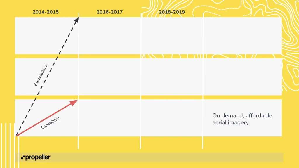
The drone market was booming down under, as Australia led the charge in UAV legalization. A greater level of accessibility got a few early adopters thinking about what automated aerial vehicles meant for topographical data collection.
Suddenly, construction sites had a way to collect progress data quickly, without subjecting their team to unsafe conditions.
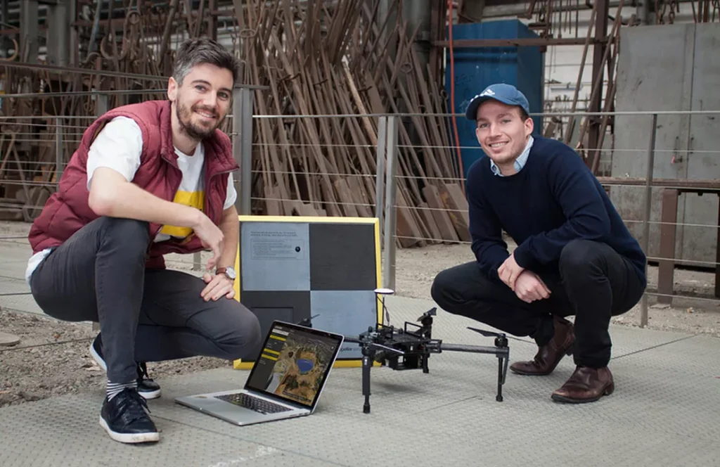
Around this time, Rory (our CEO and co-founder) met Francis (our other co-founder), and they both agreed drones would play a major part in the construction tech revolution. But there was a question of what part they’d play: were drones the machine or the fuel?
Were drones a stop gap for the speed-accuracy problem that kept surveyors overworked or was aerial data just the fuel source for an even greater workflow?
Most companies contributing to the aerial surveying space were drone service providers, exclusively focused on hardware, but Propeller’s founders were looking beyond that toward the next pain point—processing.
When they started scoping out the market and asking real people about some very real problems on construction sites, everyone told them the same thing: to stop worrying about the drone, and focus on making drone data easy to process
So, what did Propeller do? We got to work building out a software platform to process and analyze all the new data that drones were bringing in.
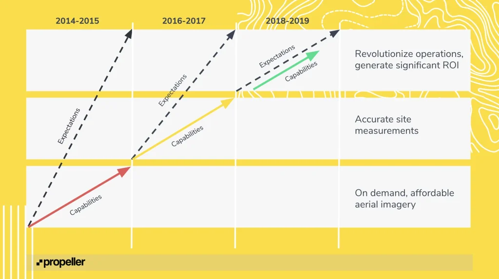
2016, Capabilities trail behind expectations (but, not for long!)
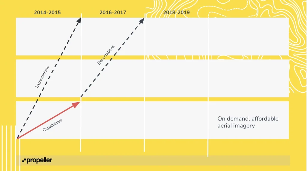
By the time 2016 rolled in, everyone had these really audacious expectations for drones—they were going to resolve the data deficit and power an entirely new generation of digitized worksites.
But the hardware and software capabilities weren’t keeping up with the growing expectations. Here’s why:
- Lots of DIY drones on the market meant lots of compatibility issues
- DJI’s Phantom was in its early days and hadn’t gone mainstream yet
- Low-quality cameras couldn’t meet accuracy requirements
- Software was mostly open-source products without industry-specific functionalities
- GPS wasn’t PPK or RTK grade
While drones and drone mapping were intended to help survey teams scale and the teams that relied on surveyors get the data they needed, there was a major bump in the road preventing this at scale: ground control.
Even though surveyors had drones to capture aerial images, they still had to walk the site with a rover and create their own checkpoints. The amount of time they spent laying ground control points negated whatever time they saved with the drone.
This is why Propeller decided to enter the hardware space. We knew there had to be an easier way to capture ground control, and we were committed to bringing that solution to light.
Ground control points get smarter, AeroPoints become industry standard
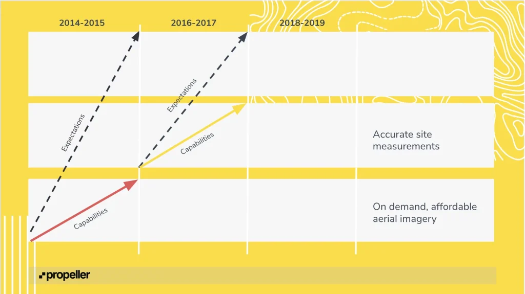
The AeroPoints prototype was something we called the “pizza box,” a rugged, lightweight ground control point that was capable of logging its location on any coordinate grid. You lay them out, turn them on, and they get to work grounding your drone data.
We tried out a few different patterns and color combinations to narrow in on a formula that yielded the most accurate results. At first we thought, “why not go for the high-contrast colors,” so naturally we experimented with black and white.
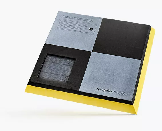
What we found is that white squares overexpose the camera and compromise image integrity. With the glare coming off the white, it was impossible to establish a middle point. Eventually, we found that adding in a touch of grey counteracts the glare and actually appears white on camera.
We even positioned a rover against an AeroPoint in an urban environment, and compared the two datasets at three different points. Even on a site with high probability of multi-path errors, the AeroPoints delivered comparable results.
Once we were out of the testing phase, AeroPoints took off fairly quickly. Because no one was using RTK and PPK drones yet, high-precision ground control hardware was a necessary investment.
HeidelbergCement became a very early AeroPoints customer, and was able to get consistent and accurate results every time they flew, along with thousands of other worksites across the .
Following the success of AeroPoints, it became time to refocus and experiment with other pain points.
The Present
Focusing on accuracy, support, open data, and surveyors.
Drone reality catches up to expectations
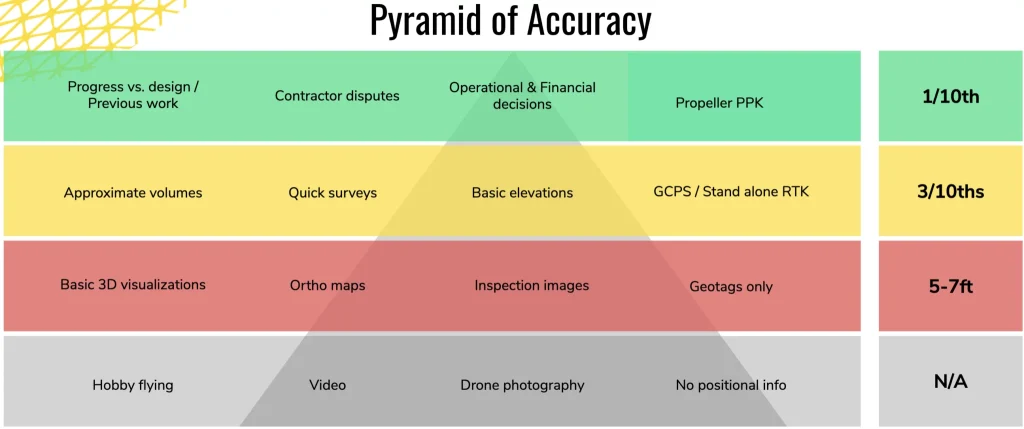
The most important takeaway: We’ve finally reached a point in the drone revolution where worksites don’t have to choose between speed and accuracy. Phantom 4 RTK is largely to thank for this shift.
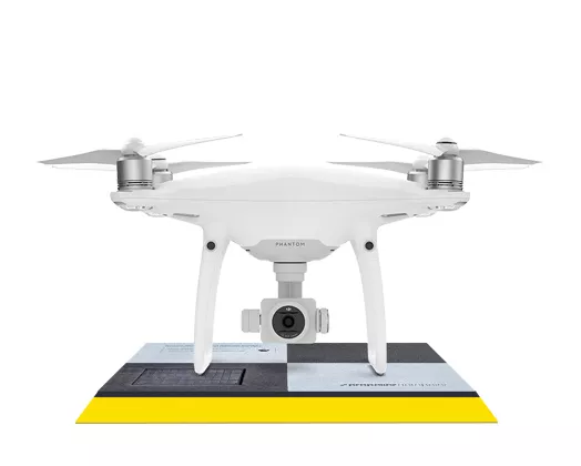
Just three years ago, there was no way to reference the data on the ground without using surveyor rovers and spending days out in the field. With the emergence of real-time kinetic tech, all Propeller customers are getting 1/10 ft accuracy easily, affordably, and reliably.
Sure, both hardware and software have matured, and for the first time, we’ve been able to deliver on expectations, but the market is still only partially invested.
Last webinar, we conducted a quick survey and found that 60 percent of attendees already had a drone on their worksite. We’d still say we’re only in the early part of the early majority stage of adoption.
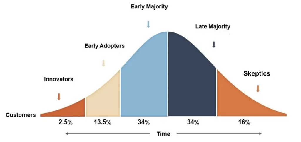
We’re currently working with around 40 companies on the ENR 400 List. If we’re gauging adoption from that, we’d estimate that the construction industry is only around 10% invested in drone mapping at this time.
In other words, we’ve come quite a ways, but there’s a long way left to go.
Surveyors are friends, not competition
The beauty of Propeller is that we’re not exclusively focused on working with those ENR 400 behemoth construction operations. That’s not who we are.
We’re trying to make life easier on the worksite for operations of all shapes and sizes, and accuracy is the cornerstone for everything that we do. And if accuracy is the focus (which it is), it’s critical for us to work alongside surveyors instead of against.
Drone technology will never replace surveyors, and that has never been our intention. We’re empowering surveyors and worksites with practical solutions to the recurrent problems they’ve always battled with.
We’re not in the field everyday, so we need strong relationships with those who are to drive Propeller forward. That said, surveyors are the catalyst for our evolution, not the competition.
How will Propeller maintain the same accuracy standards as it grows?
When most people think of cloud startups, they don’t think about human interactions, but human
checkpoints are the driving force behind Propeller processing.
The amazing group of humans on our data success and customer success teams make sure that every single customer has the resources they need to be successful and all processed datasets are QA’d to meet those high accuracy standards we set for ourselves.
We will continue to scale these teams as Propeller lands on more worksites.
What’s to blame for slow technological adoption?
The technology. Too often, under-digitalization is something we blame on the industry. We hear about construction’s resistance to change all the time, but never do we talk about how most of the technology available to worksites is still in its early form. Early days almost always mean unreliability.
Unfortunately, productivity hasn’t grown in parallel to digitization because everyone is running into data silos. To really put the siloed data problem into perspective, we can think about the fragmented nature of mature telematics.
Heavy machinery is an indispensable piece of every earthwork operation, but each machinery manufacturer is building their own telematics system, which makes for an incredibly distributed network of technology.
The machinery can’t work together as it should because it’s all calibrated to a separate system, and the customer is left with a mess of incompatible information. When we have a diverse mix of technology trying to accomplish the same thing, we wind up buried in data silos that inhibit productivity.
We’re working alongside Trimble and Komatsu to avoid contributing to that void. Open data is what Propeller is built on today, and our plan is capture more and more of that data, while maintaining the same level of transparency.
The Future
Bridging the gap between office and field
Right now, we’re seeing a shift in how people use Propeller and drone analytics, and that shift has created two distinct user mindsets:
- The first mindset is, “I’m looking for really accurate drone data in a cost-effective and scalable way,”
- and the second mindset is asking, “how can I unlock a greater level of productivity on my worksite with this data?”
We’re going to be nurturing both mindsets moving forward, and arming every customer with the tools they need to be successful.
But, at what point in the drone program experience do worksites make the shift from just site surveying to wanting to apply all that data to better their site? It’s a learning curve.
First, businesses need a way to combat collection issues associated with accuracy, hardware, coordinate systems, and drones.
Next, you have all this data you’ve collected and need a scalable way to process it. We’ve given worksites a way to leave all the self-processing woes behind and still get usable data, faster.
And, we’re getting faster at processing. Recently, we had a job come in with 850 images, and we were able to get the processed survey back to the customer in just two and half hours. We typically advertise that we’ll have your processed data back within 24 hours, so this is quite a significant turnaround.
After you’ve nailed down collection and processing, you start craving ways to apply the data. This is where our in-platform tools come in. Within the Propeller Platform, you can measure road grades, stockpiles, progress to design, what you’ve accomplished so far, and what’s left to do.
It’s after those measurements and deliverables start rolling in that the split occurs. Because at that point, site surveying is operating like a well-oiled machine. Once the workflow is tried and true, some users push past into site management territory.
How can you use Propeller to manage your site?
Effectively managing a worksite boils down to accountability and keeping everyone informed. Propeller supports an unlimited number of users per site, and you’re able to change the level of permission for each added user.
If everyone on site, regardless if they’re in the office or in the field, can login and see how the project’s progressing, the worksite stays connected and informed.
NZ Transport Agency and Northern Express Group (NX2), one of Propeller’s existing customers, is using Propeller as a worksite management solution right now. Because Propeller is shared among 120 people on site—surveyors, engineers, geotech professionals, and more—everyone can get the answers they need without having to take someone else away from what they’re working on.
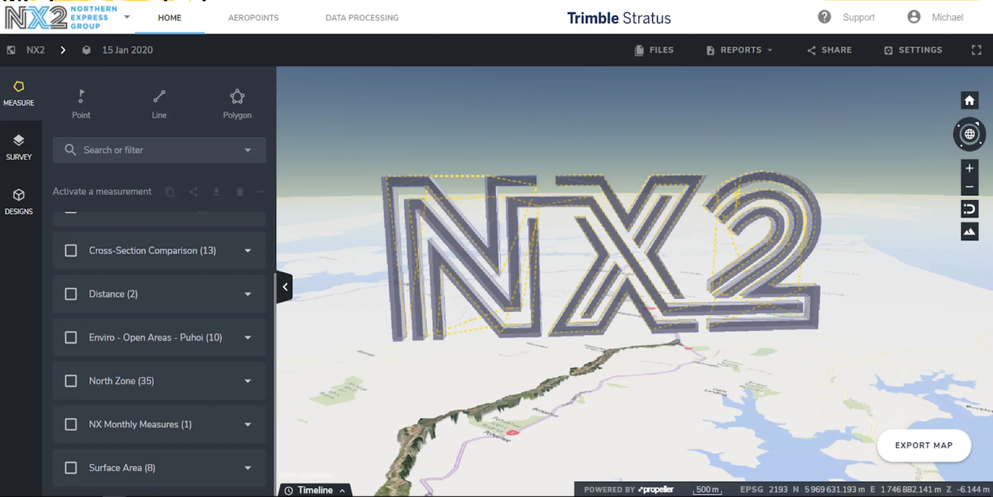
You can read NX2’s story here.
The next iteration of this workflow is to try and help these maps that our customers are using, analyze themselves in some automated way. That kind of analysis requires more data.
Moving beyond drones
There’s no question of whether drones are a critical part of Propeller’s story, but there are many scenarios where they fail and require a ton of manual work to rectify.
We want to make sure there are other ways to collect data, outside of drones, that feed into the Propeller Platform.
Propeller’s future will be a slight departure from our history, but will give us the power to redirect the construction management road in a new direction.
And we’ll tell you this—it’s a direction you’ll certainly want to be a part of.


