
When you’re using cut/fill maps to calculate remaining airspace on your landfill, you know that even small deviations in cost estimating can snowball into big margins of error when applied over your whole site. This can cause variances in your budget. Unsurprisingly, getting accurate quantities is one of the most important tasks when it comes to surveying on site.
No matter what industry you’re in, you’re likely using cut/fill maps for your landfill in one way or another.
In the waste management industry, what others might think of as cut/fill volumes are airspace calculations and provide a method for finding your compaction rates.
Landfills get paid per ton of waste. With a set amount of airspace you can fill, the amount of waste you can get into that airspace defines the performance of your landfill—this is the compaction rate.

If you have a weighbridge, drone, and access to Propeller, you can easily measure your compaction rate and calculate your remaining airspace every time you fly. It’s as easy as drawing or importing your cell boundaries, comparing volumes between different surveys, turning on the on-screen density calculator, and adding in weighbridge data.
But that’s just one way cut and fill calculations play into landfill and cell management. Another way is during the high-cost building of new cells. A huge undertaking—both physically and cost-wise—for a landfill and often involving many contractors.
When you are surveying via drone you can do so more often at better cost, thus getting more up-to-date data. Similar to other industries, being able to track accurate volumes of earth moved allows you to better track contractor work and ensure that you’re being charged for the work that was actually completed.
Let’s start with airspace and compaction, two of the most important numbers on any landfill.
Find remaining airspace in seconds
When it comes down to it, you just need to know how much airspace is left. Whether it’s for a specific cell or your entire landfill, but too often isn’t accurate enough when using traditional surveying methods. When compaction-rate estimates go awry, not knowing can cost you big.
Aside from the drone surveying benefits gained from having up-to-date information more frequently, with processing platforms like Propeller you can calculate remaining airspace in seconds. It’s just a matter of a few clicks.
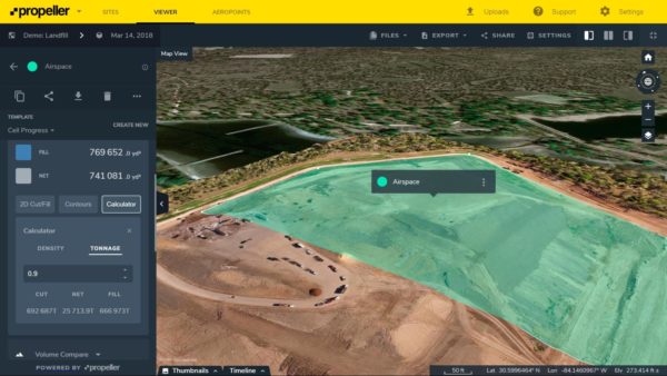
To make this calculation even more useful, you can also upload top-of-waste design. Easily view your site today compared to its TOW, all in 3D. With these parameters, spot where you’ve overfilled.
All the relevant numbers are automatically calculated, and display on the calculator on the left-hand side of your screen.
Track landfill density accurately and quickly
If we’re talking density, you can also use drone data and a processing platform to calculate compaction rates and densities in a fraction of the time. Easily compare rates between surveys or with the design itself, then add in weighbridge data, and let Propeller do the math.

Similarly, when you fly frequently, you build up a visual history of your landfill. This drone data timeline lets you see and measure settlement over time and place. Is one part of your landfill settling faster than the rest? Drone imagery rendered into a measurable, 3D site visualization makes it easy to spot that—and communicate it to the people who need to know.
Monitor landfill productivity and quality
Of course, knowing how you’re faring against top-of-waste design is a big focus. To describe an entire landfill, you would usually need to walk multiple lines across the waste, use those points to interpolate an approximate elevation model, and then compare that model against the TOW design.

In Propeller, this workflow is significantly shortened: you can simply upload your TOW design. This gives you an overlay on the 3D site survey, which instantly highlights how you’re progressing. It takes the guesswork and abstraction out of the process, and lets you have a visual conversation with your team or your boss.
Each of the measurements we’ve been talking about can also be individually exported in to reporting formats for your monthly or quarterly reporting. Having this data up-to-date, easily readable, and linked together on a site timeline allows for better landfill management.
Cut and fill software helps at every stage of landfill management
As we’ve seen, having accurate numbers on hand means thoroughly tracking remaining airspace, maximizing compaction rates, and getting your whole team on the same page. When you need to relate these calculations, platforms like Propeller have easy-to-use reports in both CSV and PDF.


