
Drones cut down surveying times to hours instead of days or months, and they’re cheaper than traditional survey equipment. There’s a whole lot more that drones can do for mining, however. Let’s look at workflows to see how you can use your data to best effect.
Stockpile management and reporting
Stockpile management is the most widely used worksite application for drones. This is for good reason: drones have completely transformed this common workflow. The old days of “walking a stockpile” are surely numbered.
With a drone, you can now capture an entire ROM pad in less than 30 minutes. Within a processing platform like Propeller, getting accurate volume calculations and comparisons takes just a few seconds, with all your measurements easily exported to CSV files or PDFs.

Because surveying stockpiles via drone is so much easier and quicker than traditional methods, gathering data more frequently is no longer cost- or time-prohibitive. You can fly your site as often as you want new data. You don’t have to wait for a biannual aerial flyover or an outsourced surveyor walk your site. With more up-to-date information, you can improve run-of-mine management and ensure more consistent grades through the mill.
The surveying process overall is also safer. Drones remove the risks that come with having personnel physically moving around the worksite.
Even if you stopped here and just used drones for stockpile management, you could make a good business case for introducing drones to your mine. But there’s much more you can do with this data.
Streamline planning and building
Drones can also help with the planning and building side of things. With accurate and up-to-date data, your processing engine can create a visualization of your site. This allows for better pit and waste dump design and management.
With regular flights, you build up a visual record of changes over time, which permits you to check weekly or monthly pit volumes and compare the current surface against previous datasets.
Additionally, by overlaying KLM design files on a 3D survey within a platform like Propeller, you can check the conformance of the actual site and determine the exact volume of material that needs to be extracted or moved to meet the design.
You can also model sediment flow with elevation maps, which let you better plan tailings basin operations.
Save time on drilling and blasting
Any area you’re thinking of blasting can be easily and inexpensively surveyed by drone. The data you capture preblast includes rock-type variation in a bench, face angles, rock condition, and, of course, volumes.
When you processing that data into a 3D survey, you can use a platform’s measurement tools to calculate drill depths accurately and analyze your blast area. This means getting better estimates on what a particular blast with yield before you drill a single hole. With accurate estimates, you can plan better down the road on how many trucks you’ll need, etc.
You can survey again after the blast, too. This lets you measure postblast volume and provides a picture for visual assessments of blast results, like muckpile shape, back damage, and distribution and fragmentation.
Monitor roads more efficiently
On an active mine, your roads take a beating and road quality can change quickly. Because you can get surveys more often with drones, assessing haul road conditions on a frequent and regular basis can become the norm. Not to mention better traffic planning.
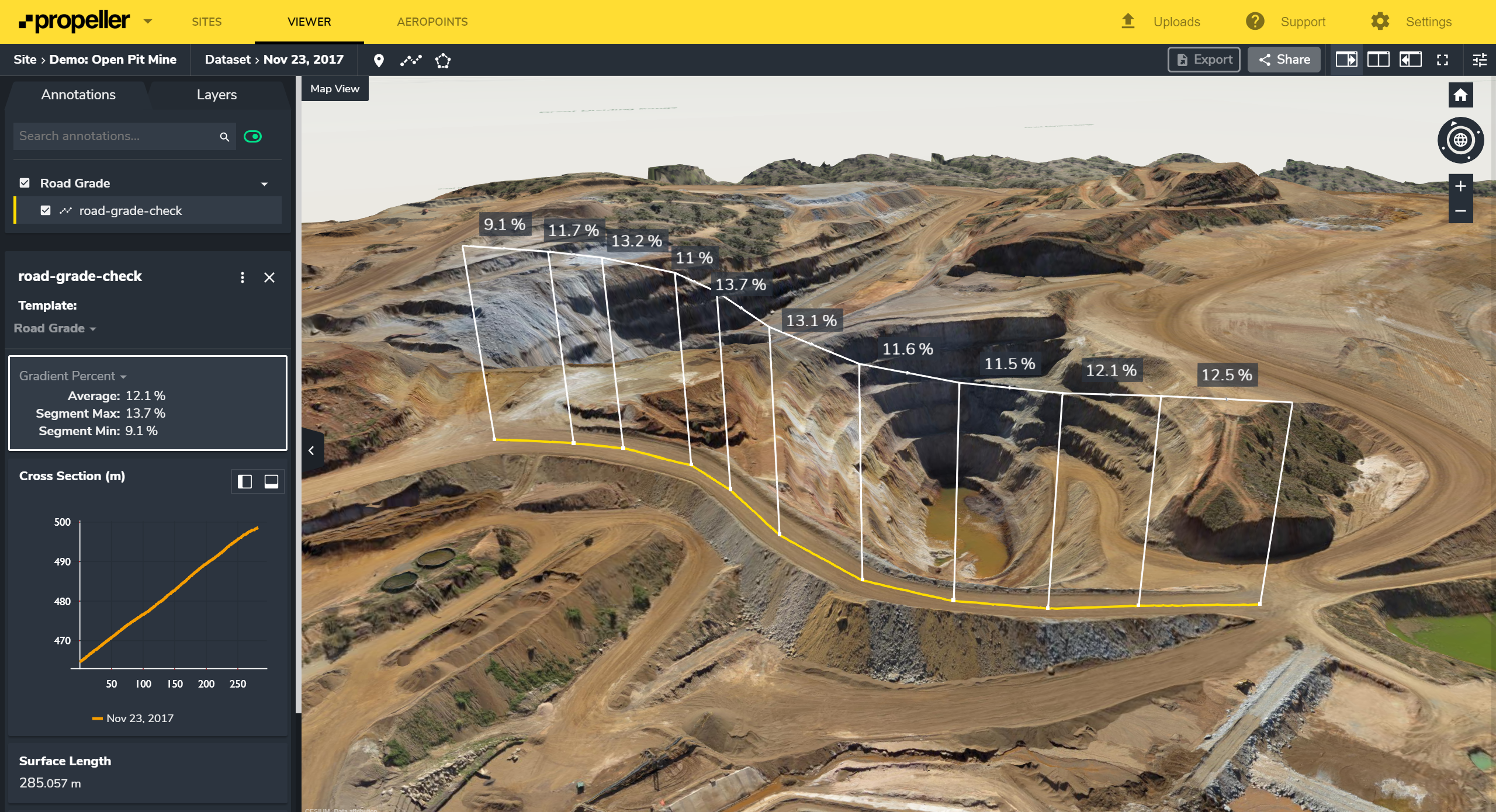
And that’s just the visual inspection part of things. In processing platforms like Propeller, you can measure road lengths, slopes, grades and check roads against design and safety requirements with just a few clicks.
Now, you know that being able to do all this quickly and accurately increases your mobile plant efficiency and reduce cycle times, but too often with traditional methods it just isn’t possible. Drones help close that data gap between what you know you need to do and what you can do.
Perform inspections more safely and easily
Perhaps most obviously, drones are great for getting eyes on hard-to-reach places. They can go where humans cannot. This makes them terrific for both safety and asset inspections. The high-resolution images they take capture details and aspects that may not be visible from wherever you are on the ground, and these can be used by multiple departments in a variety of inspection workflows.

Since you’re taking surveys over time, you can build a timeline of the life of your mine. This helps with monitoring site boundaries, especially when it comes to environmental protection. You can track and mark off spaces that should not be disturbed. And because you can grant access to the visualization to others on site, it’s easy to show everyone where the no-go zones are.
On the most basic level, drone surveys are made up of individual images. These snapshots can also help with various workflows. For example, geologists can view individually and do accurate geotech mapping and rock face inspections.
Further, because everyone is working from the same images, the same data, drone surveys provide a single source of truth across departments and sites. With various permission and sharing capabilities in your platform, you, your team, and different departments can access all the data they need, without second-guessing its accuracy. You can be confident that everyone is on the same page.
Check safety compliance easily and more often
Safety is the number-one priority for any mine. As you might have guessed by now, drones can help improve that too.
First, there’s the immediate benefit of reducing job hazards for your people, like we mentioned above. When you use a drone to perform remote surveys and inspections of potentially hazardous locations like the bottom of the pit, block caves, and heavy traffic areas, you don’t have to send in personnel to see what’s going on. Everyone’s out of harm’s way.
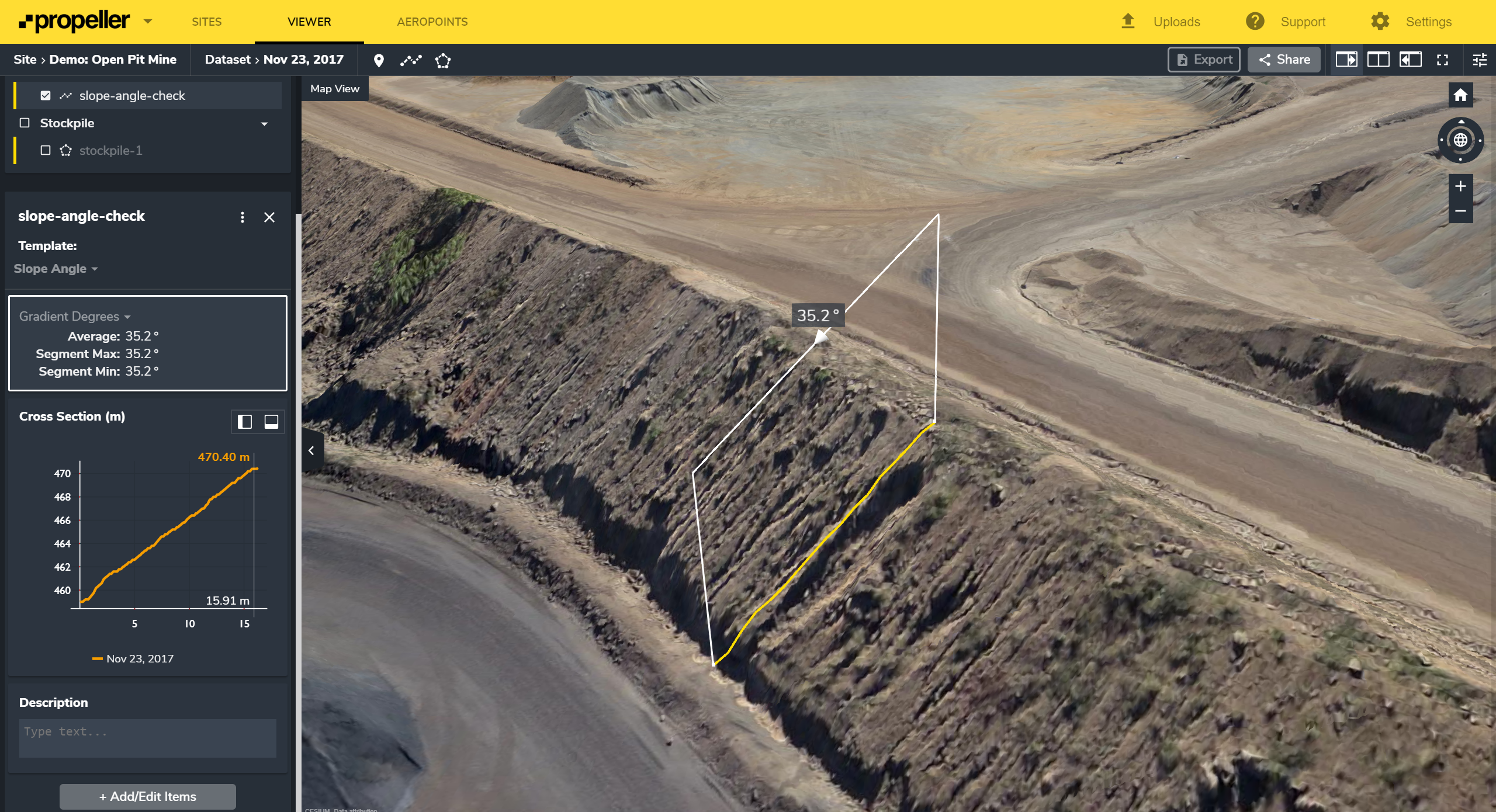
Second, you can ensure better safety planning and risk detection. This is possible because drone-captured data helps you better spot and monitor worksite hazards. You can make sure your site is safety compliant by checking windrow heights, berms and tailings dams, and measure overall pit slope or individual slope angles.


