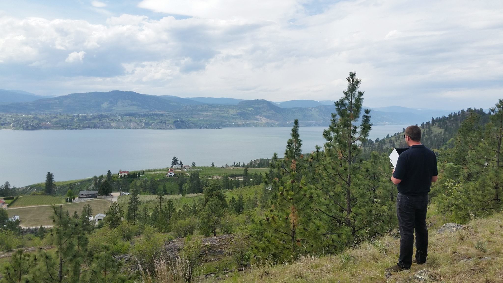
From construction site surveying to mapping and progress tracking, drones provide faster and more reliable data compared to traditional methods. This article explores how drones are used in construction and the key benefits they deliver across modern projects.
Across the business world, industries have steadily improved productivity through innovation and the adoption of new technologies that get jobs done more efficiently and with less expenses. Construction in comparison, has largely remained the same in its ways and has lagged behind other industries in the adoption of technologies that help to improve productivity. According to a McKinsey report, on a global scale, the construction industry and related spending accounts for 13% of the global economies GDP. While other sectors have steadily improved productivity at significant levels, the construction industries annual productivity growth has increased by only 1% annually over the past 20 years. McKinsey identified seven areas that could be used to increase construction productivity by up to 50%-60%. Among them was the infusion of more technology and innovation into the construction industry. Drones impact on construction is a perfect example of an innovative piece of technology that can significantly improve construction project timelines while reducing the need for capital investment and skills requirements.

What are the benefits of using drone surveying in construction?
The benefits of drone surveying for construction companies can be grouped into 4 major categories. Increased efficiency, reduced expenses, improved safety standards, and improved data accuracy.
- Increased Efficiency
- Reduced Expenses
- Improved Safety Standards
- Improved Data Accuracy
1. Increased Efficiency – Anyone who has ever been through the process of manually surveying a construction site can tell you that it is not an easy process. It takes time, a workforce with a particular skill set, money, and a willingness to redo the survey if anything goes wrong. Approximately five acres can be surveyed per hour with traditional methods. With drone surveying, even beginner surveyors are capable of surveying 120 acres per hour for a 60x improvement in surveying efficiency. For a company with 10 different 120-acre sites that they want to survey 5 times per year, traditional surveying for each site would require 24 hours of work, taking 120 hours per site, per year. Across all sites, this would require 1,200 hours of work annually.
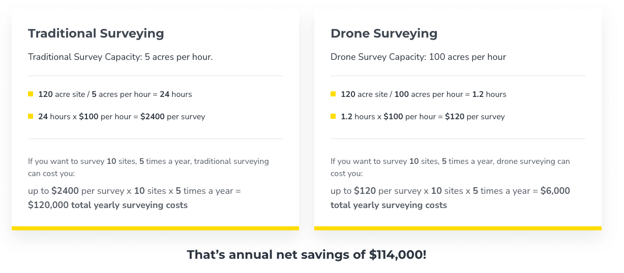
Drone surveying in comparison is capable of completing each of the five annual site surveys in one hour each, taking only five hours per site. Across all ten sites this would only amount to 50 total hours invested to complete these surveys. Drone surveying significantly reduces the total time investment needed to survey a site. But one of the other benefits of this increased efficiency is that on a construction site work is nearly always being done across many areas.
Keeping track of everything is difficult and for many companies chaos can become the norm. With traditional surveying, larger construction sites can require multiple work days to finish, in that time there’s no telling what has changed since the survey started. This often requires re-surveying and can severely delay the beginning of new work that could get in the way of the surveyors. In a perfect world, the differences in efficiency between traditional surveying and drone surveying would remain the way it is presented in a purely numerical sense. But construction is an industry where things rarely go exactly to plan, when unexpected delays and problems emerge, the inefficiency of traditional surveying can compound and cause further issues down the road. The increased efficiency, accuracy, and adaptability of drone surveying helps to make sure construction companies can deliver more projects on time and within budget.
2. Reduce costs – As mentioned earlier, traditional site surveying requires a much larger time and manpower investment to complete the survey. With those extra hours and surveyors comes salaries, equipment, and all the other expenses that come with construction work. Looking at salaries alone and assuming a traditional surveyor works for $100/hour and a drone surveyor works for $120/hour the savings can still be substantial. Even with the higher hourly rate the drone surveyor would only be required to log 50 total hours of billable work per calendar year for a total cost of $6,000 of annual surveying fees.
In comparison a traditional surveyor would require the aforementioned 1,200 hours of work. These 1,200 billable hours of work would require a total surveying cost of $2,400 per survey and $120,000 worth of total annual surveying fees. In total drone surveying is capable of saving $114,000 dollars in drone surveying fees compared to traditional surveying for a relatively small company needing to conduct 50 surveys annually. Needless to say, for larger companies these savings would only increase, and this assumes that everything related to surveying goes according to plan and does not require any rework. The different projects that could be used to calculate expenses could involve a multitude of different assumptions, but any serious look at the data regarding drone surveying compared to traditional surveying will acknowledge that drone surveying is incredibly effective at reducing time and expense requirements to ultimately make drone surveying an incredibly effective way for construction companies to reduce variable expenses.
3. Improved Safety Standards – Construction by its nature involves work that can be dangerous. Surveying is no different from any other part of the construction process. Traditional surveying often requires workers to enter difficult-to-reach positions on worksites with many moving pieces. To impart the value of safety in a construction company, it’s necessary to go beyond simply treating safety as a checklist item to be taken care of to keep a supervisor off your back. Changing work practices to reduce the total risk that workers are exposed to is an essential part of producing better safety outcomes.
Reviewing site maps and data obtained by drone surveying can be done from the comfort of an office or any area of a worksite without ever having to expose workers to significant bodily harm. Across the construction industry falls account for 34% of workers fatalities on construction sites, and 1 in 5 deaths among US workers is in the construction industry. Not only is drone surveying helpful for keeping workers out of harm’s way, but the data can be more accurately and efficiently gathered through drone surveying and can be used to spot potential hazards on a work site before they cause problems.
Of course, the main benefit of increased safety standards is the avoidance of injuries but safety also has a huge effect on a company’s bottom line. In the US, fatal construction injuries are estimated to cost $5 billion each year in health care, lost production, reduced quality of life for family members, and lost income. Any construction company that is serious about improving safety has to consider updating their surveying process to include drone surveying.
4. Improved Data Accuracy – The process of collecting data with drone surveying is called drone photogrammetry. In simple terms, drone photogrammetry is the process of measuring real-life distances from overlapping photos that take into account all different angles and perspectives. The process may sound complicated but when done with a drone it can be completed quickly and with a degree of accuracy that is difficult for traditional surveying to match. In a single surveying flight, drone data processed with surveying software like Propeller can produce a full map of the surveyed site with accurate measurements of distances, surfaces, elevations, and volumes, and provide GPS points represented in either two or three dimensions.
Quick, accurate, and cost-efficient drone surveying can be done as often as necessary, and it provides the ability to analyze the data with a cloud-based software platform like Propeller. Drone surveying also ensures that all project stakeholders from subcontractors to off-site work teams can have access to the data in an easy-to-understand format to ensure the entire project is progressing on time and according to design.

Having the right information at the right time across multiple, separate parties goes a long way to ensure that projects can come in on time and within budget.
Across the construction industry rework, conflict resolution, and looking for unavailable project data costs construction companies $177 billion annually. Propeller’s drone surveying program for construction companies can ensure that all your surveying data is processed correctly and quickly, ensuring accountability, communication, and collaboration to deliver the highest level of performance possible.
What do construction companies use drone surveying for?
Construction companies can use drones in many ways, but generally, the use cases fall into five major categories. Site analysis, planning and design, asset inventory, project reporting and collaboration, and resolving disputes. Drones impact on construction:
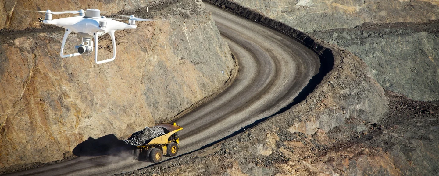
1. Site Analysis – The most obvious and wide-ranging use of drone surveying for construction companies is surveying the construction site itself. This is typically the first step of any construction earthworks project, but with the increased speed and ease of using drone-based surveying, site analysis can be completed more regularly to ensure up-to-date data.
This data can help ensure the progress of the project across multiple teams is actively monitored and can be relied on without having to waste valuable time and capital waiting on results from base and rover surveying methods. Anyone with experience in the construction industry knows that the surveying requirements from project to project and from day to day are constantly changing.
A Propeller client, Haskell Construction, managed a particularly large job that required multiple surveys per week to verify information across a multitude of different subcontractors working on an interconnected project that could grind to a halt if a single aspect was out of place. So while the outputs of drone surveying are similar to traditional surveying, the speed, accuracy, and price of drone surveying have completely changed what construction companies can expect from their surveying program.
2. Planning and Design – Drone surveying mixed with a fully-featured surveying software like Propeller enables teams across projects to use 3D site imaging to compare designs and as-built documents to work that has been completed. Going beyond simple comparisons, these tools can also be used to plan out major project elements and ensure that all plans for the project are in line with expectations before work begins. Using these 3D models, construction companies can give virtual walkthroughs of project plans, show progress, spot hazards before they can cause delays, and, as we will cover later, resolve contractor disputes. While the main use case of drone surveying will always be the site mapping and measuring, when a construction company has access to a software like Propeller the use cases of drone surveying expand to include elements like planning and design modeling.
3. Asset Inventory – Drones’ surveying capabilities can also be used to keep track of smaller, more specific assets for construction companies. Drones can be used to complete inventory assessments while providing a larger level of detail and reducing time and cost requirements. This can significantly diminish the danger involved in completing inventories that require workers to approach difficult-to-reach spaces that drones can easily access. On larger earthworks or mining projects, drones can be used to quickly calculate accurate stockpile inventories that ensure enough building materials are available to get jobs done. For many companies, stockpiles represent a significant financial asset, the ability to know with a high degree of accuracy how many resources you have available is very important for long-term planning and assumptions. When measuring these stockpiles, they often go through daily changes that can be difficult to keep track of with traditional surveying methods.
Beyond this drone mapping software like Propeller can render all the information in easily understood 3D models that display volumetric measurements. When surveying stockpiles their irregular shapes often create an increased amount of difficulty. In situations like this, the digital capabilities of drone surveying can shine. Compared to traditional surveying digital drone surveying with software like Propeller can quickly and easily take into account all the irregular contours that many stockpiles have that can cause inaccuracy and require a much larger time investment than traditional surveying methods or even more modern surveying methods like base-and-rover surveying which is typically more expensive then drone surveying. When measuring these stockpiles the information can be applied in wide-ranging ways that affect things like taxes and company expenses so even a single inch or two of inaccuracy can be a big deal for construction companies.
Another benefit of Propellers stockpile reporting in particular is that we charge by dataset instead of by the pile. In comparison, other companies usually just return a report without visuals of any kind. Propeller can survey your entire site and return an interactive 3D survey that can be used time and again and be easily updated. Across all industries, both inside and outside construction, measuring stockpile volumes is the most common use of drone surveying. Many companies are using drones with new technologies like optical barcodes that can be scanned with drones to keep an up-to-date, accurate inventory of tools, heavy equipment, resources, and a wide range of other parts that go into large-scale construction projects.
4. Project Reporting and Collaboration – Highly detailed and easily accessible project documentation has advantages for all stakeholders. As mentioned earlier, any significant construction job will involve collaboration between multiple external subcontractors whose main focus is on their section of the project. Without proper communication between these teams, it’s easy for all the moving pieces to not connect correctly.
A software solution like Propeller provides easily accessible 3D models, visualization tools, and collaboration tools so that all elements of a project can be seen in conjunction with one another. This helps subcontractors understand the scope of the project and how each of their individual projects contributes to the overall job. Another element of these reporting features is mobile and remote accessibility. Across field, warehouse, and back office teams, this data can easily be accessed to ensure everyone has up-to-date information to make informed decisions to advance the project.
5. Resolving Disputes Haskell is a construction company that provides services across the construction industry. Hamzah Shanbari, a technology and innovation manager on a Haskell team working on a particularly large project, monitored the work of dozens of separate subcontractors working independently. As a part of his job, Hamzah was responsible for verifying that the separate subcontractors had correctly completed their pieces of the project. Due to the pace of work, Hamzah was required to survey the site twice per week, which was impossible using traditional surveying methods. However, using drone surveying and Propeller, Hamzah could visualize work site progress twice per week with up-to-date data, 3D site imagery, and design files of all the subcontractors work. When checking the work of an underground services contractor, Hamzah and his team identified that conduits were placed incorrectly, impeding the progress of another subcontractor and the project as a whole.
Using this information, Hamzah was able to prove that the subcontractor was off in their work, requiring them to redo it so it matched the originally agreed upon, as-built conditions. Had Hamzah and his team not had this accurate information available, the dispute with the subcontractor could have dragged on for weeks, costing Haskell precious time and money in the process. When speaking about his experience using Propeller, Hamzah said “Propeller makes it easy for us to monitor the work happening on the worksite and make sure everything is being done as designed and modeled. The level of visibility drone surveys provide allows us to identify issues quickly, before they become expensive problems. If I was to describe Propeller in one word, it’d be fantastic!”
How are drones changing the construction industry?
Across the construction industry, companies use drones in slightly different ways, but in general, they have already improved project reporting clarity, project timelines, and the inspection process to deliver a faster, more efficient, reliable construction operations process. Even though they are a relatively new technology, drones have already had a significant impact on changing the construction industry. Expectations around surveying and project timelines have been significantly raised, and more accurate and accessible data has made communication and dispute resolution easier between external teams that can sometimes be at odds with each other.
1. Clarity
Any significant construction project tends to involve multiple subcontractors who are hired to complete specialized tasks that are a part of the larger project. Some subcontractors are more focused on finishing their part of the project, without keeping the bigger picture in mind. With the digital files and project updates that drone surveying and Propeller provides, project managers receive a new level of clarity and reporting accuracy to monitor the project progress as a whole more closely.
This increased accuracy and more comprehensive reporting allow construction companies to keep detailed records without having to rely on costly and time-consuming traditional surveying methods that could potentially lead to project delays and increased variable expenses. With this added benefit, conflicts can be more quickly resolved and clarified to avoid project mismanagement and delays with drone survey data. With this improvement many companies can continue to manage their reporting requirements on the fly and reach critical decisions on any conflicts that help to avoid major project delays and miscommunications.
2. Improved Timelines
Accurate data is essential to the planning process of any major project. With traditional surveying, data can be gathered but it often comes in slowly and requires everything to pause on site to achieve the highest level of accuracy possible. With drone surveying the speed and accuracy of surveying are significantly increased, which enables a much quicker and better-informed decision making process that can significantly reduce project timelines. This also significantly reduces the amount of confusion when tracking project progress and verifying different project elements are correctly in place. The increased efficiency, accuracy, and security that drone surveying provides has already gone a long way in the construction industry to improve project timelines and ensure that clients’ expectations are consistently met.
3. Protected Areas
Technology, like drone surveying, can play a key role in promoting and advancing environmental sustainability in construction. When worksites function efficiently, projects not only progress with fewer errors, but they also produce less waste. This makes for a more environmentally friendly construction process, benefitting both the business and the local surroundings. Drone surveying and processing your data through the Propeller Platform allows you to identify protected areas easier and proactively address impact on natural resources (e.g., wildlife migration corridors, natural water drainage features, protected forests).
Case study: Petillo Inc., an excavation and site contractor in the greater New Jersey area, worked on a two-phase project where they were required to keep all of the material on-site for environmental reasons. This 500-acre job site was once used to cast giant motors for boats and airplanes, and after years of ongoing production, the process tainted some of the soil on the site.
Employing drone surveying with the Propeller Platform, Petillo was able to track where the dirt moved on site and develop stockpile reports with accurate yardages that told them the original location of soil. They could then report this information back to the New Jersey Department of Environmental Protection, who was closely tracking how Petillo dealt with the impacted soil.
What you need to implement a drone surveying program?
Implementing a drone surveying program on your worksites might sound complicated, but there are only three key pillars to focus on when you’re getting started:
- Training and certification
- Drone Hardware
- Mapping Software
1. Training and Certification
Drones may be small, but they’re still a type of aircraft. Your country’s aviation authority regulates all unmanned aerial vehicles (or UAVs). The location of your worksite can determine how, when, and if you fly, depending on the airspace overhead.
U.S. commercial drone regulations are managed by the FAA, which requires a Part 107 Remote Pilot Certificate to fly. Critical aspects of drone operation include keeping drones within visual line of sight, flying below certain altitudes, and maintaining specific safety standards when flying over people. Getting your Part 107 license requires some coursework and an exam, but the process is easier than you think. The test consists of multiple-choice questions covering key aviation terms, weather considerations, and regulations pilots must know. Most of these answers are intuitive.
Australian commercial drone regulations are a bit different. Pilots need either an RPA operator accreditation or a Remote Pilot License (RePL), which involves taking an official course and assessment. If you’ll be flying a drone larger than two kilograms, the RePL is required regardless.
European commercial drone standards are also unique. The European Union Aviation Safety Agency (EASA) recently replaced each member country’s existing laws relating to drone operation with a unified set of standards, making it easier to operate drones across the 28 EU member states plus Iceland, Switzerland, Liechtenstein, and Norway.
Both the U.S. and Australia require pilots to register their drones, which is effectively like getting a license plate to identify your aircraft. For more detail on region-specific requirements, read our overview of commercial drone regulations in the U.S., Australia, and Europe.
2. Drone Hardware
Once you’re licensed to operate a drone, you’re ready to turn your attention to the drone itself. The drone you choose is important because it directly impacts the quality of data you collect in the field. Be sure to select a drone and camera setup that will collect the highest quality images based on your budget. Before making your decision, consider that small errors in mapping can negatively affect your surveys, so it’s important you determine the degree of accuracy and detail you need before selecting a drone.
At Propeller, we’ve partnered with quality drone manufacturers to bring you a range of options that complement our platform and workflows, including but not limited to:
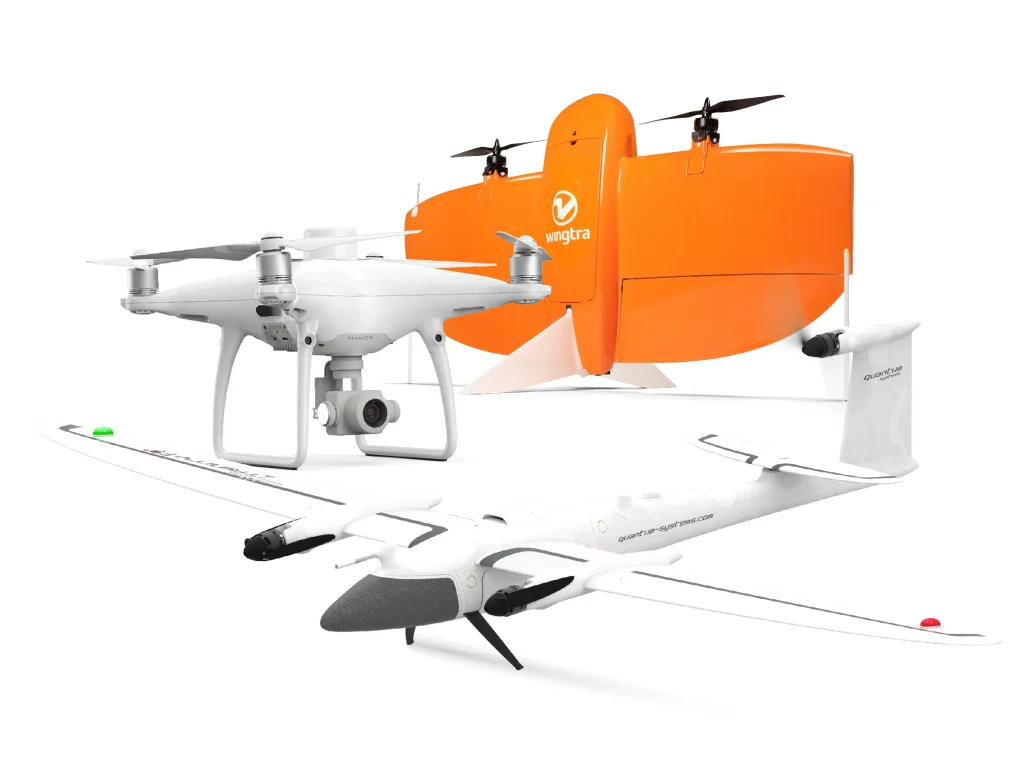
- DJI Mavic 3 Enterprise
- DJI Matrice 300 RTK
- WingtraOne VTOL GEN I and GEN II
- Quantum Systems Trinity F90+
For a complete list of recommended and compatible drones, check out our online guide here. We’ll also take a deeper dive into the different kinds of drones, and the pros and cons of each, further down this page.
If you’re worried about operating your drone, don’t be. Apps make the process of flying a breeze. Setting up your drone’s flight path takes only a few minutes. Once that’s done, simply hit go and monitor for air traffic from there—no manual control involved.
Ground control
You can use manual ground control points (GCPs) in a drone surveying workflow or add smart ground control like AeroPoints for a seamless, end-to-end surveying solution.
AeroPoints take the manual effort out of ground control, providing a critical on-the-ground reference point for high-accuracy data capture without the hassle of manually marking and moving points as work progresses.
With Propeller PPK, you only need one AeroPoint to serve as a combination GCP and base station on most worksites up to 100 acres. You can complete a drone survey using AeroPoints as your ground control in just a few simple, efficient steps:
- Place your AeroPoints on the ground nearby and turn them on
- Initiate your pre-programmed drone flight, and fly your site for at least 10 minutes.
- Connect to a wifi network to upload your aerial survey data
Bluetooth and wifi-enabled technology allow AeroPoints to communicate directly with your drone hardware and mapping software, so all the legwork is done for you in the cloud. To learn more about AeroPoints, check out this post.
3. Mapping Software
With the right mapping software and the proper training, you can read your drone survey data results and make informed decisions within your construction operations.
Advanced mapping and analytics software assembles thousands of drone images into a three-dimensional map of your worksite. This map isn’t just visual; it’s rich in data, including elevations, distances, and GPS coordinates. The Propeller Platform allows users to track the progress of any project over time, calculate stockpile volumes, check road grades, monitor environmental zones over time, track compaction rates and remaining airspace for waste management cells, and so much more.
Make sure you invest in the right software for your needs. Some are optimized for agriculture, while others (like The Propeller Platform) are purpose-built to meet the needs of civil construction contractors. You can track progress and productivity on-site, measure quality, and mitigate cost with simple tools anyone can use—all from the cloud.
When vetting the right survey software for you and your team, here are a few questions about your business that you’ll want the software solution you choose to answer:
- How accurate are the 3D models generated?
- How is that accuracy ensured/verified?
- How is data processed after a drone flight, and who does the processing?
- How can I be confident in the measurements my software provides?
- How can I estimate my construction earthmoving volumes more accurately?
- What types of reports are available in the software to aid in my decision making?
- What data can I share with key project stakeholders and how easy will it be for them to access the information they need?
Potential problems with drones in construction
Any technology tool is only as good as your ability to use it, and drones are no exception. When it comes to drone surveying workflows, here is where we most often see teams run into trouble.
Manual flights
Automated drone flights work best, as manual flights can introduce errors. Automated flying provides steady, consistent flight, which is crucial to gathering high-quality images. Low-quality images yield low-quality survey data, so automated flights help pilots in more ways than one. We would recommend that most companies avoid using manual flights unless some special circumstances require it. The increased risk of errors is not counteracted by enough benefits to justify it in most situations.
Airspace regulations
Research restrictions on your local airspace before investing in a drone program. If you’re close to an airport or other restricted airspace, you may find that you cannot legally fly a drone where, when, or how you’d hoped. A bit of up-front mission planning can help ensure the long-term success of your drone surveying program. Most countries have different sets of rules so doing some research online for your specific area is usually the best route to avoid accidentally breaking rules you were not aware of. In general the most common occurrence of this being a problem is people flying near airports or any government restricted airspace, just make sure to check your local regulations before flying.
Self-processing
We highly recommend choosing software that will automatically process the data your drone collects, using smart ground control and other checkpoints to augment manual QA. Choosing to self-process your data will tie the results of your flights to the work of a small handful of qualified individuals, creating bottlenecks and aging the survey results before anyone can use them. As well most modern drone surveying softwares like Propeller have safeguards in place and specific personnel like our customer success engineers whose sole job is to make sure that our customers are given the resources they need to accurately and effectively take advantage of all of Propellers capabilities. Similar to manual flights there really is not many incentives to self-processing data relative to the risks that it introduces.
Data silos
Another potential problem with regularly collecting site data is that the right people won’t see it in time, or at all. Choose a cloud-based solution that opens up access to anyone who needs to see survey data as soon as it’s available, from project managers and engineers to subcontractors and clients. Across multiple different departments and sometimes multiple different subcontractors, worksite communication enabled by cloud based solutions like Propeller can be the difference between a smooth project with few errors and an over budget and behind schedule project. Avoiding data silos and miscommunication is perhaps the biggest unforeseen benefit that drone surveying softwares like Propeller can provide.
What types of drones are used in construction?
There are three main types of drones used in construction surveying: multirotor drones, fixed-wing drones, and fixed-wing/VTOL drones.
Multirotor drones, like the DJI’s Mavic 3 Enterprise and the DJI Matrice 300, have a central body and multiple rotors. Many of these drones have four rotors, so you’ll likely hear them referred to as quadcopters. They operate much like a helicopter, with vertical takeoff and landing capabilities that make them maneuverable and easy to fly with limited space. These are often used to survey sites that require more horizontal movements in comparison to the vertical movement that fixed wing drones specialize in for things like road building projects.
Fixed-wing/VTOL (Vertical Takeoff and Landing) drones, like the WingtraOne and Quantum-Systems Trinity F90+, combine elements from both multirotor and fixed-wing designs. They take off and land vertically like a quadcopter, but act like a fixed-wing drone in flight to enable longer flight times and larger-scale mapping.
Which of these drones is the best choice for your worksite? It’s easy to over-complicate the process of selecting a drone to fly your worksites, which can result in a custom setup that’s overly expensive and difficult to scale. But don’t worry; we’ll walk you through how to choose the best drone for your needs based on survey area size, camera requirements, and budget.
Fixed-wing/VTOL drones fly much faster and can stay in the air much longer on a single charge than quadcopters, so they are best suited for large worksites. On certain projects, like long corridor road projects, flying a VTOL drone over the site is much more efficient than flying several quadcopters, as you can survey a larger area in a shorter amount of time. You wouldn’t fly a helicopter from LA to New York, and the same principle applies to fixed-wing/VTOL drones and quadcopters.
However, true fixed-wing drones can’t hover, so they require much more space for long, sweeping turns and a long runway for takeoff and landing. Smaller sites and urban environments often find that fixed-wing UAVs are too fast and require too much space. VTOL drones are an exception; they have additional propellers that enable them to hover, take off, and land vertically like a helicopter, but perform like a fixed-wing drone in the air.
Multirotor drones don’t require a runway to take off or land, and they can easily ascend and descend on a vertical plane once they are aloft, which is useful when flying over rugged or hilly terrain.
As a general rule, if your site is under 200 hectares (or 500 acres), you can survey comfortably with a quadcopter. For larger worksites, consider a fixed-wing or fixed wing/VTOL drone.
Camera requirements
For earthwork site surveying, your drone’s camera should have a 20MP sensor or better. You’ll also want to pay close attention to the specifications that affect ground sample distance (GSD) and image resolution. The GSD is the real-world size of an image pixel and determines how accurate your aerial survey results can be. For example, if your GSD is 5 cm, your survey will only be accurate to 5 cm at best.
All drone types offer high-quality cameras capable of achieving survey-grade results, accurate to within a fraction of an inch. The differences arise for those who want to customize their drone camera.
The Mavic 3 Enterprise, for instance, comes with a static camera setup. It’s not possible to upgrade the sensor if you need higher-resolution images. Many fixed-wing and fixedwing/VTOL drones offer multiple camera options, so you can buy the camera that matches the resolution level you’re looking for.
Budget
The right drone for you depends on how much you want to invest. Fixed-wing/VTOL UAVs typically cost more than three times as much as a quadcopter, due, in part, to extra battery life and flight speed.
However, you should select your drone with the total cost of ownership in mind. quadcopters tend to offer a shorter lifespan, with more moving parts that are of generally lower quality. Depending on how often you fly, you might end up replacing your quadcopter every couple of years. Fixed wing/VTOL drones cost significantly more up front, but their better construction means that they tend to last longer.
In general, quadcopters are the best starting drone for nearly all worksites, assuming they are under the 500-acre size guideline. You’ll get excellent image quality from these drones and flight times that are long enough for your needs. On the other hand, if you regularly fly large, open spaces, or if speed is of the essence, a Fixed wing/VTOL UAV could be the drone for you.
Drones for construction management software by Propeller Aero
When implementing a drone surveying program for your construction company it is important to make sure that you pick the right software solution. Drone surveying is a booming industry with a lot of applications, not all drone surveying software is necessarily drone construction software. The best drone software for construction will need to come with a team that intimately understands the day-to-day challenges that construction companies face. When making your decision it’s best to think of your provider as both a drone construction services company along with being a drone software company. Propeller has years of experience in the construction industry and understands what construction companies need from their surveying programs, thus we have tailor made our drone software for construction companies to make the data easy to gather, understand, and collaborate with across cross functional teams.
Construction Drone Companies
Propeller continues to offer industry-leading solutions that deliver the highest quality of speed, accuracy, and cost-effectiveness. Drone surveying and photogrammetry have completely changed the way that construction companies go about surveying their sites and stockpiles. At this point, any construction company that is not taking advantage of this technology is losing out on a competitive advantage that is quickly spreading throughout the construction industry. If you are interested in hearing more about how Propeller can help take your construction companies drone surveying program to the next level, reach out to us for a free demo on what Propeller can accomplish for you.
Frequently asked questions
Drones are used in construction for site surveying, mapping, progress monitoring, and reporting. They provide accurate, real-time data that helps teams track progress and improve decision-making.
Drones improve efficiency, reduce costs, enhance safety, and increase data accuracy. They allow teams to collect large amounts of site data quickly without disrupting operations.
Common drone types include multirotor drones for smaller sites and fixed-wing or VTOL drones for large-scale mapping projects.
With proper flight planning and ground control, drone surveys can achieve survey-grade accuracy suitable for earthworks, grading, and site analysis.
Drone construction monitoring involves capturing regular aerial data to track site progress, compare work against design, and identify issues early.