Precision drone surveying

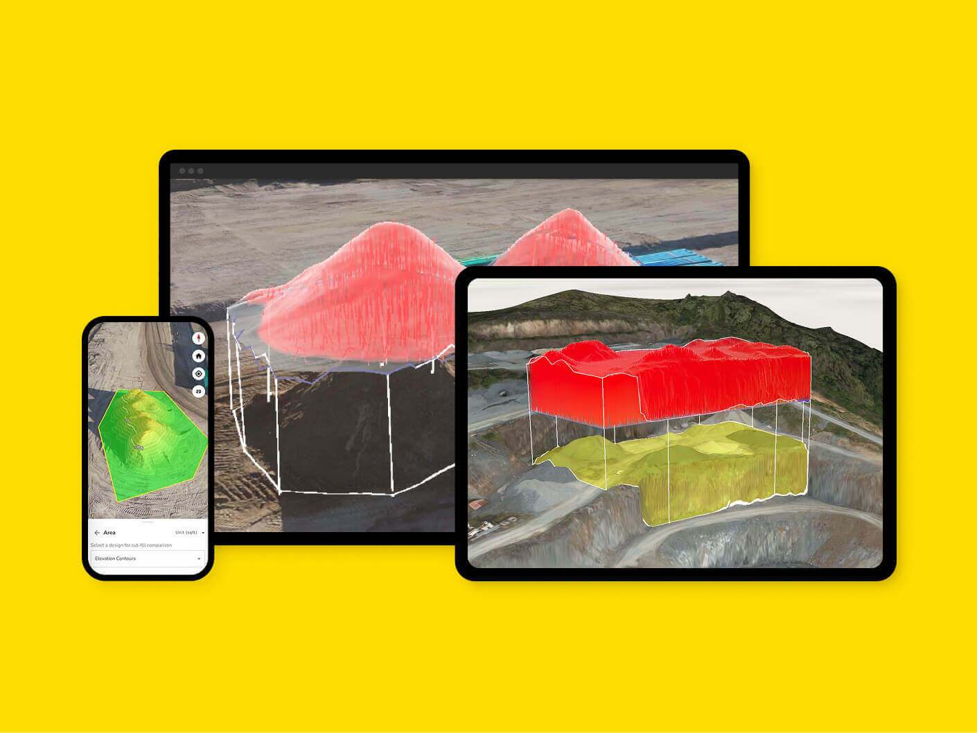
Enhance your site’s performance and streamline your workflows with our advanced drone surveying software, crafted to deliver the top land survey applications for field operations and earthwork projects.

Tap into our comprehensive data analytics tools to monitor your production with precision. Explore what distinguishes our surveying software through its core features, compatibility, and capabilities.

Explore various drone surveying solutions to identify the one that best meets your unique surveying requirements. Gain insights into how Propeller excels in surveying tasks, including its processing abilities and integration with other tools. Reach out to us now for expert advice and tailored recommendations.

Worksites powered by Propeller
Users collaborating on the map
People powered by Propeller
Solutions

Designed to solve everyday worksite challenges

map icon

Map and capture

Turn site data into visual insights. Build accurate maps that unify different data sources and document your work from planning to closeout.

measure icon

Measure

Get precise measurements across your site. From distances and volumes to heights and grades, measure exactly what matters.

track icon

Track

Monitor progress and know your position. See trends, identify issues, and ensure your projects stay on track.

organize icon

Organize

Streamline your workflows. Keep projects tidy, permissions secure, and data easy to access when and where you need it.

plan ahead icon

Plan ahead

Stay ahead of site challenges. Analyze flow, elevation, and runoff to predict outcomes and make smarter decisions.

collaborate icon

Collaborate

Bring your teams together. Share data, reports, and visuals that connect the field to the office, keeping everyone aligned.

Propeller’s end-to-end mapping workflow

A full-integrated solution that helps your people do their best work.

Propeller visualized across 3 platforms

Propeller

Make the map a meeting ground where your project teams can access critical insights on their own

  • Anywhere, any device access
  • Interactive 3D survey experience
  • Simple reporting + analytics templates
  • Surface comparisons + conformance checks
  • Flexible data integrations
  • Centralized media + 360 photos
  • Real-time team collaboration
  • Single-time sign-in
close up of an aeropoint

AeroPoints

Manage AeroPoints usage, monitor hardware health, and run accuracy diagnostics from a personalized dashboard.

  • Accuracy reports + verification
  • Real-time diagnostics
  • Survey management
  • Complete flight history
  • Expansive library of how-to articles
  • On-demand hardware support
Propeller DirtMate being held by a construction worker

DirtMate

Production teams use the DirtMate Dashboard to track daily volumes and access productivity insights.

  • 2D cut-fill heatmaps
  • Survey-grade surfaces
  • Machine haul road metrics + cycle counts
  • Daily machine utilization metrics
  • Automatic data corrections
  • Real-time machine locations
  • Customizable reporting dashboards
DJI M4E flying

Survey processing

Scale up at your own pace, without adding resources, Just drag and drop your dataset into Propeller, and we’ll send back a high-accuracy 3D map in return.

  • One-click drag + drop
  • CRS database with 5,000+ systems
  • Local CRS setup + support
  • Personalized QA criteria
  • Data pre-checks to ensure accuracy
  • Quality reports on blur, contrast, and ISO
  • Seamless AeroPoints integration
  • Custom output configuration