Propeller + Trimble
Integrated Sustainability is using Trimble Stratus, powered by Propeller. Trimble, the global leader in positioning technologies, was an early partner of Propeller. Our teams work closely together to deliver Trimble Stratus survey-grade drone data solutions for the heavy civil industries.
Rethinking the Role of a Geomatics Manager
Geospatial data is the locational lens worksites look through to understand the scope of the job at hand. Without understanding the geographical features and boundaries of a site, there’s no way to effectively plan and execute work. This is what makes geomatics managers like Kris Kwiatkowski an indispensable part of any earthworks operation.
Today, Kris runs the drone program for Integrated Sustainability, a sustainable infrastructure development firm that conquers water, waste, and energy challenges with innovative turnkey solutions, among other fringe tasks.
Although the majority of his day is spent collecting and analyzing progress data, it’s not unusual for him to traverse into business development and sales enablement territory—anything to keep current projects moving forward and more customers funneling in.
When he stepped into his current role, there were some obvious bottlenecks he wanted to overcome:
- Kris was spending hours in various softwares trying to make sense of field data, manually building comparative surfaces to verify quantities.
- Drone surveys were limited to photo-based, single snapshots that lacked context.
- Processing drone data consumed the same amount of time as traditional surveying and kept him and his computer tied up.
With Integrated Sustainability looking to scale, Kris needed to make a change—a change that would reduce his time in the field and give him the support he needs to work on more projects simultaneously.
How do you free up a geomatics engineer’s time? You put technology in place that removes them as the single access point for information. Anytime a construction manager or sales team can independently pull the site data they need, a geomatics engineer puts an hour or two back in their day.
The Two-Phase Propeller Plan: Drone Surveys to Total Worksite Management
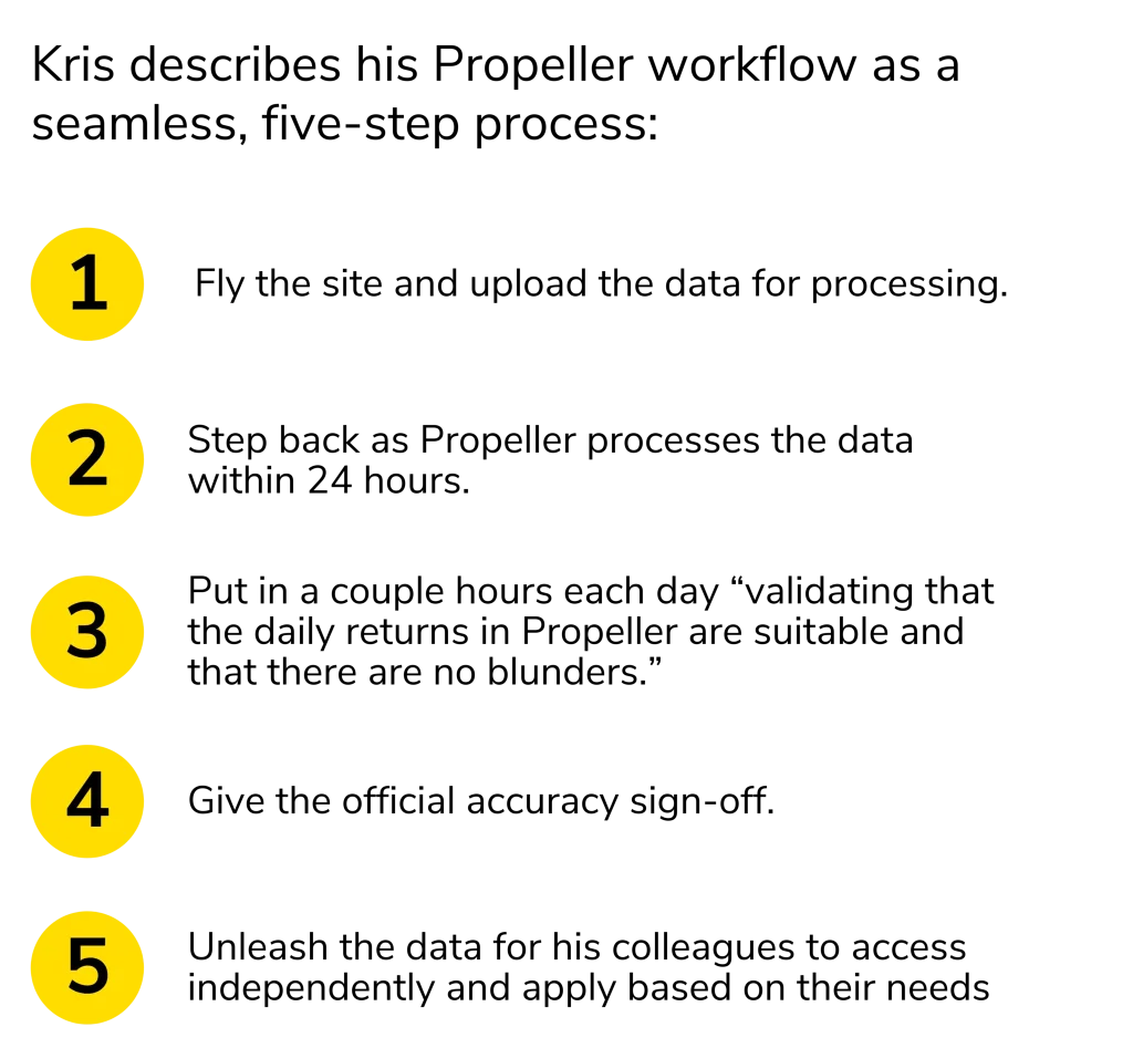
Kris had been working with drones since 2011 and had his eye on Propeller for a while. With Propeller PPK, a complete workflow that brings together “smart” ground control (AeroPoints), 24-hour data processing, DJI’s Phantom 4 RTK, and interactive, 3D maps, it seemed like the perfect solution to take those unreferenced, 2D snapshots they depended on to a whole new level.

He plans to roll their new and improved survey workflow in two phases. They’ve made it through phase one and just started digging into phase two. And even though they’ve been a customer for less than a year, Kris has already cut the number of hours he spends retrieving and aggregating information by 80%.
Here’s how Kris describes his two-phase approach to Propeller adoption.
→ Phase One
Phase one is simply to use Propeller as it’s designed to be used. This includes tracking quantities, measuring progress, and applying the data to avoid rework and keep his colleagues in the field informed.
→ Phase Two
In phase two of Kris’s plan, he intends to take Propeller beyond himself by integrating it into every aspect of the project lifecycle as more of a “worksite management” tool than just a drone surveying workflow.
With this approach, Propeller will serve as a common meeting ground for all the different players on site—”from [their] engineering teams to regulatory teams, to environmental teams, to construction teams” and so on. Essentially, Kris is on a mission to build a worksite that’s powered by Propeller.

How Have Things Changed in Phase One?
Being technically minded, Kris describes himself as, “detail-oriented and focused.” Before, he had to piece those small details together to contextualize why certain decisions were made or why a change to design was necessary.
Now, Kris has all the context he needs in front of him in just a few clicks. Thanks to his transition to automated drone surveys, he spends only 10% of each project in the field. When he is in the field, it’s usually for a project kickoff, setting up the drone workflow, or making sure that his on-site team has the information they need to make the project a success.
The rest of the time, he’s in the office, verifying survey data, working alongside engineers to upload the latest design files, and then layering the two to see how the current state measures against design.
Using this workflow, he’s effectively removed himself as the bottleneck for site data and increased the visibility his colleagues have over data relative to their role because:
- He’s replaced manual calculations with accurate, in-platform measurements that eliminate the need to pull data into CAD.
- He’s upgraded their photo-based, single snapshot data to interactive, 3D site maps with 1/10ft accuracy.
- And he’s offloaded data processing to reduce time expenditure of drone surveys down to a matter of hours and remove the processing bottleneck all together.
Like we said, this is only Phase One. Phase Two of Kris’s Propeller adoption plan is all about introducing different dimensions and use cases for drone data and 3D maps .
Executing Phase Two
To fully maximize value, Kris has begun to get his coworkers involved. By introducing different dimensions and use cases for drone data and 3D maps, he’s breaking down the communication and data silos that traditionally exist between field- and office-based teams.
Integrated Sustainability is no longer just using Propeller on the backend with daily drone flights. They’re also using it on the frontend, in the planning stage. When they eventually get to a point where they’re applying drone data to the entire project lifecycle, he says they’lI “always have all the information [they] need on hand.”
For Integrated Sustainability, transitioning Propeller from simply a drone program to an all-encompassing worksite management platform is an iterative process. As of now, Kris has successfully helped the construction manager and director of technical execution—Gary Smolik and Barry Prystawski—work drone data into their management duties.

Kris has pioneered Propeller at Integrated Sustainability, but we think it’s important to show how his hard work has grown (and continues to grow) beyond his role as geomatics manager.
In the next segment of this case study series, we’ll tell Gary’s story—the story of how quick, verifiable quantities are the fuel that keep his crew running full speed ahead (in the right direction). Follow along as we document Integrated Sustainability’s journey to worksite management.


