If you’ve processed drone survey data with a platform like Propeller, you’ve probably been asked “what coordinate system are you using?”
While a simple question, it’s crucial to accurately rendering your 3D survey. Let’s unpack what coordinate reference systems are, how they work, and why they’re important in drone surveying.
What are coordinate reference systems?
Put simply, a coordinate reference system defines the location of a point on a plane or a sphere.
It provides the X, Y, Z, locations for all points in space, and allows you to consistently determine where you are on the earth.
Without a complete definition of that system (all dimensions), you can’t accurately figure out where you are in relation to other locations or measure between them.
Basics of latitude and longitude
You’re likely familiar with the coordinate reference system of latitude and longitude, which is expressed in degrees, minutes, and seconds. Together, latitude and longitude give you your location on the surface of the earth, excluding elevation.
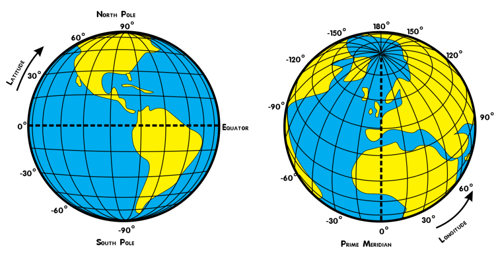
(Lines of latitude—parallels—indicate how far north or south a location is. Picture hula hoops of varying sizes banding the planet parallel to the equator. Lines of longitude—meridians—tell you how far east or west a location is. Since the earth is roughly spherical, lines running from pole to pole are not parallel, but converge as they approach the poles.)
Of course, when you need to work with distances, like road lengths, it’s not useful to tell someone they need to dig 0° 7’ 15″ east (and the math to calculate things in that system are very cumbersome). A worksite needs distances and lengths in feet or meters.
Surveyors translate geographic coordinates into a system using easting, northing, and elevation (called a projected coordinate system), which is much easier to use. To understand how that system works, we first need to explore how we consistently define “zero elevation.”
Defining “zero elevation” and orthometric height
A consistent zero height matters because you need to have a common benchmark to measure from. But how do we ensure everyone is using the same zero?
You probably already know the answer if you’ve ever told someone your city’s elevation. Geodesists, the scientists who worry about such things, decided mean sea level is Earth’s zero elevation. So, for practical purposes, orthometric height is “height above sea level.”
(Many people use height and elevation interchangeably, but height is the distance above a horizontal surface, while elevation is specifically the distance above sea level.)
How ellipsoids and geoids affect that “zero”
Mathematically defining zero elevation would be simple if Earth were perfectly round, but it’s not. The planet’s spinning motion makes it bulge out at the equator and smoosh at the poles. A good approximation of this shape is an ellipsoid.
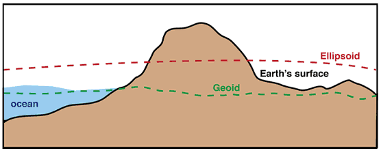
Different ellipsoids fit different parts of the earth better than others. Since the earth is lumpy and squished, some ellipsoids fit a particular lump—say, North America—better than others.
But when defining that all-important “mean sea level” (and thus orthometric height), we need to take into account Earth’s nonuniform interior. It further complicates things because varying densities cause gravity to vary in strength depending on location, which then tugs on the ocean more or less strongly.
This is where the geoid helps—it’s a surface of equal gravity. To picture it, imagine Earth completely covered in water, all the continents sunk. The geoid is the shape made when all the liquid settled naturally with the varying strength of gravity over the planet’s surface. It’s like a roundish potato.
Vertical datums account for local variations
Now that we can find that zero, we also need to find elevation. Vertical datums are built on top of local ellipsoids to take into account local changes in terrain and elevation, and give accurate height values.
While there are vertical datums fitting the whole world, most countries have their own. This is because the continents we live on are not only moving around, but also have mass that gravitationally attracts the ocean, thus changing sea level nearby. Countries use local datums that are “snapped” to their continent or region.
Coordinate reference systems are integral for drone surveying
The science behind coordinate reference systems in complex and fascinating, and there’s much more out there. But now that we’ve covered the essentials—ellipsoids, geoids, vertical datums—let’s go back to that first question of “what coordinate system are you using?”
Propeller needs to know what coordinate reference system you’re using because it provides context to all quantities mapped on your site—road lengths, stockpile volumes, cut/fill quantities, road grades, berm heights, pit depths, and much more. Without known what coordinate reference system you’re in, it’s impossible to produce a useable, readable survey because nothing lines up.
Further, we can’t guarantee the measurements you take on your 3D site survey are absolutely accurate. (If you’re ever surprised by a discrepancy between two datasets, check if they’re using the same coordinate reference system.)

Absolute vs. relative accuracy in drone surveys
A drone survey model has either absolute or relative accuracy. “Absolute” accuracy here means global; it’s how well a point on a map corresponds to a real-world coordinate system, like that used by GPS. Whereas “relative” accuracy only indicates how well that point corresponds to other locations on that same 3D survey.
While many companies say relative accuracy is enough, in reality, it isn’t incredibly useful for worksite surveys. No matter your industry, you’re working with many different coordinate reference systems, not just using one unique map where relative accuracy would serve you well.
The advantage of absolute accuracy in drone surveying
Absolutely accuracy lets you compare two datasets of the same site from different time periods or a specific drone survey against a design surface—both of which you’d want to do when assessing progress and productivity on your worksite.
It also lets you translate from one system to another, like when your drone images are GPS-tagged with lat/long coordinates and you want outputs to reference the state plane coordinate system. (For those sites on a local grid, this will sound familiar.)
It’s important to understand ideas like absolute and relative accuracy and how coordinate systems work, but the good news is that platforms like Propeller handle most of the technical work for you. You just need to help with that all-important step of telling us which system you’re using.


