Over the past several years drones have fundamentally changed the way construction and earthworks companies analyze and manage their worksites by delivering accurate, reliable survey data. Here, we explain the common factors that can affect drone data accuracy and provide some tips to help you get the best results from your aerial surveys.
1. Image overlap
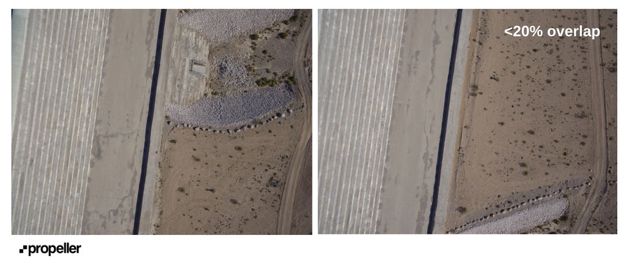
When flying a drone over your site, always ensure the images you’re capturing overlap by 70 percent.
The basic principle of photogrammetry requires matching the features among photos in order to form a single, contiguous model. In order to do this, captured images need to overlap substantially. The most common issue making aerial photos unusable is a lack of overlap. However, it’s often the easiest to correct. Generally, a minimum of 70% overlap is required between photos to ensure proper alignment for processing. This means that for each photo taken during a drone survey, only one third of the features it contains should be new.
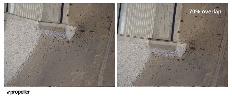
Your flight control app allows you to select the amount of overlap in your flights. Make sure to select the appropriate camera model, and, if possible, use a high point on your jobsite for take off. Taking off from a low point may cause you to fly too low to the ground over higher areas, resulting in poor image overlap.
2. Resolution / GSD and accuracy
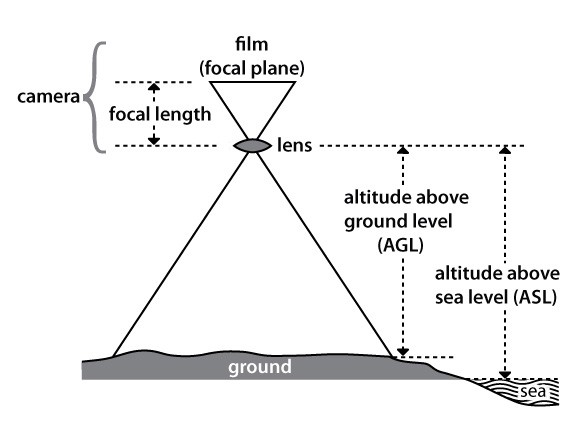
Another factor to consider when surveying your worksite is the ground sample distance (GSD) of the photos in your survey. The GSD is the real-world size of a pixel within your images, and for most drone flights it’s between 1 and 10 cm. A low GSD (1cm) is very high resolution imagery, and a high GSD means lower resolution.
GSD is determined by:
- The resolution of your camera sensor — a 12 megapixel camera will have a higher GSD than a 22 megapixel camera
- The altitude of your flight — flying higher means a higher GSD
- The focal length or field of view of your camera — a wider angle camera means a higher GSD
In general, the final accuracy for a model in X and Y is 1–2 times the GSD in the horizontal, and 1–3 times in the vertical; however the average error tends to be closer to 1x GSD for all axes.
3. Flight speed
The accuracy of your data can be significantly affected by how fast you’re flying. Generally, you’ll need to fly slower for better accuracy, and use the highest possible shutter speed and ISO settings on your camera.
A typical fixed-wing drone flies at a minimum speed of 11 meters per second (m/s), and typically a fast shutter speed is 1/1000 of a second. This means that in the time the shutter is open, your drone will have moved 11/1000 of a meter — which is 1.1 cm.
This movement can cause a very subtle warp/distortion or a blur in the image, an effect called ‘rolling shutter,’ resulting in reduced accuracy. Processing tools can correct this error.
To avoid blurry images and rolling shutter, use a shutter speed where your drone moves less than 1/3 of your GSD between image captures. If your camera can only capture at a shutter speed 1/1000 and your drone can’t fly slower than 11 m/s, you should plan your flight to capture just over 3.3 cm GSD.
4. Absolute and internal accuracy
Regarding survey accuracy, knowing your point of reference is important. Points within a survey model may be accurate relative to other points within that same model, known as internal accuracy. Alternatively, the same survey may be accurate with relation to its true position on the earth, otherwise known as absolute accuracy.
Internal accuracy is important when you’re measuring a volume or a length within a specific survey map.
Absolute accuracy is critical for comparisons of multiple data sets from different time periods.
Here’s how you can achieve optimal internal accuracy:
- Use an integrated system that directly connects the camera with the GPS. If you only use exchangeable image file format (EXIF) tags post-survey, the timestamp is stored in whole seconds, meaning the actual GPS coordinates can be off by several meters.
- Make sure that your camera is properly calibrated and synced with your GPS clock to log positional information at the same time each photo is taken. Clock errors are the most common source of internally inaccurate data and are usually one of the first issues encountered by new drone pilots.
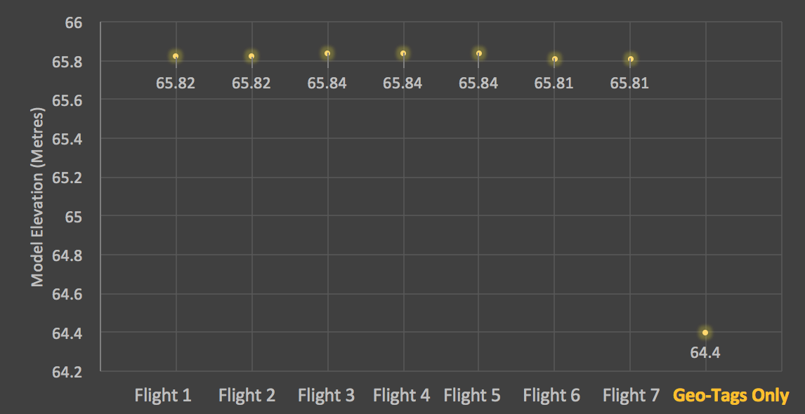
Example: A clock error 1/10 of a second on a fixed wing drone traveling at 10 m/s introduces an error of one meter to the captured data. - Capture a large volume of data. If you only take a few dozen photos of a small area, the GPS inconsistencies can lead to large errors. More GPS location data helps minimize the errors.
Unfortunately, even a perfectly-calibrated camera and standard GPS unit can still produce errors of several meters or more, depending on flight conditions.
A proven method of improving GPS accuracy is to fly with a real time kinematic (RTK) module on your drone to provide additional corrections. With RTK, you don’t need to rely on ground control and you’ll have the ability to produce consistent results accurate within several centimeters.
However, RTK requires a strong, uninterrupted cellular connection between a base station and the module in order to stream its corrections. When surveying particularly large sites or a site with poor GPS reception, a drop in this connection makes your corrections unusable until the signal is recovered.
To achieve consistent internal and absolute accuracy, ground control points are your best option.
5. Ground control points
While pursuing accurate data, good ground control is key. Technologies such as on board RTK do provide improved accuracy in the air, but this does not automatically translate to the same level of accuracy on the ground. Terrain models corrected with onboard RTK data are more susceptible to turbulence, vibration and camera calibration errors than models generated using ground control points (GCPs).
Combined errors of 10 degrees or more in a drone’s measured pitch or roll can introduce tens of centimeters of error in the final model, if no GCPs are in place. With this in mind, achieving centimeter level accuracy in surveys with on board RTK is significantly more difficult without employing ground control points.
Research has shown the efficacy of ground control points in surveying and photogrammetry. Absolute accuracy with GCPs can be trimmed from meters to centimeters making them the gold standard for survey-grade data.
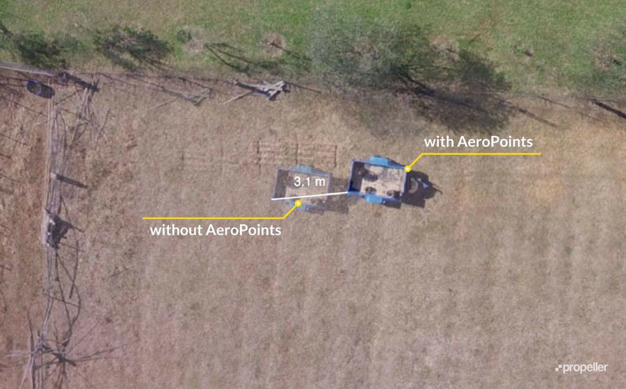
Traditionally setting up ground control points was slow, costly and complicated. However this practice has changed with the availability of Propeller’s AeroPoints. These smart ground control points with inbuilt GPS are easy-to-use and capable of capturing incredibly accurate positional data.
If you are considering using ground control for your drone surveying, visit our AeroPoints page to find out more.
Accuracy in, accuracy out
Almost every aspect of a drone survey job — from the drone and camera used to the flight conditions and ground control implemented can affect the accuracy of your final data.
When submitting your data for processing it’s important to understand that a 3D model is no more or less accurate than the data used to generate it. Consider accuracy requirements when setting up capture tools for your next drone flight, and you’ll produce high quality sources for your maps and models. These tips should assist you in avoiding common problems and improve your data accuracy.