
For anyone who’s worked with GIS software or a drone survey visualization platform, you’ve almost certainly used DXF files.
Developed by AutoCAD to be interoperable with non-CAD software packages, DXF files are versatile in the types of data it can contain. The wide range of capabilities makes DXFs incredibly useful in a number of industry applications, but none more so than earthwork.
The information contained in DXF files make it easier to plan, analyze, and streamline earthwork operations in construction and a number of other industries.
Here are the top five ways you can use DXF files alongside drone surveys to improve your worksites.
1. Use DXF files to measure earthwork volumes
If your DXF file contains a 3DFACE entity type, you can measure volumes of features in that DXF file against your 3D survey surface. This workflow cuts the time it takes to make accurate volume measurements by as much as 70% over a traditional CAD workflow, and simplifies the process to three steps.
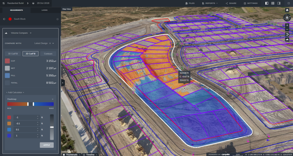
In a CAD package, you’d typically upload a survey and create a surface from that. Then, you’d have to create another surface from a second survey, and do a surface-to-surface volume between those two after creating your boundary. And when you’d want to update it, you’d need to do part of the process over again.
But using intuitive drone data analysis software, that boundary is already saved. Depending on the size of your file, you’re saving on average ten minutes to an hour every day–time savings that pay out over your workweek.

2. Visualize your current terrain against a design surface with a DXF file
Using a DXF, you can upload one or multiple designs and see what your site looks like today against how it will look when the work is done. This lets you see how you’re progressing overall, as well as what the final site will look at end of life.
For example, if you’re on an aggregates site, you can view how the quarry looks today, and then compare it to one-year, five-year, and end-of-life plans, overlaid in a 3D format.
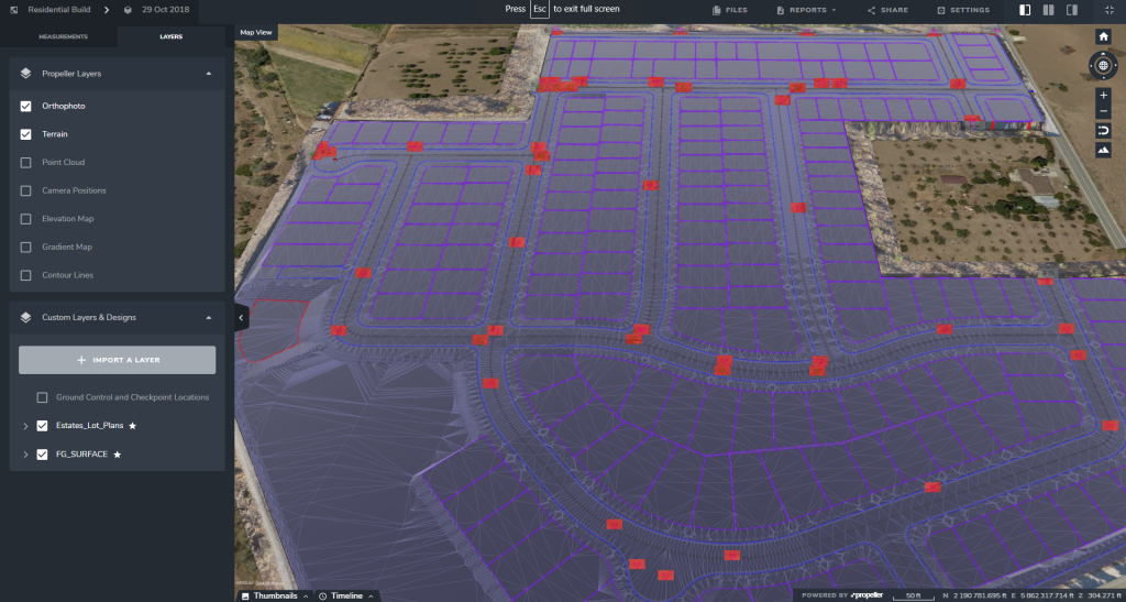
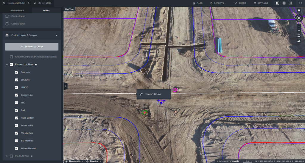
3. Easy layers viewing
With a good drone data visualization platform, the DXFs you upload can be used just like in your CAD package: it’s one file that includes all your layers. You can upload it in one go, and then turn different layers on and off as needed.
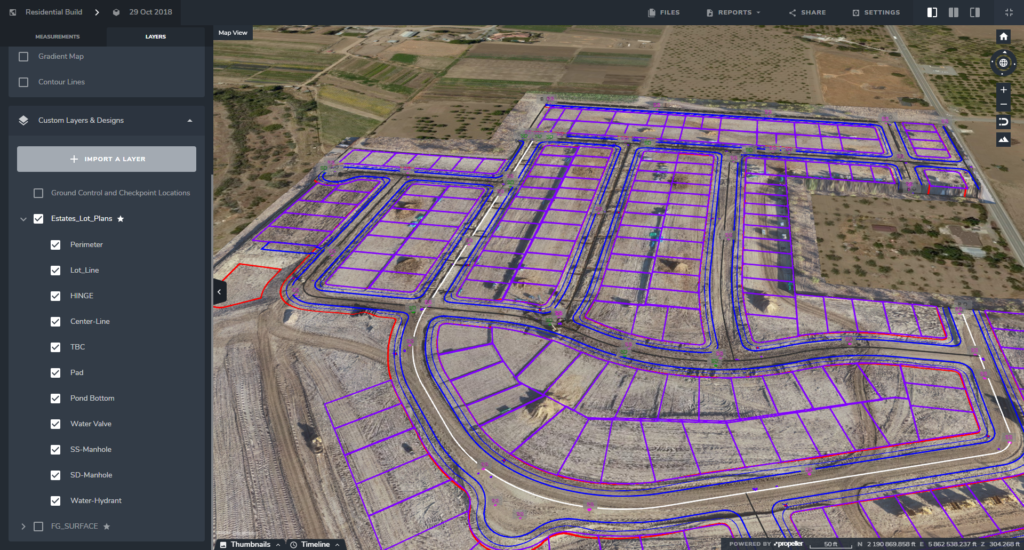
For example, if you’re on a construction subdivision, you can import your DXF with all the utility lines, property lines, etc. If you need to see where your electrical and plumbing is sitting on the terrain, turning off everything but that utilities layer takes just a few clicks.
Knowing exactly where utility and property lines are at all times is hugely important to avoiding costly errors that could turn into even more costly disputes.
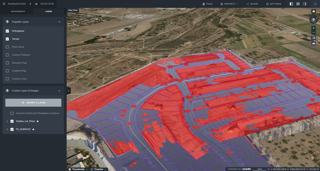
4. Simply visualize surface features
Seeing what’s on your site in 3D—from real-world features to abstract values—is a powerful visual. Using the information stored in DXF form, you can display info simply and straightforwardly.
Below, a DXF surface is shown in 3D. Areas in red are the current drone survey that’s above the design, which means this shows all the cut needed for this site to reach design.
Another underestimated ability of DXFs is their power to show how abstract values look in relation to the site itself. With DXFs, you can add in these values and view them spatially over an up-to-date model of your site.
If you’re on a landfill, and you’ve flown a drone to record the air quality, also known as a “gas sniffer,” Propeller can bring those collected points of the air quality which have X, Y, Z values into your 3D survey and overlay it on the terrain.
And, because it’s a DXF, if you’ve got the gas sample figure loaded on there, we can actually see it overlaid on the site.
The same goes for soil compaction measurements. Instead of a spreadsheet with coordinates and rates, you can load the DXF with that information into your drone survey analysis software and see those rates in 3D space.
5. Convert anything
Lastly, a simple but powerful ability is to convert data from DXF files into measurements.
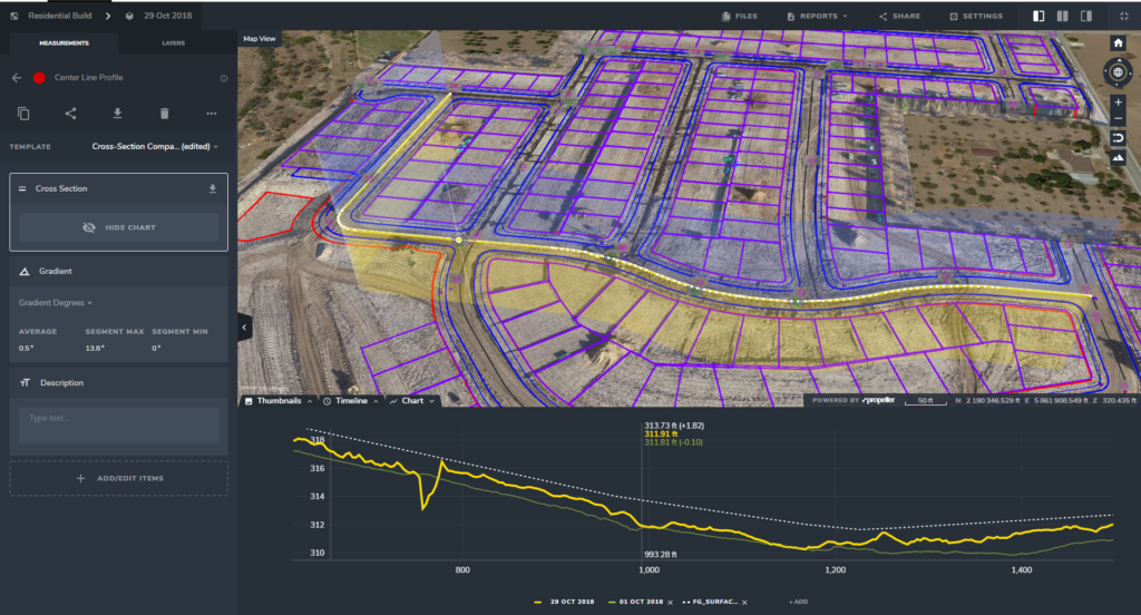
If, for example, you have a DXF with a line, you can load it into Propeller and use that same line in 3D to measure your site. This goes for many important benchmarks, like road alignments with cross sections, in DXF files. With one click you can convert the DXF cross-section line into a measurement and compare the surveyed surface to the design file.


