If you’re familiar with drone surveying, you may have come across the term ground sample distance, also called ground sampling distance (GSD).
Your GSD directly impacts the accuracy of your surveys, so it’s essential to understand how it works. This article explains what ground sample distance is, how to calculate it, and how it relates to your drone data.
What is ground sample distance?
Ground sample distance is the distance between center points of each sample taken of the ground. Since we’re talking about digital photos in drone surveying, each “sample” is a pixel.
In simpler terms, the GSD represents the size of one pixel on the ground.
Below, you can see an AeroPoint captured 30m (~100ft) above the ground with a Phantom 4 RTK drone. If we zoom all the way in, we can see the individual pixels that make up the image. In this example, one pixel in the image represents a 0.82cm (~0.32in) square in the real world. This number is the GSD.
What is the difference between ground sample distance and spatial resolution?
As we discussed, GSD refers to the dimensions of a single pixel in an image, as measured on the ground. GSD calculation considers the drone’s sensor properties and focal length (distance between sensor array and the camera lens), as well as the distance between the sensor and the ground when the photo is taken. This is normally represented by the altitude of the drone. Spatial resolution refers to the pixel size within an image with respect to some real world object or terrain feature in focus.
When working with flat ground, the distance between sensor and ground is similar across the entire photo, meaning spatial resolution and GSD are relatively equal. However, since spatial resolution describes the dimensions of a pixel relative to any object in focus, the spatial resolution of objects across an image with variable surface relief can deviate from the calculated GSD in such a way that objects closer to the sensor have a higher resolution, and those farther away have less.
Why is it important to calculate ground sample distance?
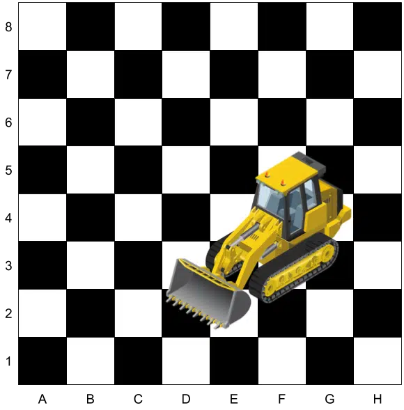
Digital images are grids of colored squares (pixels), much like chess boards. Let’s say we have a (very) big chessboard, and someone has parked a front-end loader on it.
We need to tell the supervisor where it is, so they can send someone to move the loader—but we can only use the squares on the board for measurement.
What are our accuracy requirements? Well, we need accurate enough data to find the loader.
Since the loader is much bigger than the squares we’re using to locate it, we can tell the operator to head to square F3, where they will easily find the loader to move it.
But what if they need to know how wide the bucket on the loader is, so they can send the correct operator to move it? Again, we can only use the squares on the board for measurement.
What are our accuracy requirements in the revised scenario? This time, we need accurate enough data to measure the bucket and identify the loader.
The bucket is more than one square wide, but less than two—a huge range as far as loader buckets go, so we can’t measure the bucket accurately enough with our squares. We would need much smaller squares to determine the bucket’s width accurately enough to correctly identify the loader.
How can I calculate ground sample distance?
If you’re wondering how to calculate ground sample distance, we have good news and even better news.
- The good news is that the calculation isn’t particularly complicated (we’ll explain below).
- The even better news is that we’ve built the Propeller GSD Calculator to do it for you!
Calculating ground sample distance with the Propeller GSD Calculator
The simplest way to calculate GSD is to use the Propeller GSD Calculator. Here’s how it works:
- Select a drone from the list
- Enter flight altitude
- Select correct units (metric or imperial)
That’s all there is to it! You can also enter a custom drone configuration, but all of the recommended drones are in the calculator.
Propeller GSD calculator example
For example, let’s imagine that we want to determine the GSD of a Phantom 4 Pro flying 80 meters above the ground. We’d simply plug in these values to the calculator:
- Select the Phantom 4 Pro
- Enter 80 as the flight altitude
- Set units to meters
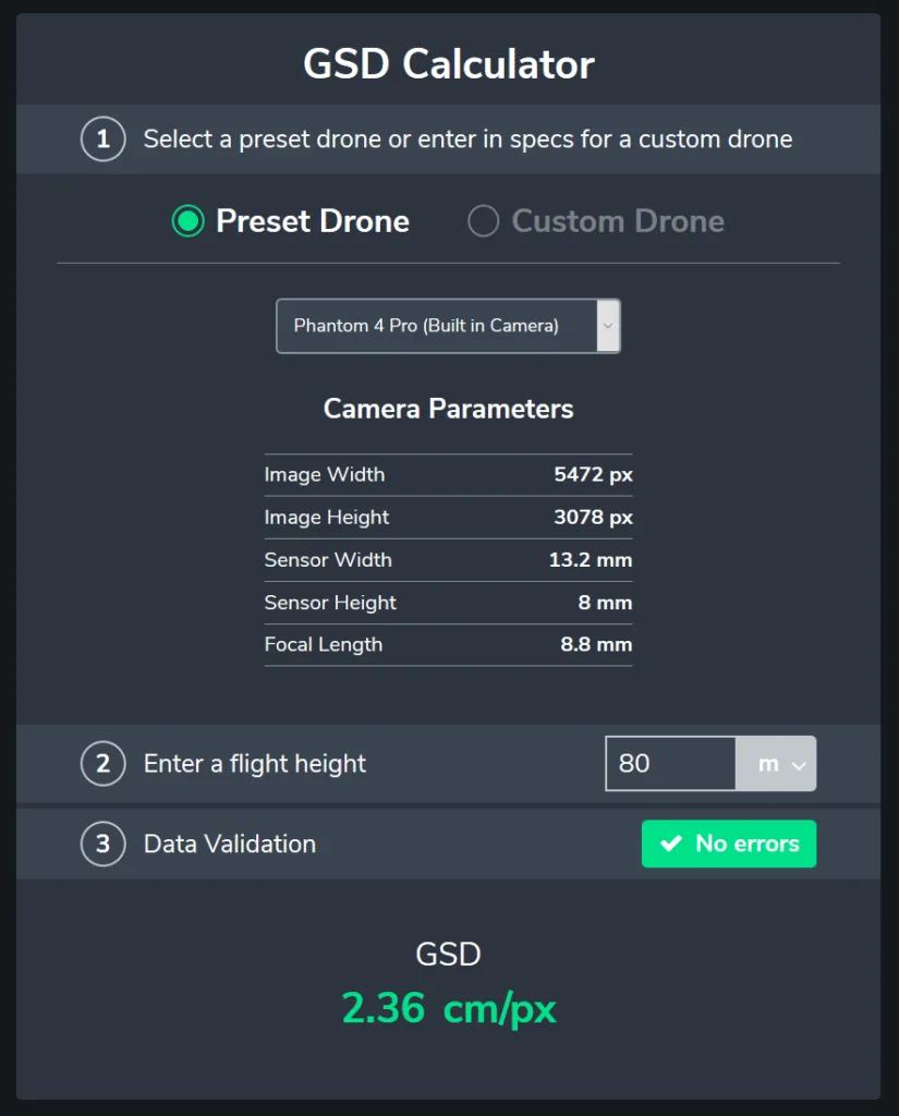
GSD = 2.36cm/px.
How do I calculate ground sample distance manually?
As promised, we’ll also share how to manually calculate GSD. Below is a diagram showing all of the relevant factors for calculating GSD. These figures should be publicly available for any drone that you might fly.
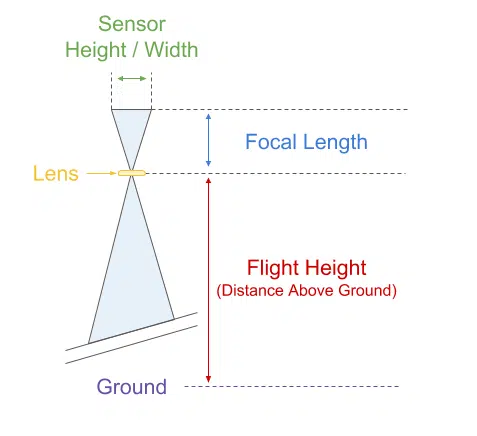
When you project one pixel onto the ground, it’s not perfectly square, so when you calculate the GSD, you’ll use the greatest (worst) value of the results from two different calculations:


- Image Width: 5472px
- Image Height: 3078px
- Sensor Width: 13.2mm
- Sensor Height: 8mm
- Focal Length: 8.8mm
So, substituting the values (in centimeters) into the formulas, we get this:


You’ll use the greatest value (or the worst case scenario), so in this case: GSD = 2.36cm/px.
How ground sample distance improves drone surveying accuracy
GSD helps in drone flight planning by directing surveyors on how high the drone should fly to capture photos and what camera settings to use, including sensor width, focal length, and image resolution. Elevation plays a key role in the accuracy of GSD. For example, flying a drone over a large pit or tall stockpile affects the GSD and potentially the accuracy of the survey because of the different terrain heights.
With lower GSD, anyone using the survey map can measure distances of objects on the ground to a highly accurate degree. The lower the GSD, the better your accuracy when measuring surfaces of different elevations, keeping the difference between the real volume and the measured volume of a stockpile to a minimum.
Once a GSD is calculated, it’s used to guide the drone in flight. GSD determines the following aspects of flight planning:
- The correct altitude for the flight
- The survey image resolution
- The camera parameters (sensor width, focal length, resolution)


