
Mining contractors plan and adapt to changing conditions on site, relying on up-to-date models to make decisions. High-quality terrain models in the mining environment are common and techniques like aerial surveys, laser-scanning, and hand topos have been well established for years. However, these traditional methods often are not easy or cheap to create and are typically only accessible to engineering, geology, and survey teams. That is, until drone surveying with photogrammetry became a common way to collect inexpensive, highly accurate data.
The arrival of drone surveys with photogrammetry marked a big step forward for the mining industry, but it also introduced new challenges.
With the advances in data collection and processing, the size and quantity of survey data being shared has ballooned in recent years. Even with powerful computers, processing can be slow and survey models can become too large to load. The solution? Cloud-based drone data storage, processing, and analytics.
Cloud-based drone survey, analytics, and 3D mapping solutions, like Propeller, enable mining contractors to survey their sites with greater accuracy and precision, without creating excessive and unnecessary surveys for unchanged areas.
By leveraging composite surveys, for example, mining contractors are better equipped to collect, share, and use survey data, without wasting time, resources, or energy in the process.
Let’s take a closer look at some innovative techniques for collecting and sharing data in the modern mine.
Composite surveys for mine sites
Although most of a mine site’s footprint may not change from day-to-day, there may be times when a full mine site model is needed. As a result, the whole site may be unnecessarily surveyed. The time and money spent to collect high-quality drone survey data over unchanged areas represents resources that could be allocated for something else.
Composite surveys offer a new, more-efficient way of merging site surveys. In Propeller, surveys can be merged in real time, regardless of size, revealing a surface of the most up-to-date model in all areas.
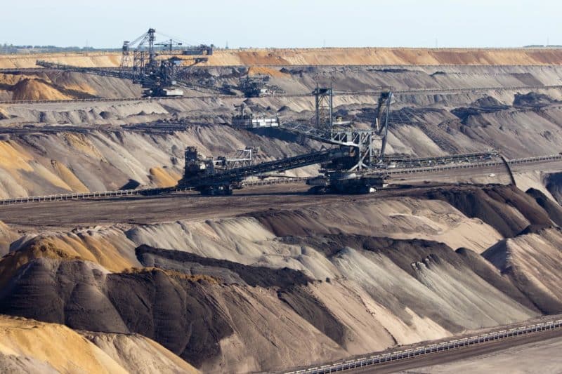
Two common scenarios encountered in the mining environment that can be addressed with composite surveys include large base site surveys and updates to the bottom of a pit.

Large mine site base survey
Large base aerial surveys for a mine site are often conducted on an annual basis, underpinning all other models. Most of the site does not change during the year, so there is no practical reason to re-survey these unchanged areas (e.g. reclaimed pits, undeveloped areas).
The base survey may be conducted using lidar, photogrammetry from a traditional aircraft, or via a fixed-wing drone.
A composite survey in Propeller introduces merging functionality to everyone, even those with minimal technical experience.
For example, let’s say that a 3,000 acre mine site needs to be surveyed for an annual report. After the survey, a tailings engineer flies a survey of a dam to monitor erosion. In the past, a team member with technical knowledge would need to manually merge the surfaces using specialized software on a powerful computer. The merged survey would then be re-uploaded to a shared platform.
With Propeller’s composite survey functionality, however, non-technical staff can merge the surveys together on their own in seconds. They do not need to ask for help or employ any special resources. Also, they do not need to reshare any of the data. The model remains in the common environment (Propeller) where everyone has access.
Updates to the bottom of a pit
The pit is often the area of most activity and the most challenging area to fly. Each day, conditions change as blasting and mucking occur. Once an overview survey of the pit has been completed, smaller sections can be flown to update the larger survey.
Survey staff can conduct daily surveys of the bottom of the pit and merge them with a larger survey of the pit for context. Anyone with access to Propeller can create an updated model of the pit by merging the new base model with the old surrounding model. There is no need to ask anyone for help or ask the survey team to spend all day creating a new model when flying the bottom of the pit will suffice.
Sharing large datasets between teams
Drone surveying creates highly accurate survey data. Unfortunately, that accuracy can translate to large datasets that can be difficult to use, store, and share across teams.
Frequent, high-accuracy data collection is only useful if it can be easily distributed to the people that need it. The average user does not have the technology required to open such large files.
There are two main difficulties: the capacity to share large amounts of geospatial data and the ability to use large geospatial data for analysis.
Sharing large geospatial datasets
Shared drives, cloud storage, portable USB drives, and email are not the best choice for sharing large, high-accuracy survey datasets. Not only are these traditional storage options slow, insecure, or simply inadequate, they also are prone to version control issues, meaning a team member could inadvertently be working with out-of-date information.
Frequently updated surveys almost immediately create a versioning problem. Even with a structured data warehouse, it can be difficult to know whether someone is accessing the most recent and accurate data.
A cloud solution, like Propeller, can store the files in a secure, third-party location. This ensures that the files are always accessible and available for analysis. Associated files are bundled together and kept in a visible format to eliminate versioning issues. This means that a user can see what they want before they download and that all data becomes truly self-serve.
Using large geospatial data
Manipulating large datasets in a 3D space can be quite challenging, especially for the large datasets used on mine sites. This creates a natural barrier between the technical services and everyone else. Powerful computers must be paired with expensive, complicated software to analyse the models produced.
The Propeller platform allows anyone with a reasonable internet connection to have the full functionality that a technical services worker with a powerful computer could once access. For example, they can look at a 500 gigabyte image overlaid on a terrain model, spin it in 3D space, and then analyze material movement. Cloud survey software is very useful to the technical teams, but it also opens access and analysis tools for everyone else on and off site.
Next-gen mine sites survey with photogrammetry
There’s a time and a place for every surveying technique. Drone surveying with photogrammetry, however, is the next generation of surveying for mining sites. Not only does it offer greater functionality and usability across mining teams, it enables all stakeholders to seamlessly and consistently access accurate survey data—no technical expertise required.


