
If you manage a landfill, you may have been wondering how you can use drones to help improve the performance of your site by:
- Tracking and improving your compaction rates
- Producing accurate compliance reports
- Performing volume and airspace calculations
- Exporting the data for better informed planning and design work
We’ve built tools that let you see through time, generate reports with three clicks and calculate compaction rates on the go. This article will showcase these tools and walk through some of the ways that they can help you improve your site’s performance—all without walking over a single piece of trash!
Managing environmental areas
Monitoring environmental areas is vital for any landfill. At any moment, you may need to prove that a “no-go zone” (which may be there for a protected species) has never been affected by your operation, or you may need to know and be able to communicate where contaminated waste has been stored. Here are a couple of tools we’ve built to make these tasks easy for you.
Site-level measurements
If you have an area that requires regular reporting, just mark it out once and promote it to site level. Now every time you capture your landfill, you can include updates on that area in your reports.
Timeline
It is fairly common for environmental protection agencies to check in on landfills to ensure that protected areas have not been tampered with. Using the Timeline tool, you can quickly and easily perform visual checks through time to prove that there has been no foul play.
With our tools these kinds of questions are easy to answer, without Propeller answering them can be a long and expensive process.
Keeping your landfill site close to the design
Cross Sections
Landfill operators need to get as many tons of waste under the top of waste (TOW) design as possible, therefore operators often overfill their cells, knowing it will eventually settle back under the TOW design.
That said, if you overfill too much or overestimate your subsidence rate, you risk significant repercussions from your environmental protection agency and/or local council, such as having to dig the waste back down to spec.
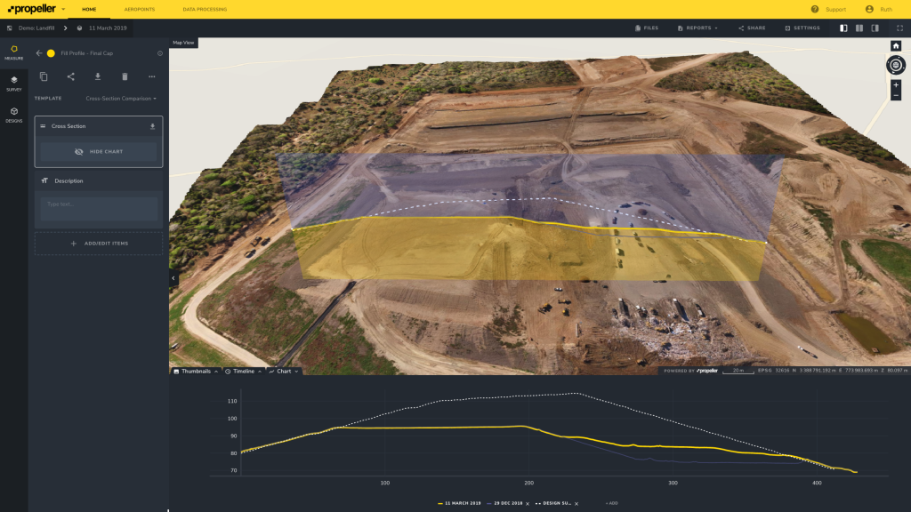
There are a few ways to measure your overfill in Propeller, the first and most familiar format would be using cross sections, as seen below.

The orange line represents the current actual and the dotted white line is the TOW design. You can also see that the cell has been overfilled by around 2.5ft where the cursor is hovering. Depending on the subsidence rate at this landfill, this may be an issue that needs addressing.
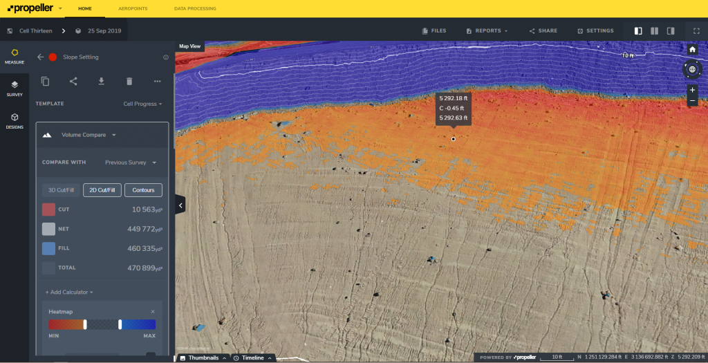
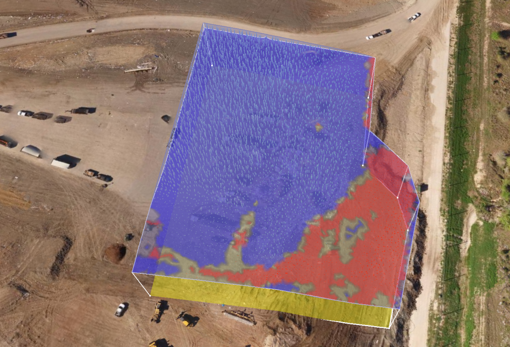
Overfill / Airspace Maps
To describe an entire landfill, you would usually need to walk multiple lines across the trash, use those points to interpolate an approximate elevation model and then compare that model against the TOW design.
Using Propeller, you can generate more intuitive cut/fill maps that represent overfill and airspace, using higher resolution data with just a few clicks (see example below).
Rather than a color scale on the ground, the differences are projected in 3D above the ground.
Improving landfill cell management
Compaction Rate
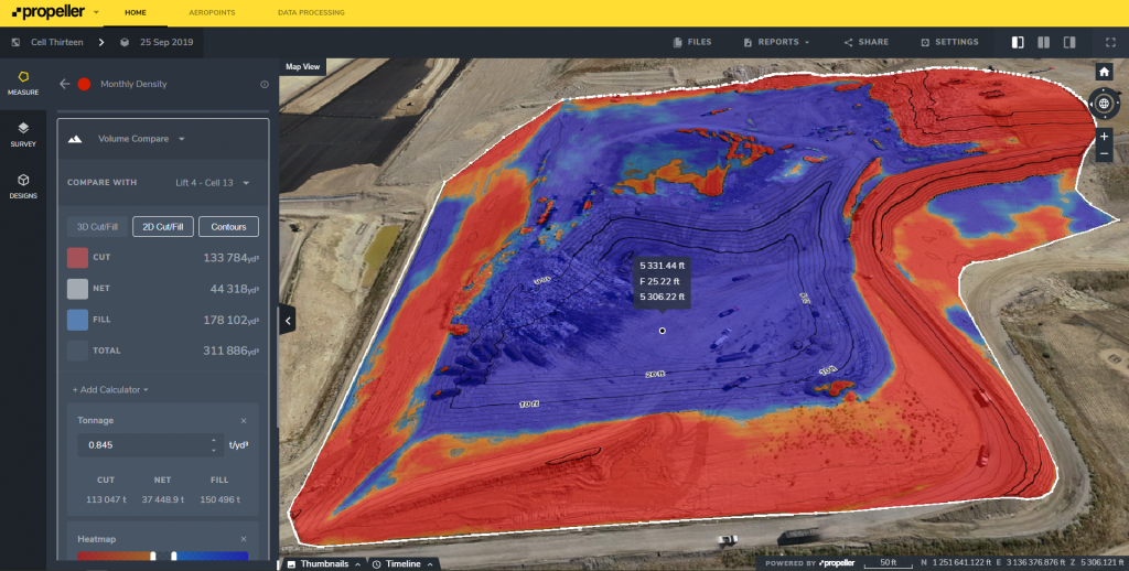
Landfills get paid per ton of waste and they have a set amount of airspace that they can fill. Therefore, how much waste you can get into that airspace defines the performance of any landfill—this is the compaction rate.
If you have a weighbridge, a drone, and access to Propeller, you can easily measure your compaction rate every time you fly.
- Draw or import your cell boundaries.
- Select Volume Compare and set an appropriate date to compare to.
- Turn on the density calculator and enter your weighbridge data.
You can promote your cell boundary to site level so that you can produce printable volumetric reports with three clicks every time you fly, which is important to do on a quarterly/monthly basis for contractual talks and operator reviews.
That said, at this frequency, by the time you get the information it’s generally too late to be able to react to changes. It’s like driving a car that only tells you what speed you were going hours after you were driving.
Since flying a drone is so easy, fast, and inexpensive, you could capture your landfill weekly or even daily to arm yourself with accurate and up to date information to actively manage your landfill.
Training Feasibility—Worked Example
Let’s say you’re considering launching a program to improve and maintain operator skills by training them every six months.
For anyone with operational experience, this is a no brainer—investing in good operators makes all the difference in the world, however, proving this has been difficult or impossible until now.
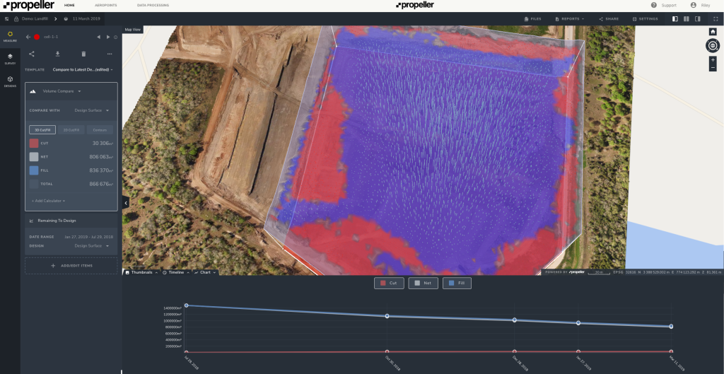
The first thing we need to know is how much airspace we have left in the cell. If you’ve imported your design surface, all you need to do is add another volume comparator to the cell and set it to the design surface. This will calculate the remaining airspace in that cell.
By entering in the current and the improved compaction rates, we can quantify the significance of improvements over the lifespan of the cell.
Here is an example that uses hypothetical figures for the same cell (figures are rounded here):
- Expected compaction improvement: 0.02T/yd3
- In the last 3.2 months, 45,000T of waste has gone into 65,500yd3 of airspace
—> Current compaction rate = 0.69T/yd3
—> Fill rate = 460T/day - 373,500yd3 of airspace left and $/T = $70
—> At current compaction rate, airspace left = 256,600T
—> At improved compaction rate, airspace left = 264,000T
—> Therefore, extra waste that we expect to fit into the same airspace = 7,500T
—> Extra revenue for cell $523,000 - At improved compaction rate, 264,000T remaining at 460T/day
—> Time left to fill cell 1.6yrs - Training $1,000 per operator, two operators, every six months
—> Cost per year $4,000
—> Total cost of training in cell lifetime (four cycles) = $16,000 - Return On Investment (ROI) = 32x
$16,000 in training → $523,000 in revenue = 32x ROI
Clearly, investing in operator training, even with just a 0.02T/yd3 is well worth it. In fact, you could spend ten times this amount and it would still be a great investment!
Using Propeller, investments like this are easy to justify.
Tracking Progress
Now that you’ve started regularly training your operators, you can accurately measure improvements on a daily/weekly basis to track performance and make adjustments where necessary to ensure that the project delivers the value that was promised.
This kind of closed loop project cycle is the height of operational excellence today, and with drones and Propeller it is easily achievable. All without becoming an expert in photogrammetry, nor walking over a single piece of trash.
Ensure the accuracy of your drone data
All of the workflows outlined in this article require sufficiently accurate data.
To ensure that your data is reliably accurate, the most important factor is appropriate ground control. Landfills present a unique challenge for all permanent ground control solutions—the ground won’t stay still!
Since the ground is constantly subsiding (in the order of 1m/yr [1yd/yr]), any surveyed in ground control points rapidly become unusable. Therefore you have two options:
- Survey in ground control points every time you capture the landfill.
- Use AeroPoints (smart ground control points).
You may or may not decide to go with AeroPoints, but it cannot be overstated how important having current and accurate ground control is. Without it you have no way of being certain that your data is accurate and so you cannot rely on the results, especially if you’re comparing data from different points in time (vital for compaction rates).
Note that this still applies for RTK or PPK drones. Their quoted accuracy may meet your requirements, however there are many potential sources of error, so you still need to truth a few points (at least) to confirm that the actual accuracy is sufficient.
To find out more about how you can use drone data on your landfill site get in contact with us.


