
We’re on a mission to make life easier on the worksite, and, to truly do that, surveyors, engineers, managers, and all other users needed a way to take their maps into the field. When our customers told us they wanted PDF map export capabilities, we listened.
Today, we’re excited to announce all Propeller users can now quickly and easily export their site maps to a PDF. Using PDF site maps, you can arm your entire team—whether they’re knee-deep in excavation or analyzing drone data behind a screen—with the information they need for orienting, planning, and checking progress.

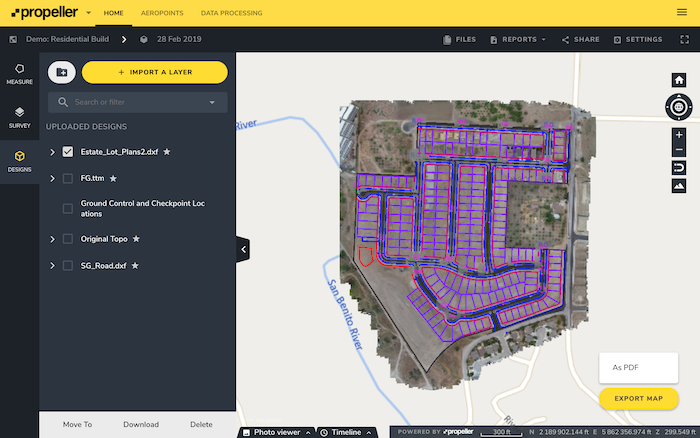
In just a few clicks, you can create high-resolution maps of your site and customize the map with design overlays and linework. From there, you export, print, and share with whoever needs it.
It’s challenging to keep track of what’s happening on the job site—there’s lots of different people working niche jobs on just one particular section of the worksite. Some are operating in the field, others in the office.
So, the question is, how do you prevent physical separation from turning into information silos? And how do you keep your entire crew informed regardless of their location?
Our solution? Printable and up-to-date site maps that everyone can reference to monitor progress and stay connected to the big picture.
Custom maps your entire team can create without special training
Even though the Propeller Platform’s is a quick learn, it still requires a moderate level of technical know-how. The new PDF map export feature makes it possible for anyone with a Propeller login to tailor professionally formatted maps to their specific needs in a matter of minutes.
Before, surveyors and engineers were overburdened with one-off requests for information, since they were gatekeepers for all things aerial data. PDF exports completely remove that time-suck by making it possible for everyone (no matter what level of platform proficiency) to create maps for themselves.
No need to call on a specialist or take someone away from another task. PDF map exports are the self-service approach to the Propeller Platform. This way no one misses out on all that actionable data the platform has to offer.
Quick exports keep owners and executives happy
We get it. Sometimes your client or owner asks for an update and you don’t have the bandwidth to stitch all your site plans together to give them a full site view.
At the same time, you want to maintain transparency and keep everyone happy. Sometimes you have the full site view, but the file’s too large to send as an email attachment. PDF map exports only take a few minutes and they’re easy to pass on to whoever needs an update.
If you’re in the middle of comparing progress against design by layering your DXF over your most recent flyover data, you can export that too. Just select the layers you want to include with your orthomap before you click Export.

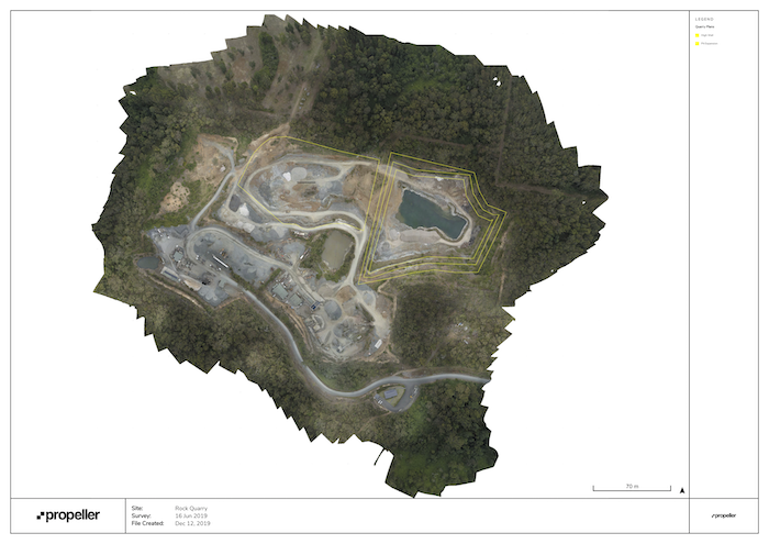
No more messing around in CAD for hours; no more miscommunication. You can show your owners and executives exactly what’s happened since your last flyover—the lay down areas for subcontractors, overlays that indicate where the contractual work will take place, and linework mapping out utility lines.
More map users = more connected worksite
Use your site map as your homebase. Since it’s now relatively easy for anyone to climb aboard and give PDF map exports a go, invite your entire team to your Propeller portal.
Each and every one of your employees can benefit from up-to-date site data; it’s what keeps everyone connected to the big project picture
Even if they’re not exporting, the printed version can certainly clear up any uncertainties about directions, progress, or planning upcoming work. The more people that understand what’s happening outside of their neck of the worksite and how their part contributes to the health of the whole, the more communicative and connected your worksite becomes.
Anyone directing site-based crews will no longer need to spend time using multiple, complex software packages to create and print maps. They can replace this process with a few clicks in Propeller.
Once you’ve tried out the PDF site map, make sure to give us your feedback. Your feedback is how we make tools to make life on the worksite easier for you!
Need some help getting started? Here’s a quick guide to creating your own printable PDF orthomap using Propeller.


