Getting a drone surveying program started is the hardest part of moving into a drone-based surveying workflow.
Drones have moved firmly from toy to tool in the last couple of years, but the work of figuring out exactly which one you need and which data visualization and processing software you need can be tricky. Often, this can cause delays getting things off the ground.
Choosing the wrong drone data visualization software provider means risking a false start, making it harder to win the minds (and budgets) required to make drone data a success for your business.
Get it right the first time. Ask the right questions of your software providers.
1. What drone should I use and why?
Drones generally come in two types: fixed-wing and multicopters. Fixed-wing drones can fly for longer, but require large takeoff and landing zones. Multicopters have shorter flight times but can takeoff and land almost anywhere.
We recommend DJI drones. They’re reliable, competitively priced, and have high-quality cameras. DJI multicopters can fly for more than 30 minutes and their gimballed camera means they can fly fast, covering more ground per minute than a fixed-wing drone.

We’ve found the reduced fly-time traditionally associated with multicopters is best addressed by simple battery swapping.
When choosing a drone, consider the following features and formats:
Ownership: Leasing vs. buying
Some companies charge customers annual fees to lease a drone from them. With arrangements like these, you run the risk of paying more than you would for off-the-shelf hardware and of delays when drone repairs/maintenance are required. You’ll be obliged to work through issues with your provider, as opposed to going direct to the retailer or manufacturer for a fast refund or replacement.
If you want to do a trial of drone surveying technology, leasing can be a good short-term option.
No matter what you’re considering, be aware of hardware and accessories mark-ups, and think about the lifetime cost of your chosen solution.
Drone grade: Specialty vs. consumer
Off-the-shelf drones can be a great choice. They’re affordable, robust, and simple to use. In contrast, we’ve found that more expensive enterprise-grade drones are often needlessly complex, while doing the same things a consumer drone can do.
That said, with the recent release of DJI’s Phantom 4 RTK drone, high-accuracy drone survey data is more affordable than ever to capture.
2. How do you help me get survey data? Where do you fit into the surveying workflow?
Companies vary. Some provide solutions for part of the surveying process or all of it. Make sure to clarify where the business in question fits in.
We find that there are generally three stages of surveying: collection, processing, and visualization.
Some companies might only sell products that help you capture survey data, but then you have to find self-processing solutions to get that data into a readable, useful format for your site.
Other companies require you to bring the data to them. Then they work as processing engines for that survey data, offering data exports to your favorite modeling software.
There are also some who cover two of these stages or provide end-to-end solutions. Ensure their solution is fully explained, and ask how it fits in with other products they sell.
For example, we at Propeller provide tools for all three stages, but you can buy whichever tools you need. Propeller PPK is a complete hardware solution that uses the Phantom 4 RTK and one AeroPoint to get centimeter-level accuracy across an entire site.
Or you could also bring your data to us for processing and visualization in the Propeller Platform. You can also import preprocessed data directly into the Platform to help with site analysis and measurements.
3. How do you ensure accuracy on your maps and models?
When it comes to surveying of any kind, accuracy is key. Make sure your chosen vendor understands why ground control is so important.
Surveyors overwhelmingly agree that even when using drones with onboard RTK/PPK you still need a method to “ground-truth” the data you collect, and a means to confirm data accuracy and integrity.
Does the vendor provide quality assurance reports? Does it give you enough information to check the numbers yourself?
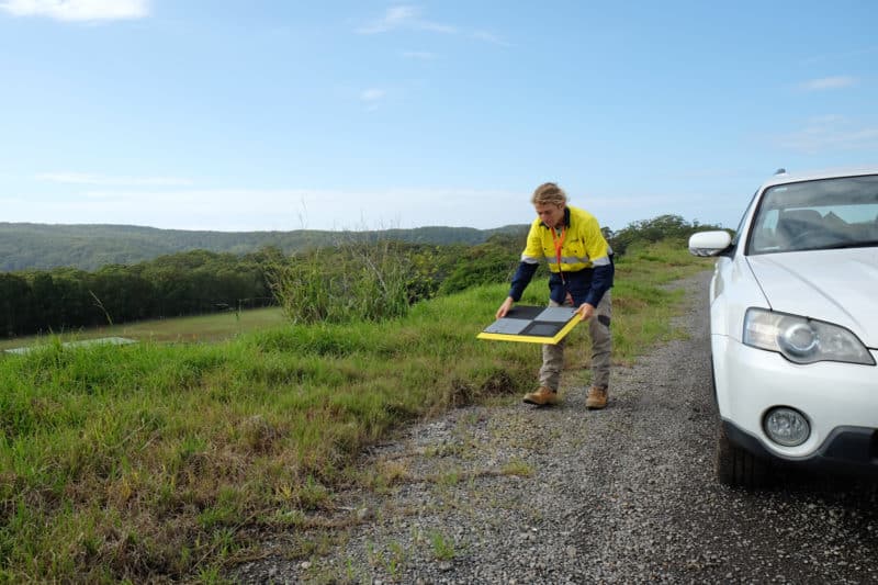
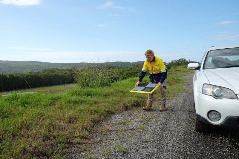
You can establish ground control in a number of ways, but AeroPoints are one of the easiest ground control points to use. They work with any drone, in any location, without extensive operator training. (And with Propeller PPK, you only need to use one for 1/10ft accuracy.)
4. How do I get an accurate survey from my drone data?
The term “drone surveying” covers just one part of the workflow that gets you a 3D site survey, but is often conflated with others.
Essentially, there are three processes that happen to produce that final accurate survey of your site, which we covered above in Question 2. The first is collection. This is when the drone is actually flying, when you’ve deployed ground control points, and the drone is taking pictures.
The second is processing. This happens after you upload your drone imagery and ground control data to a processing platform like Propeller. Once that data is received, that software uses photogrammetry to stitch aerial photos together into a 3D model of your site.
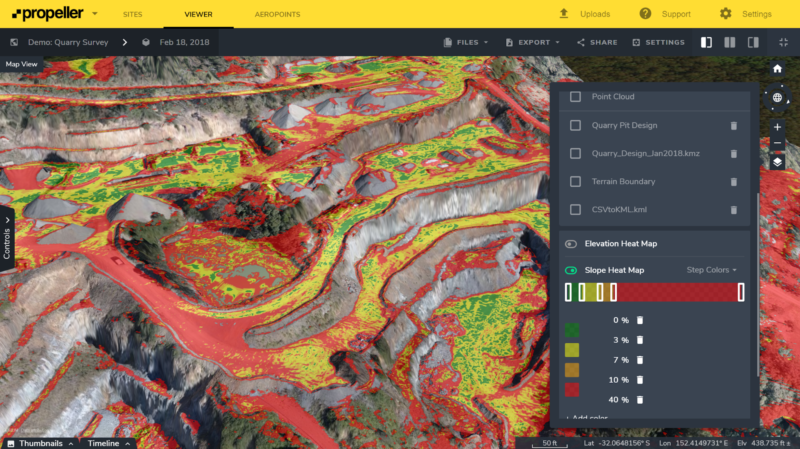
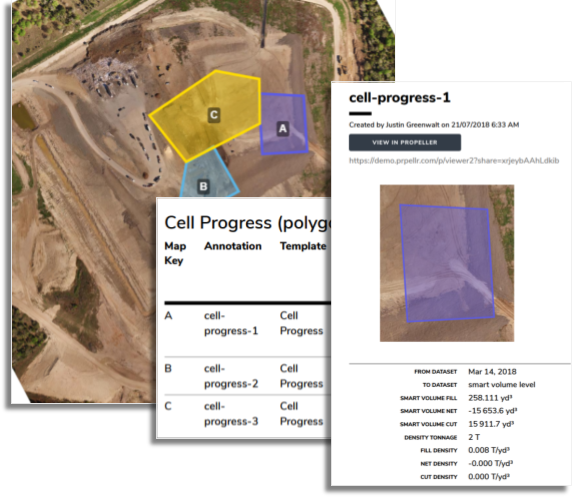
The third part is where analysis comes in. This is the point where you come back in to use the visualized data to make measurements and report on your site.
Some vendors do one or more of these stages, so make sure you know which they cover. Ask about collection and processing. What kind of data can you submit? What can they process and how long does it take?
Many companies also tout their automatic processing, but it’s worth asking how their “automatic” processing actually works. If there’s a problem with your dataset, how will this be identified and communicated to you? What are the qualifications of the person you’ll be speaking to in this scenario? At what hours of the day will they be available to help you?
At the last stage, when you’ve got your survey and you want to use it, ask about their support options. Do they have 24/7 support? How can you reach out to ask questions?
For example, Propeller’s in-house data success team are true experts in surveying and photogrammetry. Offering 24/7 support, they personally check each and every job.
5. How does your solution integrate with my existing workflows?
As an established business, you likely already have software systems and workflows that you don’t want to see disrupted or replaced.
Ask how a solution will complement your existing workflows and make your day-to-day easier. Data needs to be able to be imported, exported, transfigured, and manipulated to suit your unique business objectives and the ways you already do business.
See how easy it is to export files. Can you get your data in PDF, CSV, DXF, or others?
If you use third-party software, make sure integration is easy and seamless. You don’t want to waste working hours with busy work just to move your data into something like Trimble Business Center, Carlson, Global Mapper, Maptek I-Sight, Vulcan, Surpac, Civil 3D, AutoCAD, and more.
6. Do you support my local site calibrations?
For both accuracy and practicality, many worksites operate according to their own unique “local grid” (as opposed to, say, the standard global latitude/longitude system WGS84).
If this is you, it’s important to be aware that not all software providers support local site calibrations.
If your site works on a local grid and your drone surveying platform doesn’t support local grid calibrations, the data you receive won’t immediately be usable for day-to-day operations. It won’t match up with your plans (or be comparable to past or future surveys). To fix this, you’ll need one of your people to transform/convert each piece of drone data into local grid coordinates.
7. How easy is it to verify and defend my results?
Drone survey data is often used to make high-stakes decisions or to resolve disputes. Ask how easy it is to validate results after processing and how confidently you can stand behind the outputs.
Can you review checkpoints, accuracy reports, and residuals without specialist tools? Is there a clear audit trail that shows how the data was processed from raw imagery through to final outputs?
The easier it is to verify and explain your results, the easier it is to build trust with internal teams, clients, and external stakeholders.
8. What happens when something goes wrong?
No matter how experienced your team is, there will be days when conditions are less than ideal or a dataset doesn’t process as expected.
Ask what happens in these situations. How will issues be flagged? Will you be notified proactively, or do you need to discover problems yourself?
It’s also worth understanding whether you’ll be supported by automated messages or real experts who can diagnose issues, explain what happened, and help you fix it quickly.
9. How scalable is this solution as my program grows?
Many drone programs start small, but successful ones tend to expand fast. Ask whether the platform can scale with your needs.
Can it handle larger sites, more frequent flights, and multiple teams working at once? Does pricing scale predictably as usage increases?
A solution that works for one pilot and one site should still work when you’re flying weekly across multiple projects.
10. How future-proof is the platform?
Drone hardware, positioning systems, and surveying standards continue to evolve. Ask how the platform keeps pace.
Does the provider regularly update its software? Will new drones, sensors, and positioning technologies be supported without forcing you to change your workflow?
Choosing a platform that evolves with the industry helps protect your investment and ensures your drone surveying program continues to deliver value over time.


