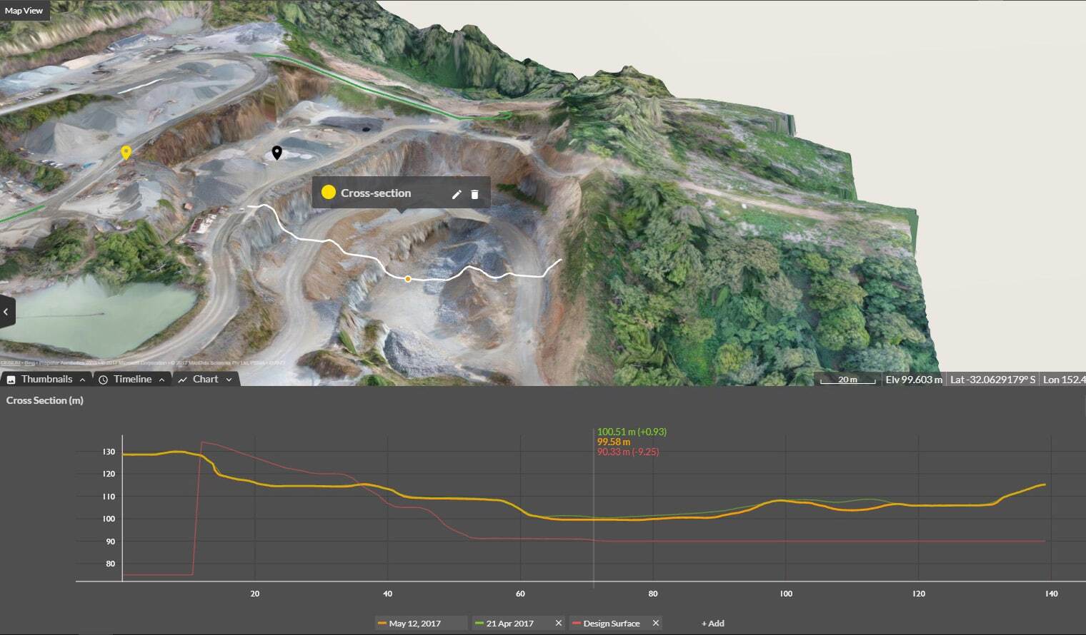
Cross Section Survey in a Matter of Minutes Using Drone Data
With the power of drone-captured data and the Propeller Platform, surveying cross sections becomes as…
Know your drainage patterns before storms hit. Visualize water flow, model runoff, and prove stormwater compliance — all from your drone survey data.
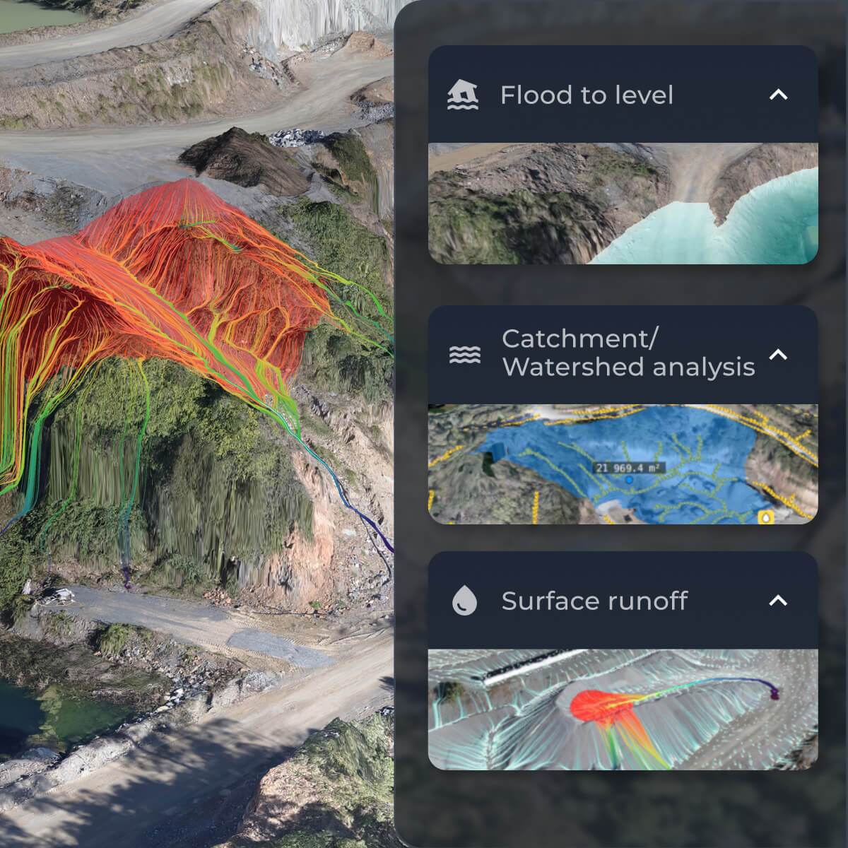
Visualize water flow patterns, drainage patterns, and flood levels so you can take proactive action. Identify construction site water management issues before they cause erosion or equipment damage and prove environmental compliance with stormwater compliance and watershed management regulations.
Poor drainage patterns and unexpected flooding can bring work to a halt. Prepare, prevent, and protect your worksite with Propeller’s flood risk analysis tools.
Check your designs and as-builts to ensure water drains correctly, avoiding pooling, erosion prevention issues, and liability disputes.
Identify flood-prone areas before storms hit so you can optimize drainage patterns, relocate equipment, and protect crews from water-related risks.
Document compliance with stormwater compliance plans, watershed management regulations, and tailings dam safety requirements—without extra work.


“We started using Propeller to capture weekly project photos for the client and track waste material quantities as we reprofiled the landfill. By modeling the existing site, we could compare it to the final design, track cut/fill balance, and monitor progress throughout the project.”
– Jonathan Wills, Director at Wills Bros

Seamlessly integrate Propeller data, including digital elevation models, with your favorite tools. Automate reporting, streamline operations, and maximize efficiency.
Propeller’s surface runoff tool lets you model how water will move across your site during rainfall events, spills, or major storms. Using your drone survey data as a base, the platform identifies where water will pool, flow, or create erosion risk — so you can adjust drainage plans before problems develop on the ground.
Propeller includes several hydrology tools purpose-built for earthworks: surface runoff simulation, watershed analysis, a direct rainfall simulator, and a flood-to-level tool that shows which areas will be impacted at different water depths. Together these help teams plan drainage networks, document compliance, and adjust grading strategies based on real site data.
Propeller’s hydrology tools help you document and demonstrate stormwater compliance by simulating runoff behavior and showing how your site drains relative to your approved plans. Watershed analysis lets you identify catchment areas and outflow points, while the rainfall simulator lets you evaluate drainage performance under different storm intensities — giving you defensible data for regulators.
Yes — drone surveys capture the high-accuracy terrain data that powers Propeller’s hydrology analysis. By processing drone imagery into a 3D surface model, Propeller can identify low points, slope issues, and areas prone to pooling or erosion that would be difficult to spot with a ground-level inspection. Surveys can be repeated over time to track how drainage conditions change as the site evolves.
Runoff simulation models the path water takes as it flows across your site — useful for identifying erosion risk and planning drainage routes. Flood-to-level analysis shows which areas would be submerged at a set water depth, helping teams identify high-risk zones for equipment storage or active work areas. Propeller supports both, letting you assess drainage and inundation risk in the same platform.