Streamline projects with road construction surveying and digital stationing
Track progress, verify work, and understand exactly where your project stands with connected drone mapping, GNSS, and digital stationing data. Propeller gives road, rail, and aviation teams a shared view of alignments, quantities, and site conditions across every phase of construction.”
One map, the whole corridor
From existing conditions to final submittal, keep your project connected across every phase so your team can prove progress, protect margins, and build to spec with confidence.
Pre-construction
Know what’s there before you build
Capture accurate existing ground and right-of-way conditions, so your survey and estimates start from real data.
Grading
Balance cut and fill as you go
Track grading progress and cut-fill balance across the project so you can move material efficiently and stay on grade.
QA / acceptance
Confirm every layer to spec
Verify subgrade and surface layer conformance against design so acceptance is fast and backed by high-precision data.

Documentation
Deliver a clean record
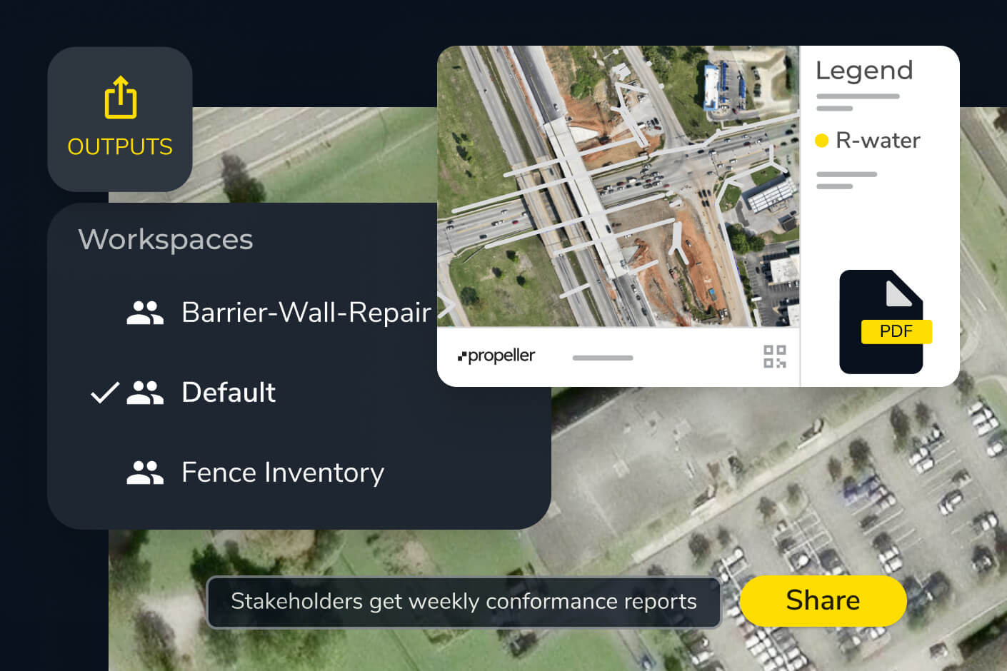
Compile DOT submittals and record drawings from as-built data your team can trust and hand off with confidence.
Unify your site data in one platform
Capture, store, and manage all transportation survey data in Propeller, whether it comes from drones, GNSS rovers, total stations, LiDAR, photogrammetry, or machine data. Visualize 3D models, measure earthwork quantities, compare as-designed vs as-built conditions, and track progress for linear projects in one system of record.
This unified approach supports road construction surveying workflows across highways, rail corridors, and airfields while maintaining a clear audit trail for public agencies.
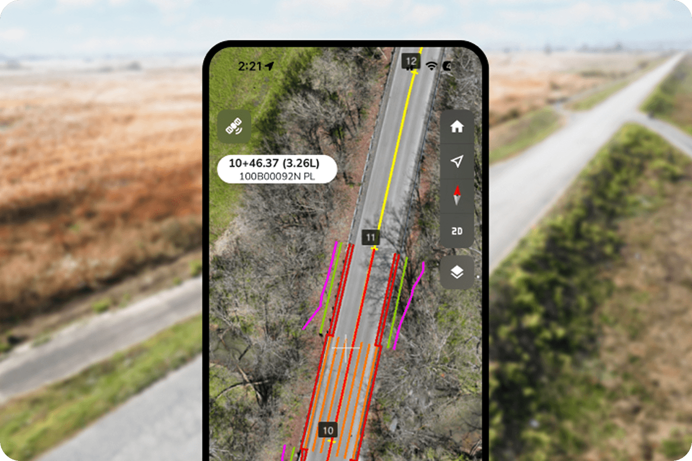
How digital stationing modernizes traditional highway surveys
Propeller replaces manual stationing methods with digital stationing tools that connect design alignments directly to real-time GPS data. Upload LandXML files from Civil 3D or OpenRoads and reference stationing or chainage instantly on a 3D map or mobile device.
Field and office teams can locate centerlines, offsets, cross sections, and right-of-way boundaries without repeated staking or rework. Alignment updates stay consistent across the entire corridor, even on complex linear projects.
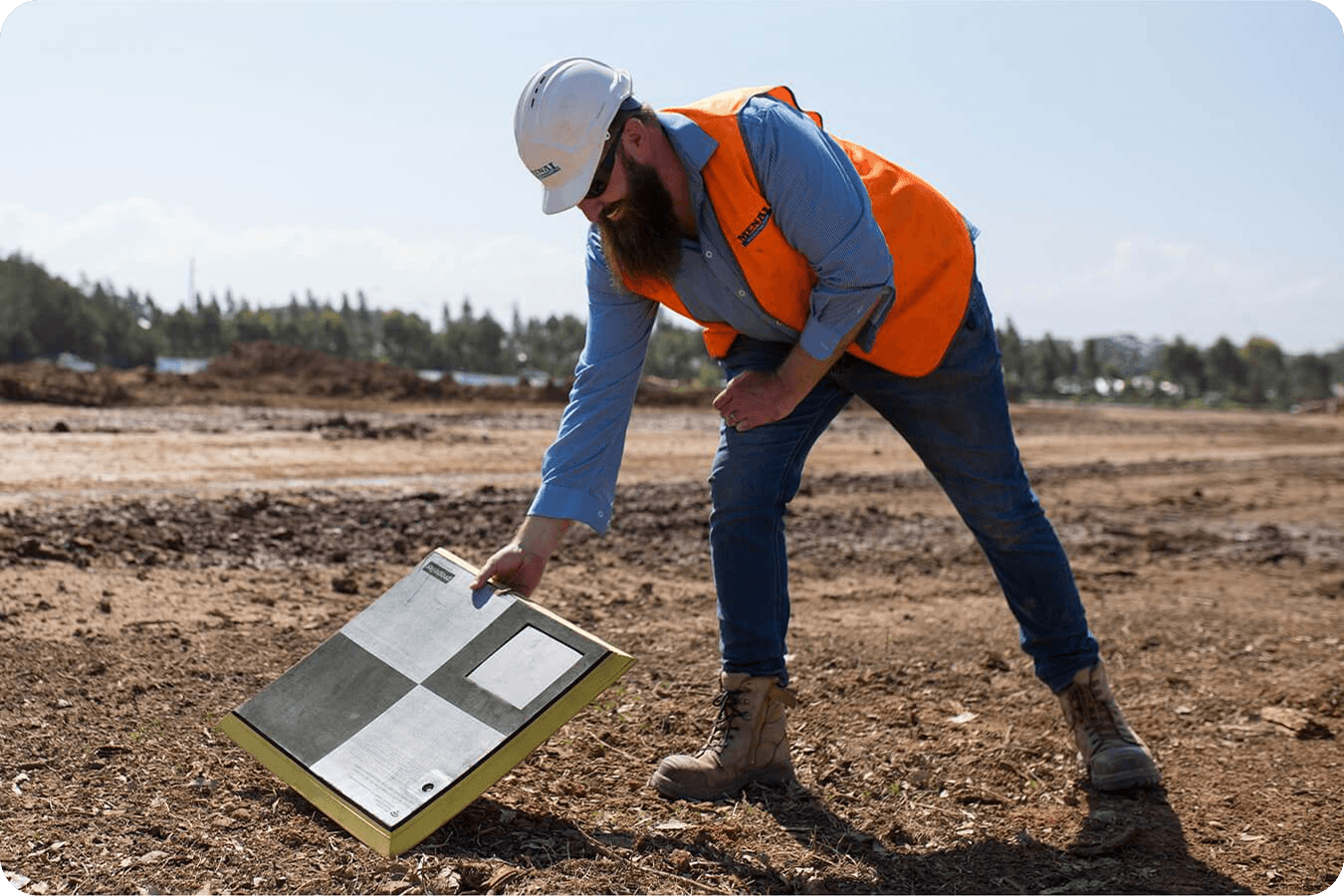
Ensuring accuracy on large-scale linear projects with AeroPoints
AeroPoints are Propeller’s smart ground control points designed to scale road construction surveying across long corridors. Easy to deploy and highly portable, AeroPoints deliver consistent centimeter-level accuracy for corridor mapping, alignments, and stationing tasks.
By combining AeroPoints with PPK drone workflows, DOTs and contractors can verify pay quantities, validate as-builts, and confidently measure earthwork quantities over miles of roadway.
Drone mapping for road construction

Planning and design
Transportation projects depend on accurate, data-driven planning and clear communication across design teams. Propeller centralizes survey data and GCPs with digital stationing software to help teams align on design intent from the start.

Construction
Keep linear projects on track with real-time progress tracking, automated reporting, and design conformance checks that flag deviations before they become costly rework.

Maintenance
Maintain transportation assets with confidence using reliable historical survey data, giving DOT teams a complete digital record to guide inspections and long-term upkeep.
Plan every mile with accurate, connected site data
Bring survey, GIS, and design data into one shared map before construction begins. Analyze alignments, measure constraints, and assess hydrology early so you can reduce downstream risk and make informed decisions from day one.
Know the ground before construction begins
- Unify site data from any source into one platform
- Analyze existing conditions along the alignment before construction starts
- Measure cross sections and right-of-way constraints early
- Use hydrology analysis to identify potential drainage and flooding issues
- Uploading data
- SWPPP tools
- Workspaces
- Markup
Track progress and verify work across active linear projects
- Use digital stationing tools to reference alignments in the field
- Compare as-designed vs as-built surfaces to confirm construction accuracy
- Measure earthwork quantities and validate pay quantities
- Collaborate in real time using Propeller Mobile to capture field conditions
- Area progress
- Compare to design
- Cut-fill
- Mobile app
Maintain transportation assets with reliable historical data
- Track surface change over time along roads and corridors
- Maintain auditable records for regulatory compliance
- Use slope and hydrology analysis to manage stormwater and HAZMAT risk
- Identify and measure areas needing repair using up-to-date surveys
- Hydrology tools
- Media
- Flythrough
- Markup
Build and maintain transportation infrastructure with confidence
From planning through maintenance, Propeller gives DOTs and contractors a modern approach to road construction surveying, combining drone mapping, alignments, and digital stationing tools in one secure system.
Frequently asked questions
Stationing is a linear referencing system used to describe positions along an alignment, such as a road or rail corridor. It is often expressed as station values, chainage, or milepoint. Digital stationing connects these references directly to design alignments and survey data.
Propeller uses uploaded alignment files and digital stationing tools to ensure all teams reference the same centerline and station equations, keeping stationing consistent from planning through maintenance.
Yes. With Propeller Mobile, field teams can view alignments, stationing, and offsets directly on their device using real-time GPS.
Propeller compares drone and ground survey data against design surfaces to measure earthwork quantities and confirm as-built conditions with high accuracy.
Propeller supports DOT workflows with AeroPoints and PPK processing for centimeter-level accuracy. Teams can upload LandXML alignments to verify as-builts, track mass haul, and maintain compliant, auditable records.
Yes. Design files such as LandXML can be uploaded and overlaid on drone-captured 3D maps to track progress relative to design stationing.
Digital stationing uses cloud software and GPS data to reference locations against a design alignment, replacing manual staking with faster and safer workflows.
Drones reduce the need for surveyors to work in live traffic or unstable areas by capturing high-resolution data remotely, improving safety across transportation corridors.
Yes. Propeller data can be exported in formats compatible with Autodesk Civil 3D, Trimble Business Center, and other industry-standard CAD and BIM tools.
High-precision accuracy on road construction projects requires three connected tools: PPK-enabled drones for high-resolution capture, ground control points like AeroPoints for centimeter-level positioning, and digital stationing software that connects drone-captured surfaces to design alignments. Together, these tools replace manual chainage surveys and deliver auditable accuracy across corridors.