
Cut and fill extraction, sometimes called “excavation and embankment,” means moving earth from one location to another to reach a particular surface or volume.
Construction teams use cut and fill maps generated from topographical surveys, often performed by drones, to see where they need to add or remove material. Having accurate cut and fill maps helps construction teams plan earthwork projects, track material inventories, and monitor progress.
Cut and fill calculations are critical for understanding how much material needs to be excavated or added to reach a desired grade. Accurate calculations help construction teams plan earthworks, control costs, and avoid delays caused by incorrect volume estimates.
Ever wondered about the most common use case for drone surveying on construction sites? Well, wonder no more—it’s cut and fill volume calculations. Cut or fill calculations matter at every project stage, from pre-bid to takeoff reporting to project completion.
When you’re calculating cut and fill on your worksite, even minor deviations in survey data can snowball into significant errors. Want proof? Think about the size of your worksite. Now, consider the implications of inaccurate survey data multiplied over the entire cut or fill area.
Thanks to the state of drone hardware and modern post-processing workflows, drone surveying has reached the perfect union of high accuracy and low cost, making it the perfect way to calculate the cut and fill volumes for earthwork projects.
Drones can deliver volume measurements as accurately as ground-based methods for less time and cost. And when it comes to activities like measuring stockpiles, drones can be even more effective, as aerial images capture angles you simply can’t get on the ground.
Critically, though, the data you get from drones can be collected more affordably, in less time, and more safely. That means you can get your hands on more frequent cut and fill calculations. You’re limited only by your flight frequency—and with flight times as short as ten minutes, there’s rarely a reason not to put your drone in the air!
What Are Cut and Fill Calculations?
Cut and fill calculations measure the volume of material that must be removed (cut) or added (fill) to achieve a target surface. These calculations are typically based on comparing existing site conditions to a design surface or final grade.
Let’s explore how drones can be used to calculate cut and fill volumes, and to create highly accurate, highly actionable 3D maps for takeoff reporting and beyond.
Why Cut and Fill Calculations Matter for Takeoff Reporting
Carefully tracking your cut and fill at the start of a project is essential. Material movement is an exhaustive, time-consuming, and expensive practice. That’s why earthwork contractors work hard to avoid “moving dirt twice.” The inefficiency and cost can destroy profit margin and project timelines.
That’s why we recommend flying your drone as early as possible to take an initial site survey, which will serve as your earthwork takeoff. By comparing your takeoff reporting to the final grade design surface, you can see exactly how much material you need to move and where.
Read about how one client saved up to $20k from a single cut/fill calculation
With accurate data in hand, project planning is a breeze. Project managers can determine how much labor, machinery, and time are needed to complete the project to spec. Better yet, they can schedule accordingly and allocate teams only when and where they’re genuinely needed to optimize labor.
Cut and fill data is also helpful for conserving the material itself. An ideal worksite is “balanced,” meaning your cut and fill volumes should equal zero when combined. But most often, one number will exceed the other, forcing you to either offload material or purchase more to haul in. Determining your material requirements early on means that you can plan ahead, operating with a firm grasp on the scope of a project and preserving your bottom line.
How to calculate cut and fill volumes for site analysis
Construction sites vary widely in how work is executed. To illustrate the benefits of drone surveying in calculating cut and fill quantities, let’s use a housing development site as an example, since it incorporates aspects of many different construction projects.
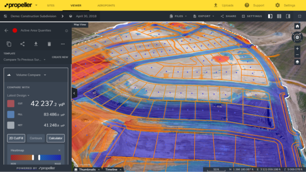
In complex projects like housing developments, adherence to design is a big issue—specifically, digging out housing plots and leveling them according to the linework. For repeated, fine-grained cut and fill work like this, 3D site visualizations are incredibly helpful. They provide a bird’s-eye view of either your whole site or of individual components, as needed.
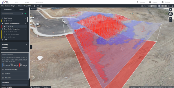
With Propeller’s simple tools, you can generate measurements that calculate volumes whenever you need them. On-screen calculators instantly show you the cubes for that region.
There are two primary methods for calculating cut and fill volumes using drone survey data:
Cross-section method/grid method:
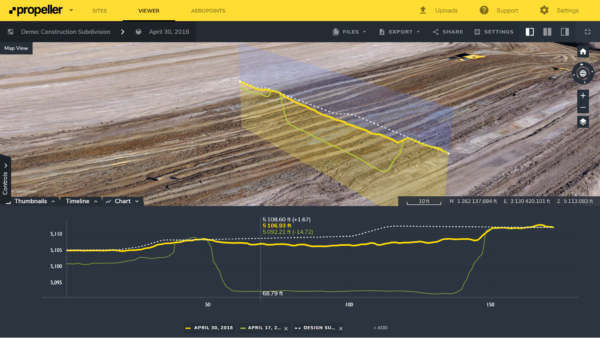
These colored lines correspond to each survey or surface you’ve uploaded into Propeller. As you move your mouse along those lines, you also get elevations.
3D view method:
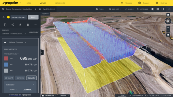
You can also view the site with 3D overlays of past surveys or your design to check progress. You’ll get a visual read on how much work has been done and how much is left to go, all without looking at a single spreadsheet.
Never move someone else’s dirt again
Cut and fill quantities equate to far more than simple volumes in the course of an earthwork project. They also factor directly into your bottom line by determining how you’re billed for moving earth. Too often, firms get stuck moving someone else’s dirt because the recordkeeping was sparse, or they couldn’t prove (or disprove) the amount of dirt a contractor actually moved.
Drone surveying lets you establish a virtual record with rock-solid quantities you can use as proof when disputes arise. Whether a general contractor is trying to get you to move their dirt, or you realize an initial topo provided inaccurate quantities for cut or fill at takeoff, you’ll get objective numbers from your drone survey and the Propeller Platform. And because measurements are easy to read and presented visually, there’s no room for disagreement on what the maps show.
Propeller takeoff reporting in action: a case study
Lange Land Surveying, a full-service land surveying company in Arvada, Colorado, used drones to complete takeoff reporting for their client, Remington Homes.
Typically, surveying a 25-acre lot would mean three days in the field. “With Propeller’s AeroPoints ground control hardware, and drone-mapping and analytics software platform, we’re able to fly the entire site in just half a day, so it’s saving us two and a half days of boots on the ground,” Jon Lange said.
With the 3D surface in Propeller, the LLS team uploaded and compared their data against the design and preliminary development surfaces. The drone flight showed more dirt on each lot than was initially budgeted by Remington Homes.
With this new data, the builder could account for the cost of moving additional dirt in the home price, amounting to $2,000–$3,000 in savings per lot. All in all, their client recouped roughly $187,000.
“We’re saving our clients tons of money and making our investment in Propeller back quickly,” Lange said.
Understanding cut and fill area helps at every stage of construction
Propeller helps construction teams perform accurate cut and fill calculations using drone-based site surveying and mapping. Request a demo to see how the platform supports faster, more reliable earthwork analysis.
Calculating cut and fill area accurately means reducing costs, preventing disputes, and keeping everyone on the same page. Export your takeoff reporting data or other earthwork calculations in easy-to-use CSV and PDF formats. You can also grant your team direct access to the Propeller Platform—it’s as easy as sending them a link or an email.
Frequently asked questions
Cut and fill analysis determines how much material must be removed or added to reach a desired elevation or design surface on a construction site.
Cut and fill calculations are performed by comparing existing terrain data to a design surface using survey data, often generated through drones or traditional surveying methods.
A cut and fill calculator is a tool used to measure earthwork volumes by analyzing elevation differences between surfaces and calculating material movement.
Drone-based calculations can achieve survey-grade accuracy when combined with proper flight planning and ground control, making them suitable for construction and earthworks projects.
They help control costs, prevent rework, and ensure that the correct amount of material is moved during construction.


