Fixed-wing & VTOL drones vs quadcopters for surveying: How to decide

Read Time: 4 mins
Quick links

    Fixed-wing, VTOL, and multirotor drones all have a place in construction site surveys, but which one fits your operation depends on three factors: site size, camera requirements, and total budget. Multirotors are compact and easy to deploy on smaller sites, while VTOL and fixed-wing platforms cover ground faster and suit large-scale mapping. Understanding the trade-offs between each type helps teams choose hardware that scales with their survey program.

    Advances in technology have made drones a practical tool for construction worksites. Modern platforms can achieve centimeter-level accuracy, and they’re far more accessible to deploy than traditional survey equipment. With the right setup, a site crew can run a drone survey without a background in conventional surveying.

    Drones are changing how earthworks companies capture site data. Whether you’re starting a drone survey program for the first time or scaling the one you already have, you’ll need three things in place: the right licences, the right software, and the right hardware.

    This guide covers the hardware side, specifically how to choose between the three main drone types for survey work.

    Lots of teams over-complicate this decision, which can result in a setup that’s expensive and hard to scale. It doesn’t have to be. Choosing the right drone comes down to three questions:

    • How large are your survey areas?
    • What camera resolution does your work require?
    • What’s your total budget, including long-term ownership costs?

    Here’s how fixed-wing, VTOL, and multirotor drones compare across all three.

    Fixed-wing vs VTOL vs multirotor drones

    Before comparing them, here’s what each type actually is.

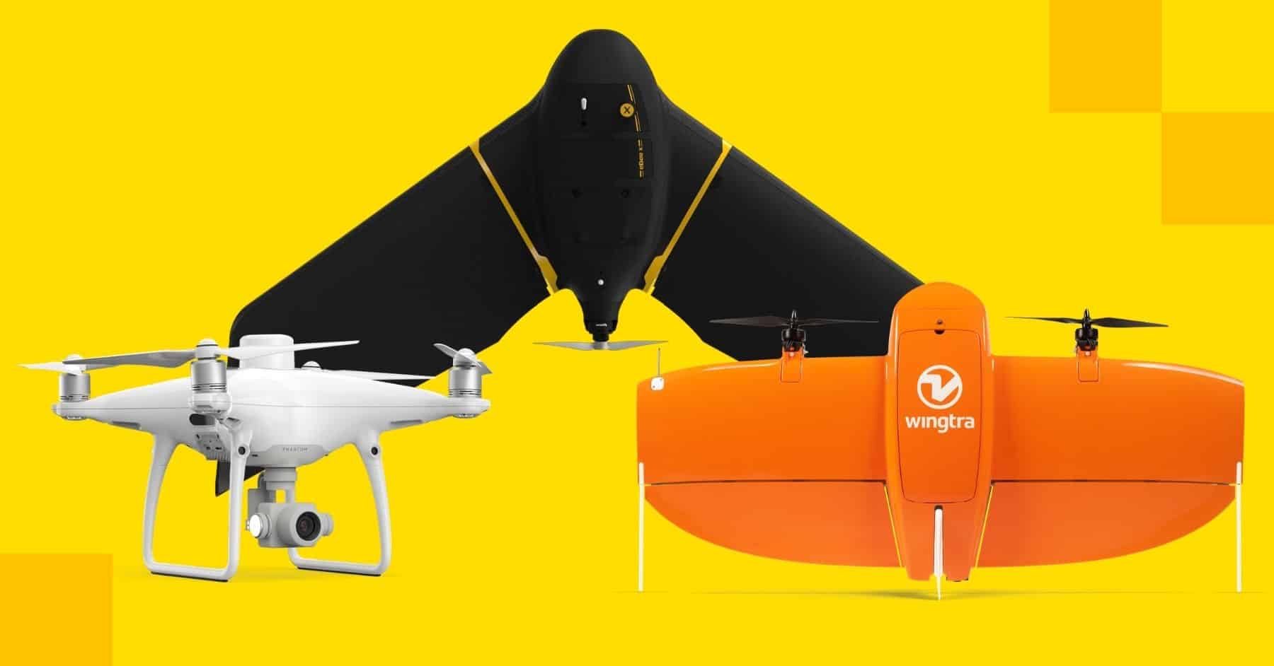
    Multirotor drones have a central body and multiple rotors powering propellers. They’re highly manoeuvrable, can hover in place, and take off and land vertically without a runway. The quadcopter is the most common configuration.

    VTOL (Vertical Takeoff and Landing) drones, such as the WingtraOne, combine elements from both designs. They take off and land vertically like a multirotor, but transition to fixed-wing flight once airborne. That combination gives them the efficiency of a fixed-wing platform with the operational flexibility of a quadcopter.

    Fixed-wing drones, such as the senseFly eBee X, look like small aircraft with a central fuselage, two wings, and one or two propellers. They fly fast and efficiently over large areas, making them well suited to high-volume survey work.

    Consideration #1: survey area size

    The size of your site is the most straightforward factor to evaluate.

    Fixed-wing drones fly faster and stay in the air longer than multirotors. On large worksites, one fixed-wing platform can cover the same ground as multiple quadcopters running in sequence. The trade-off is that they can’t hover, need more room for turns, and require a runway or clear landing area. For smaller sites or constrained environments, that footprint becomes a real operational problem.

    VTOL platforms like the WingtraOne are worth considering here. They take off and land vertically, then switch to fixed-wing flight once airborne, which removes the runway requirement while keeping the coverage efficiency of a fixed-wing platform.

    Multirotor drones have a clear advantage on smaller or more complex sites. No runway, no sweeping turns. They can ascend and descend on a vertical plane, which is useful when navigating around site infrastructure.

    VTOL drones can cover significantly more area per battery charge than a quadcopter of equivalent size. That efficiency advantage makes them the preferred choice for large-scale projects: highways, industrial complexes, quarries, and mines where re-flying sections or swapping batteries adds up quickly.

    As a general rule: if your site is under 200 hectares (500 acres), a multirotor will handle it comfortably. For larger worksites, a VTOL or fixed-wing platform is worth the investment.

    Consideration #2: camera selection

    A capable survey camera needs at least a 20 MP sensor, and the specs that affect ground sample distance (GSD) matter more than megapixels alone. GSD sets the physical limit on your survey accuracy. At 5 cm GSD, your map is accurate to 5 cm and no better.

    Both fixed-wing and multirotor platforms can achieve results accurate to a fraction of an inch with the right camera setup. The difference is in flexibility.

    Some multirotor platforms come with a fixed, integrated camera. That works well for most survey needs, but if your project requires a higher-resolution sensor down the line, check whether the platform supports camera upgrades before committing to it.

    Fixed-wing and VTOL platforms tend to offer more camera options. The ability to swap sensors means you can match resolution to the job, which matters when survey requirements vary across your project portfolio.

    For a deeper look at what to evaluate in a survey camera, read this guide.

    Consideration #3: budget

    Fixed-wing and VTOL platforms typically cost around 3.5 times more than a comparable multirotor. But the entry price is only part of the picture.

    Think in terms of total cost of ownership, not just what you pay upfront.

    Multirotors have more moving parts and tend to have shorter operational lifespans. Depending on how frequently you fly, you may be replacing a quadcopter every two or three years. Fixed-wing and VTOL platforms generally use more durable construction, with fewer high-wear components, which translates to a longer usable life before major maintenance or replacement.

    For a team flying infrequently or working primarily on smaller sites, a multirotor is the more cost-effective starting point. For a team running frequent large-scale surveys, the higher upfront cost of a fixed-wing or VTOL platform often works out cheaper over time.

    Summary

    For most teams starting out on smaller sites, a multirotor is the right call. It’s easier to learn, easier to transport, and more than capable of producing accurate survey data. For teams regularly flying large, open sites where speed and coverage efficiency matter, a VTOL platform is worth the investment.

    Here’s how the three types compare across the factors that matter most:

    Multirotor VTOL Fixed-wing
    Takeoff and landing Vertical, no runway needed Vertical, no runway needed Requires runway or launch area
    Best site size Under 200 ha (500 acres) 200+ ha (500+ acres) Very large, open sites
    Flight time Shorter Long Longest
    Hover capability Yes Yes No
    Camera flexibility Often fixed sensor Swappable options Swappable options
    Portability Compact, easy to transport Medium Larger, more complex
    Entry cost Lower Higher (~3.5x multirotor) Higher (~3.5x multirotor)
    Learning curve Easiest Moderate Steepest
    Quick links

      Related articles

      Two men in hard hats sat looking at the Propeller platform on a computer screen.

      How to Convert DWG to KML and DXF to KML

      Most people who use the Propeller Platform to measure and manage their worksites also work with different…
      Why AeroPoints Don’t Use RTK

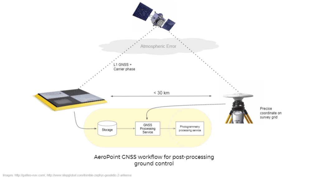
      Did you know: AeroPoints™ don’t use RTK to process and correct positioning data. So what is RTK GPS,…
      Screenprint-style illustration of a drone's shadow approaching a checkered ground control target on textured earth

      Drone surveying 101: How it works and what to expect on your first flight

      Drone surveying captures site-wide elevation data in a single flight, typically processed into a centimeter-accurate…

      Ready to learn how Propeller can power up your worksite?

      We’re happy to show you how Propeller can power your worksite, and boost productivity.

      Related articles

      DJI GS Pro: Drone Mission Planning

      GS Pro (Ground Station Pro) is the latest app developed by DJI to plan and…
      Two drone pilots in a field ready to start a flight. AeroPoint is in the foreground.

      Mastering Foundations of Drone Surveying

      Foundations of Drone Surveying Course – Get Training in UAV Surveying Propeller partner UAVAIR provides…
      A drone pilot stood holding an Aero Stencil.

      Marking Semi-Permanent GCPs with AeroPoints and AeroStencils

      Do you fly the same site frequently? If so, you can save the time spent…