The variety of cameras available in the drone world may seem overwhelming. New models are launching all the time, making selecting the right camera unit for surveying and inspections even more complicated.
In this guide we are focusing on critical camera features to consider when selecting photographic equipment for surveying and inspections.
Ground sample distance
To start with, let us bring you back to one of our recent posts on drone data accuracy and remind you about the ground sample distance (GSD) as one of the factors affecting the precision of your maps and models.
The GSD is the real-world size of a pixel in your images. This sets a physical limit on the accuracy of your aerial survey. If your GSD is 5cm, the map or model is accurate down to 5cm and no more. The GSD is measured in cm/pixel and is usually ranging from <1 to 5 for aerial surveys.
Ground sample distance is defined by several variables:
- Altitude of the image capture
- Size of camera sensor
- Camera resolution
- Focal length of the camera lens
- Aperture
When selecting a camera model for drone surveys and inspections, pay your attention first to those camera specifications that directly affect GSD.
Camera specifications affecting GSD
1. Camera resolution
Camera resolution is the amount of pixels the sensor will map. The rough range of UAV camera’s today varies between 2–50Mp. Higher-resolution camera units will achieve a greater GSD for an equally sized camera sensor as compared to lower resolution.
However, higher camera resolutions doesn’t necessarily mean an absolute advantage. Higher megapixel resolution combined with small sensor size can subject your images diffraction effects, meaning images will be less sharp.
2. Sensor size
Sensors come in various standard sizes: 2/3”, 1”, Micro 4/3rds, APS-C, and full frame. Larger sensors have better light-gathering ability at the same resolutions, while smaller sensors need longer exposure times to achieve the effective outcomes.
3. Camera aperture
The aperture defines how much the sensor is exposed to light.
If the aperture value, usually marked by f, is fixed it will directly affect images captured by a camera.
UAVs cameras often have low fixed aperture value (e.g., f 2.0), which places all objects a few meters away from camera in an infinity focus region. Low-resolution cameras won’t be able to resolve points apart once the point of interest (the ground) is too far away.
When your camera does not have variable aperture it will have to extend exposure times accordingly resulting in blurry images. Adjusting the aperture value helps to match lighting conditions to effectively expose sensor and obtain the sharpest images.
You should also consider the diffraction effect. If the aperture is fixed in small position (high f-number) and the pixels are small (high resolution on small sensor size) the diffraction effects will cause light to fall on multiple pixels and overall sharpness of your image will decrease.
Sharp images with defined pixel contrast are crucial to the creation of good 3D point cloud models.
4. Focal length
Focal length is a combination of sensor size, an effective distance from mirrors within the lens and the curvature of the glass.
Drone cameras offer various lens options that can cover anything between 10mm to 1200mm effective focal length. Long focal lengths usually linked with lower resolution and used for visual inspection purposes not offering any great advantages for surveys and 3D generated asset inspections.
Important camera specifications for inspections
For drone inspections it is crucial to have a high resolution camera, with a larger sensor and a 35mm equivalent focal length which allows you to:
- Provide more details about any point of the inspected object
- Increase image contrast to help you generate better 3D models and point clouds
Another important point to consider for inspections is camera articulation. If you need to inspect objects like bridges or overpasses from underneath, make sure that the gimbal is fully articulated and is able to point camera in any direction.
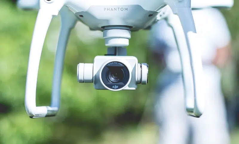
Larger drones like DJI M100/M600 and some custom-built drones have fully articulated cameras which work well when you are inspecting points from underneath it, or any point where the camera must point upwards while smaller drones like Phantom 4 or 4 Pro can’t deliver this.
The other consideration for inspections is autofocus. Preferable cameras will have a quick autofocus and short focal length so when you are above 20m everything will be in the infinity focus region. The more focus points the camera has does not mean it will work better it might try too hard to achieve this and cause blurred images.
Important camera specifications for surveys
Similar to inspections, higher resolution cameras and larger sensor sizes are always going to help you to produce superior results. Higher resolution camera will increase the GSD meaning you can fly higher for the same results. This is particularly good when high levels of interference maybe present on the ground.
For surveying purpose, consider a camera with mechanical (global) shutter. It will reduce the rolling shutter effect from fast motion, which causes heavy distortions to the photographs and significantly decreases the accuracy of 3D generated models.
As the market evolves, the choice of cameras available for surveying and inspections will increase even more. Understanding of your long-term data needs and accuracy requirements will help you to set the priorities and find the best camera type for your regular flights.
However, for those running a pilot drone project or if size, portability and the price are the main concern, the Phantom 4 Pro or Phantom 4 RTK, is the best option available now.
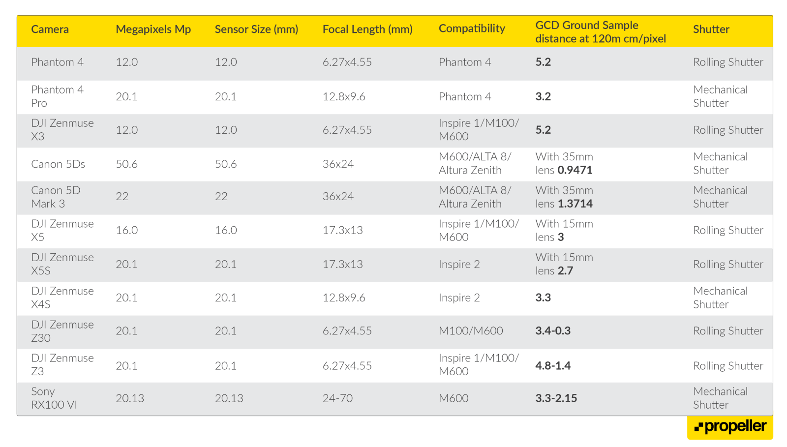
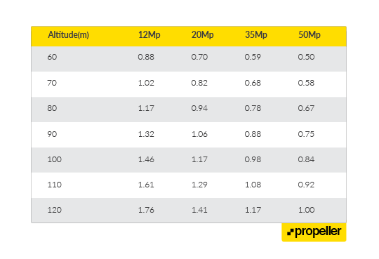
See the table below for more popular camera options: