Anticipate flooding risks or drainage issues before they cause delays or added cost

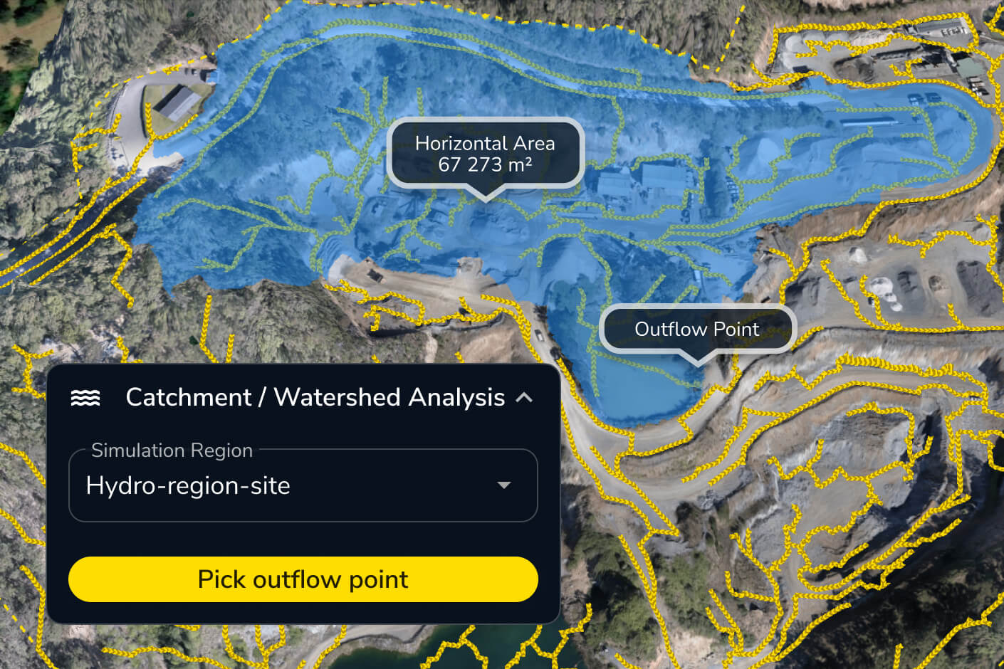
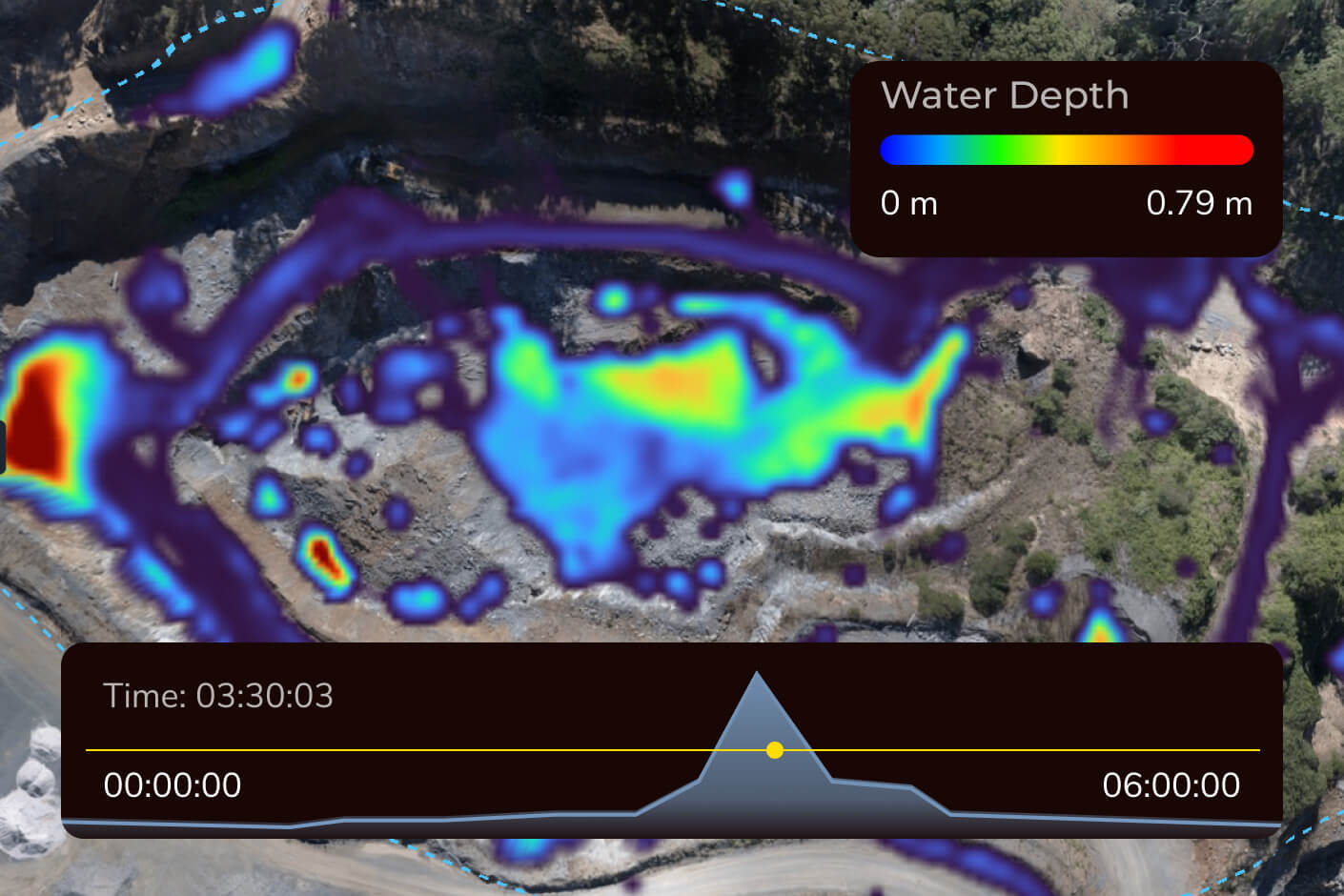
Keep your projects moving with clear, up-to-date insights into rainfall, runoff and drainage.

hydrology drainage for construction sites

Understand your site’s drainage patterns

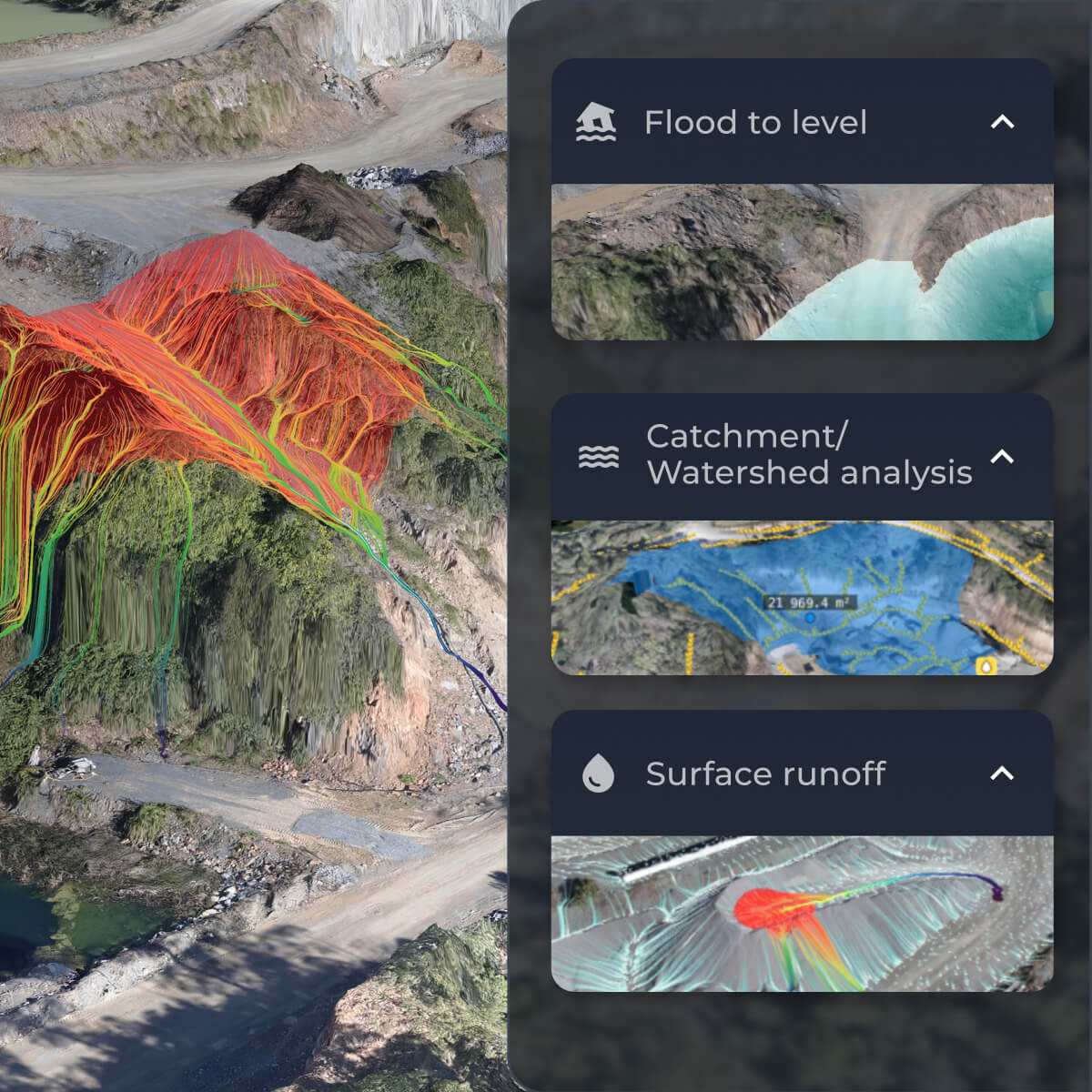
Visualize water flow patterns, drainage patterns, and flood levels so you can take proactive action. Identify construction site water management issues before they cause erosion or equipment damage and prove environmental compliance with catchment area regulations.

Stay ahead of water risks before they cost you

Poor drainage patterns and unexpected flooding can bring work to a halt. Prepare, prevent, and protect your worksite with Propeller’s flood risk analysis tools.

Analyse surface runoff on site

Get accurate surface runoff visualisations for your site with Propeller.

Predict with precision

Make informed decisions early and protect your site from avoidable delays.

Stay compliant with regulations

Document compliance with environmental compliance plans, drainage regulations, water management plans, environmental permitting, site water control, and flood risk assessments—without extra work.

Simulate surface runoff to prevent erosion

  • See how water will flow across your site during rainfall, spills, or major storms
  • Flag areas prone to pooling, flooding, or erosion risks
  • Plan better drainage patterns to prevent downtime or structural damage using runoff simulation
Features
  • Surface runoff
  • Direct rainfall simulator
  • Flood to level
  • Utilisation view
flood risk pattern analysis for assessment on a worksite
showing the run off volume and drainage pattern on a worksite

Analyse catchment area capacity to manage drainage

  • Identify natural catchment areas that feed into specific outflow points
  • Assess how well current systems handle runoff volume
  • Plan drainage network improvements to prevent flooding
Features
  • Catchment area analysis
  • Elevation difference
  • Surface runoff
  • Crop and cleanups

Predict runoff impact with rainfall simulation

  • Simulate different rainfall intensities to predict where water will flow and pool
  • Evaluate grading and drainage effectiveness under different weather conditions
  • Adjust equipment locations and mitigation strategies with precise flood risk assessment
Features
  • Direct rainfall simulator
  • Smart cycles
  • Flood to level
  • Timeline
run off simulation for stormwater compliance
flood risk pattern analysis for assessment on a worksite

Analyse flood levels and create mitigation plans

  • See which areas will be impacted at different flood levels
  • Identify high-risk equipment storage or work zones
  • Develop proactive flood control and flood risk assessment plans to minimise downtime
Features
  • Flood to level
  • Hazards
  • Surface area
  • Area progress
drone flying over a construction site

“We started using Propeller to capture weekly project photos for the client and track waste material quantities as we reprofiled the landfill. By modeling the existing site, we could compare it to the final design, track cut/fill balance, and monitor progress throughout the project.”

– Jonathan Wills, Director at Wills Bros

Cross Section Survey in a Matter of Minutes Using Drone Data

With the power of drone-captured data and the Propeller Platform, surveying cross sections becomes as…

How to Use Drone Data to Improve Landfill Performance

If you manage a landfill, you may have been wondering how you can use drones…

How to Collaborate Better Using Drone Data and the Propeller Platform

Keeping everyone on your worksites up to date with the best and most recent information…

Connect Propeller to your existing workflows

Seamlessly integrate Propeller data, including digital elevation models, with your favorite tools. Automate reporting, streamline operations, and maximize efficiency.