Propeller and Trimble
Morehart Field Services is using Trimble Stratus, Powered by Propeller. Trimble, the global leader in positioning technologies, was an early partner of Propeller. Our teams work closely together to deliver Trimble Stratus survey-grade drone data solutions for the heavy civil industries.
Daniel Morehart operates DKM Construction, an excavation construction company based in Greenbrier, Arkansas. He has experienced, firsthand, the benefits of drone surveying technology for his projects. Reduced time and costs by surveying with a drone have translated into savings for his clients and have given him a competitive edge for his company.
Realizing this innovative technology wasn’t readily available in Arkansas, he formed Morehart Field Services to satisfy the demand for aerial site surveying. Morehart Field Services specializes in original ground topography measurements. Their customers seek accurate elevation data for their site work that they can then import into their AutoCAD programs and complete their workflows. Customers can also use their drone data as a visualization tool and as the basis for reports that show how their worksites are progressing.
Daniel’s son, Bryce Morehart, is the vice president and chief drone pilot for Morehart Field Services. He also serves as the drone pilot for a majority of jobs at DKM that points out to their clients the need for fast, accurate surveys to ensure work progresses on time and within scope. Bryce previously worked solely for DKM Construction, handling machine control and managing site surveys traditionally with a base and rover. Now, via drone surveying and processing photos with Trimble Stratus powered by Propeller, he can accurately measure cut/fill quantities for his customers. He’s been using the platform for approximately a year and a half, and shared what it was like gathering site data before using Propeller.
“I would go out on site and set up the base station, calibrate the site, and make sure that all the machine operators received the proper updates whenever the site plans changed,” Bryce said. “I always had my suspicions about the accuracy of surveying with a base and rover, and with having such a small sample of data over the field. I could go out and pick a bunch of points, but they could easily not represent what’s actually out there, depending on where you put those points. We reached out to our partners at SITECH, and they introduced us to Trimble Stratus, and it was great for us in building our drone surveying business.”
Winning bids with better data
Bryce explained the importance of accurately bidding for work as a dirt contractor. Prior to drone surveying, it was difficult to gain an accurate gauge of how much earth needed to be moved, especially if working from an outdated plat of survey.
“By being able to survey a prospective site with a drone, I feel you are able to bid for a job more accurately,” Bryce stated. “Contractors and civil engineers don’t like surprises, and by flying a site beforehand, you can get a more accurate cost analysis on the front end. Trimble Stratus also gives my customers, who aren’t familiar with CAD files, a way better understanding of what’s going on, and they can better visualize their site.”
Exportable data
The processed data Bryce obtains from Trimble Stratus powered by Propeller can be easily exported and sent to his customers for further review and analysis. He doesn’t have to worry about sending large DXF files through email. “Trimble Stratus has made that [data exporting] really simple,” Bryce explained. “My clients can just export the file from the Propeller Platform and place it in their programs, and it works great for their workflow.”
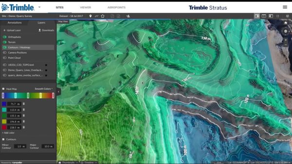
In addition to the contour and elevation maps, Bryce’s customers often use the platform’s hydrology feature, as they regularly have to prepare and plan for significant weather events that could impact their workflow and project progress, including flowing and standing water due to heavy rainfall. With Trimble Stratus, they can measure and analyze the potential impact of these sometimes unforeseen events across the worksite.
“One of the construction companies I work with has problems with parking lots and their drainage,” Bryce shared. “And when they have a problem, they come back to us because the hydrology feature in Propeller helps them solve the problem pretty easily.”
Quick reporting
Trimble Stratus allows Bryce to collaborate closely with his customers because he receives his drone survey data back within 24 hours and is able to review the processing report before sharing it with them.
“I try to look at the survey data from my customer’s point of view because that’s ultimately what I’m concerned about. The processing turnaround time is better than I had expected, and that’s one of the biggest advantages with Trimble Stratus. When people come to me, the two biggest things they want is more data and a larger sample size, which ultimately leads to better accuracy and turnaround time. They don’t want to wait two weeks, and they are usually impressed with how fast they receive their site maps back from me.”