Cut & fill software for accurate earthwork volumes

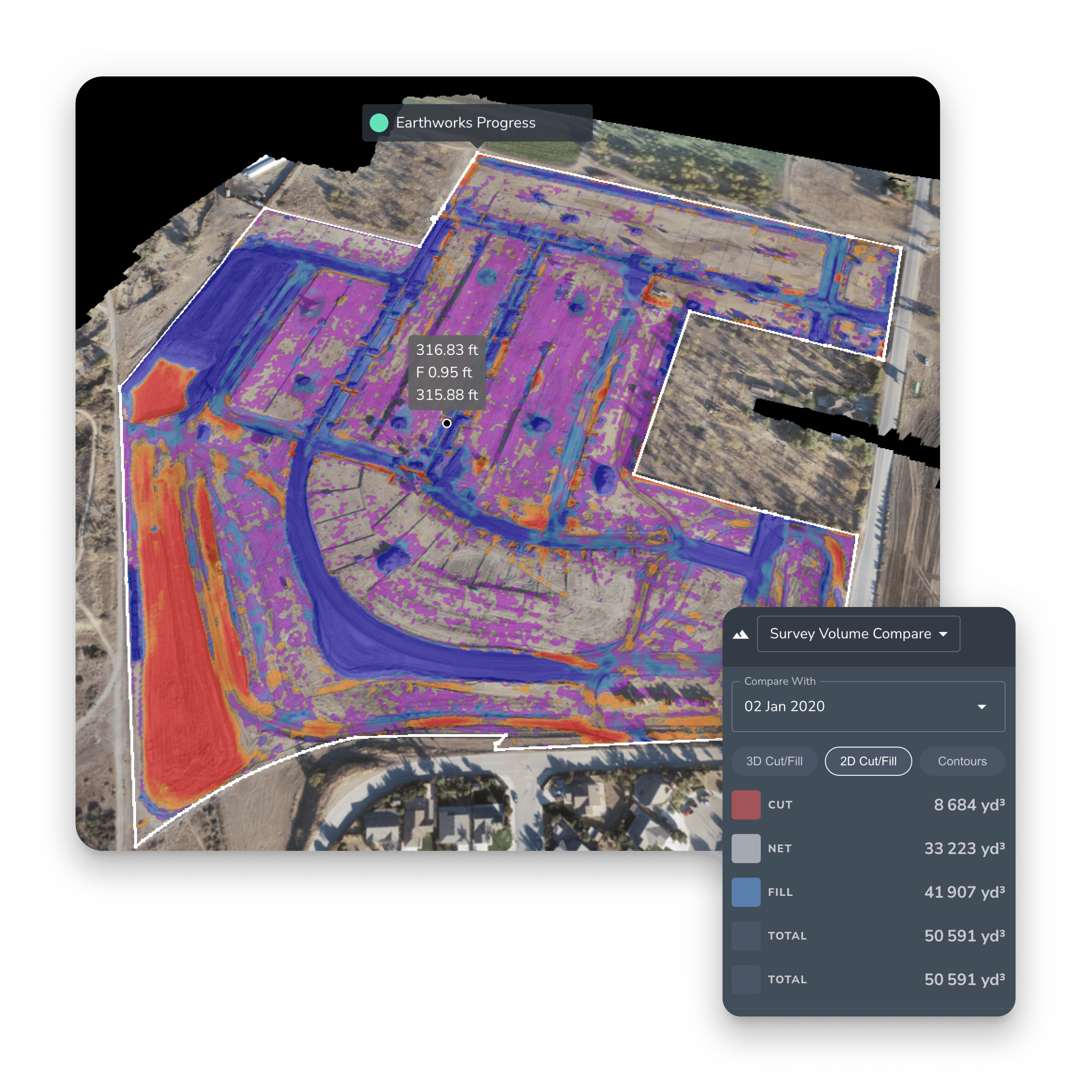
Stop guessing and start measuring. From cut and fill analysis to precision volume calculations, Propeller gives you the ground truth in 3D.


Managing a site means managing change. Whether you are looking for the best cut and fill software for initial bids or need earthwork progress monitoring software to keep your project on budget, we’ve got you covered.


Get all teams from the office to the field aligned with a single digital terrain model for all your cut and fill volume calculations.

1K
Worksites powered by Propeller
1K
Users collaborating on the map
1K
People powered by Propeller

Precision earthwork tracking from pre-construction to as-built

Propeller’s earthwork estimating software transforms standard drone cut and fill surveys into actionable data. We don’t just give you numbers; we give you a visual cut fill heatmap that shows exactly where material is moving.

  • Cut fill surface comparison: Compare your digital terrain model (DTM) against design files to see exactly how much dirt is left to move
  • Mass earthwork calculations: Get earthwork volume calculations in seconds, not days, reducing the time spent on manual earthwork quantity takeoff
  • As-built vs. design: Use our terrain change detection drones to ensure your site grading cut and fill matches the original plan perfectly
earthwork progress tracking within the Propeller platform
Person reviewing load and dump counts and cutfill metrics in Propeller

Built for the field, trusted by the office

We designed our civil earthwork cut and fill tools for the people who actually use them.

For project managers & site managers

Stay on top of your margins with earthwork tracking software for PMs. Our cut and fill reporting software makes it easy to communicate progress to stakeholders. No more disputes, just clear cut and fill maps and data-backed cut fill quantity calculations.

For civil engineers & estimators

Need a cut and fill takeoff software that integrates with your workflow? Propeller supports civil 3D exports and provides high-fidelity cut fill analysis that simplifies civil cut and fill requirements.

Why choose propeller for drone cut and fill analysis?

Our drone-based cut and fill software isn’t just a tool, it’s your eye in the sky.

  • Cut fill balancing calculations: Easily determine if you have enough material on-site or if you need to haul
  • Precision earthwork mapping: High-resolution 3D cut and fill visualization allows you to spot errors before they become expensive re-work
  • Automated earthwork surface analysis: Move away from manual spreadsheets and embrace cut and fill calculation software that does the heavy lifting for you
DirtMate dashboard highlighting the work of 2 bull dozers on a worksite

Ready to see our cut and fill software in action?

See how our earthworks cut and fill software can transform your site operations.

REQUEST A DEMO