Part One—Hardware
Since the invention of the total station in the early ’70s and the base and rover in the ’90s, surveyors hadn’t had any major advancements in their tools until very recently.
Thanks to cloud computing and affordable commercial drones, we are witnessing the next step-change in the surveyor’s toolkit. When used correctly, they can help surveyors get their job done faster and safer than ever before, without compromising on accuracy.
There are many options available to surveyors in this space in terms of hardware and software, and it’s important that you get the right set up from the beginning to maximize the return on your investment.
In the same way that a hammer won’t help you undo a screw, there are different combinations of hardware and software for different drone surveying jobs. This article is to help you select the right tools for the job you’re doing.
To drone or not to drone?
To start with, are drones even appropriate for your job?
Drones are great tools for surveying:
- Complex terrains
- Hard to reach areas
- Large areas faster and/or safer
Drone are not well suited to:
- Projects that need better than 10mm accuracy
- Sites in restricted airspace or close to airports (unless you are authorized to fly there)
- In these situations, you will need to check whether you’re going to be able to fly drones there at all
- Areas that aren’t visible from the sky
- Ground completely covered by snow, vegetation or roofs (in sheds, etc.)
- There are exceptions to these rules. Feel free to contact us to find out more
- Areas greater than 1,000 hectares (manned aircraft are currently more appropriate for areas this big)
Selecting a drone
Assuming that drones are appropriate for your job, the first thing you’ll need to figure out is which drone(s) to get. There are various options available, and several key factors that you should take into consideration when making your purchase.
Thanks to the benefits of mass production and consumerization of drone technology, you can get great, inexpensive drones which often outperform more expensive units.
We believe in selecting the right tool based on the merits of the platform, rather than its cost.
Fixed wing or multicopter?
The first question is whether you want a fixed wing or multicopter UAV. The main things to consider are:
- How big is the area you’re surveying (per survey)?
- Any less than 200 hectares (500 acres) can be done comfortably with a multicopter.
- Any more, you may want to consider either:
- More than one multicopter; or
- Fixed wing UAV
Please note that if you are operating in a constricted area, you may not be able to use fixed-wing aircraft due to their spatial landing requirements.
- Budget:
- Multicopters (especially those made by DJI) are mass produced and so can be purchased easily and cheaply.
- Fixed wing UAVs are still made in limited quantities and thus units are significantly more expensive (up to 100 times more)
What country are you operating in?
USA:
The aviation regulations have recently changed to allow people to fly drones under 55lbs for commercial purposes (during daylight hours, within line of sight, under 400ft and under 100mph) after passing a UAS specific aeronautical exam (FAA 107).
More info on licensing in the USA.
Canada
You can fly drones under 2kg for commercial or research purposes without requiring special permission, as long as they fly under 300ft, in daylight hours, maintaining visual line of sight and avoid restricted airspace.
Australia:
Thanks to fairly recent changes in legislation, anyone can fly a drone that is under 2kg commercially without a licence.
Most of the drones suggested below meet this requirement.
Keep in mind that some areas have tighter restrictions (like near airports, helipads etc) and you need to get a special authorization to fly there/fly below a certain altitude.
More info on licensing in Australia.
Other countries:
RTK?
Since the drone is so high above the ground, all of your standard sources of GPS error (multipath, lock, receiver noise, atmospheric delay, etc.) are amplified when trying to calculate the position of each pixel on the ground.
There are several ways to reduce these errors. The easiest, but most expensive way is by purchasing a drone with on-board real time kinematic (RTK) satellite navigation.
If you only need 40–150mm accuracy on your survey and have the budget, this is the most time effective way of getting the job done. We expect the price of RTK enabled drones to come down eventually, but starting at around $24,000 USD, they’re typically used on high-value sites or where flying most efficiently is an important consideration.
The most cost effective option is to use ground control, which will actually get you closer to survey grade: 20–30mm accuracy is easily achievable. Placing ground control points (GCPs) can be time consuming so this must be factored into total time saved.
The best accuracy you can get is combining ground control with on-board RTK, which should get 10–20mm accuracy under the right conditions. Unsurprisingly, this is also the most expensive option.
It’s also worth noting that having RTK on board often reduces the number of ground control points you need to achieve the same accuracy.
Brand?
Now that you’ve decided on whether to go for a fixed-wing or multicopter, and whether you want RTK on board, now is a good time to start thinking about which manufacturer to go with.
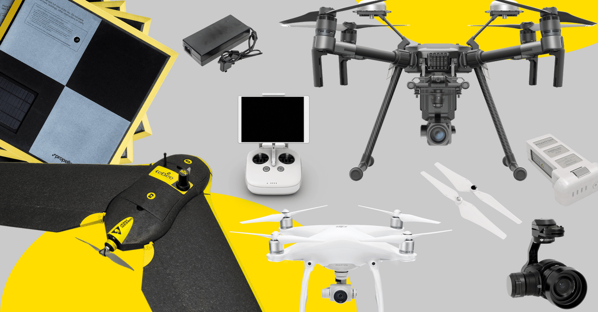
For fixed-wing aircraft, we recommend the SenseFly’s Ebee Plus. It is a well-built, capable, and reliable platform and is available with or without on-board RTK.
For multirotors, DJI accounts for more than half of multirotor sales worldwide and for a good reason. The build quality of their drones is on par or better than other manufacturers, the on-board software and accompanying apps are well developed and intuitive and they are available at a reasonable price.
For almost all photogrammetry requirements, we recommend:
- DJI Phantom 4 Pro (no RTK)
- DJI M210 RTK (has RTK), set for release in Q4 2017 (note that this is over 2kg)
If you plan on getting a DJI drone, we recommend going for the standard controller and an iPad mini, rather than the controller with the integrated screen. This is because all flight control applications are built for Android and iPad rather than for the integrated screen.
To go deeper into drone selection, feel free to check out this guide on DJI solutions for commercial operations.
Camera
Good camera for surveying purposes should ideally have a 20Mp (or better) sensor. Avoid getting cameras with interchangeable lenses unless you are 100% sure you will need this feature. They over complicate the surveying process and often worsen the quality of the data with images that can be out of focus.
If you want to go deep on camera selection, have a look at this article on what makes a good camera for drone surveys and inspections
Batteries
Carry spares! You’re better off having too many than not enough, and drones chew through batteries very quickly (typically 20–25 minutes flight time per battery).
As a (very) rough rule of thumb, you’ll cover around:
- 25 hectares (60 acres) per battery with a multirotor
- 50 hectares (120 acres) per battery with a fixed-wing
Ground Control
Ground control is your key to survey-grade accuracy whether you’re using onboard RTK or not.
The only times you don’t need ground control are when:
- 5–10 meter accuracy is acceptable (the result you can get relying on inbuilt GPS)
- You have RTK on board of your drone and 40–150mm is acceptable
Non-Active Areas
For all unchanging areas like around the perimeter of a pit or site, the most cost and time effective approach is using fixed ground control by marking the position permanently and recording its location.
Learn more about marking semipermanent GCPs here.
Active Areas
You can also manually mark out your ground control points in active areas like in a pit, active landfill cell or construction site, although there are two major drawbacks of using traditional ground control in these scenarios:
- They can take a long time to mark and record, which isn’t practical when you need to keep doing them each survey.
- You run the risk of your ground control being obstructed, destroyed or moved, which would mean losing that day’s worth of data.
This is why AeroPoints were invented, which are rugged, portable and smart ground control points that work in any location and don’t require charging (they have solar panels and batteries built in).
To set one up, you put it on the ground and press the button. That’s it. If they get moved while recording, our software automatically detects and corrects it.
Continue reading to Part Two. . .


