You’re about to fly a site covered in brush. The terrain hasn’t been touched yet, and you need accurate existing ground data before the first machine moves. Which method do you reach for, and what happens if you choose wrong?
That’s the decision this post is built around. Not a deep-dive on sensors and physics, but a practical guide for site managers, surveyors, and PMs who need to make the right call before a bid, a pre-con survey, or a first flight. Both methods produce high-precision data. But they don’t produce the same data. On the wrong site, that difference shows up in your cut/fill estimates, your bid numbers, and your rework costs.
What each method actually does
Two tools, two different answers.
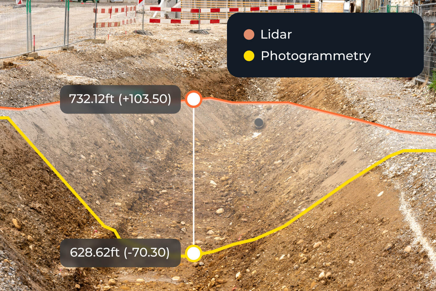
Photogrammetry works by processing overlapping aerial images into a 3D model. The camera captures what it can see. That’s the key constraint. On a cleared site, what the camera sees is the ground. On a vegetated site, what the camera sees is the top of the canopy.
LiDAR (Light Detection and Ranging) fires laser pulses at the surface and measures the return. Because some pulses pass through gaps in vegetation and reflect off the ground below, LiDAR can capture the actual terrain surface even when it’s obscured. It reads what’s there, not just what’s visible.
The vegetation problem (where the decision usually lives)
The wrong tool on the wrong site compounds fast.
On a cleared, graded site, photogrammetry is fast, accurate, and cost-effective. It’s the right tool for the job.
On a site with dense brush, scrub, or tree cover, photogrammetry maps the canopy, not the ground. That might seem like a minor technical distinction, but the downstream consequences are real: your volume calculations reflect the top of the vegetation, not the existing ground beneath it. Your cut/fill estimates are off before work even starts. Your bid is built on a surface that doesn’t exist.
This is where LiDAR earns its place. By penetrating through gaps in the vegetation and capturing original ground data, LiDAR gives you the terrain model you actually need for accurate earthworks planning, bid preparation, and pre-clearing assessment.
That said, it’s not a binary choice. A GPS manager at a large civil contractor described using drone photogrammetry to survey rough, ungrubbed sites before bids and during pre-construction — reducing survey time from two to three days down to one to two hours, and preventing potential losses of $1,800 to $6,000 per bid by getting accurate dirt quantities before breaking ground. Their words: “With a drone flight, we can go into a site before a bid or during precon and say with confidence how much dirt is there.”
The takeaway: photogrammetry can work on rough or partially vegetated terrain, especially when canopy cover isn’t blocking the ground entirely. LiDAR becomes the clearer call when vegetation is dense enough to meaningfully obscure existing ground.
![]()
Side-by-side comparison
| Photogrammetry | LiDAR | |
|---|---|---|
| Best for | Cleared or exposed sites, progress tracking | Pre-clearing, vegetated terrain, bid prep |
| Works through vegetation? | No (maps canopy surface) | Yes (captures ground through gaps in cover) |
| Typical accuracy | High on exposed ground | ~5–6cm horizontal on vegetated terrain |
| Hardware needed | Standard drone with RGB camera | LiDAR-equipped drone (e.g., DJI Zenmuse L1/L2) |
| Processing complexity | Standard | Higher (PPK correction, classification, QA/QC) |
| Output types | Orthophoto, DSM, point cloud | DTM, DEM, point cloud, orthophoto |
| Relative cost | Lower | Higher (hardware and processing) |
When to use each
Match the method to the site conditions.
Use photogrammetry when:
- The site is cleared or vegetation is sparse enough that ground is visible from above
- You need high-frequency surveys to track progress against design
- Budget is a primary constraint
- Surface detail and orthophoto output matter as much as ground elevation
Use LiDAR when:
- You’re doing a pre-clearing or pre-construction assessment on a vegetated site
- You need accurate existing/original ground data before earthworks begin
- You’re preparing a bid where ground truth matters and the canopy can’t be trusted
- You’re assessing overburden in a mining context, or surveying a capped landfill area
Use both when:
- Your site has varied conditions (some areas cleared, others not)
- You need a pre- and post-clearing comparison to validate what was captured
- You want full terrain context for both planning and ongoing progress tracking
Accuracy: what the numbers actually mean on site
Precision only matters relative to the use case.
LiDAR processed through Propeller with DJI Zenmuse L2 delivers approximately 5–6cm horizontal accuracy. That’s not suitable for foundation or as-built precision work. But for pre-clearing earthworks planning and bid preparation, it’s the right tool for the job.
Here’s why the number matters: on a 50,000 CY earthworks job, an inaccurate existing ground model doesn’t just affect your estimate, it compounds. Bad volumes mean bad cut/fill projections, which mean bad bids, which mean margin erosion before a single machine turns a wheel. Getting the existing ground right before clearing starts is where LiDAR pays for itself.
Photogrammetry, on exposed ground, delivers higher surface accuracy, making it the stronger choice once clearing is complete and you’re tracking progress against design.
What about cost?
Compare it to the right thing.
LiDAR hardware and processing costs more than photogrammetry. That’s straightforward. The question is what you’re comparing it against.
A traditional ground survey on a heavily vegetated site takes days, requires a crew on site, and still may not capture what’s under the canopy. A bad existing ground model on a complex bid can cost far more in rework or margin loss than the LiDAR flight that would have prevented it. The cost comparison that matters isn’t LiDAR vs photogrammetry. It’s LiDAR vs the consequence of not having accurate ground data.
How Propeller supports both
One platform, both workflows.
Propeller processes both photogrammetry and LiDAR data, and both workflows live on the same platform. That means you can combine a pre-clearing LiDAR capture with ongoing photogrammetry progress surveys and compare them directly. Same viewer, same map, no switching between systems.
For LiDAR, Propeller handles PPK correction, denoising, strip alignment, classification, and QA/QC. Supported hardware includes the DJI Zenmuse L1 and DJI Zenmuse L2 on the DJI M300, M350, and M400.
Learn more about LiDAR processing at Propeller
See how photogrammetry workflows fit into the platform
Not sure which method fits your next project?
We can help you match the right capture method to your site conditions before you fly.