
New to using drones in construction projects? Start here.
Drones have never been more affordable or accessible for worksites. While they may seem like high-tech pieces of equipment—and they are—the use of drones in construction has become as common a sight as a GPS rover or total station.
Unlike traditional surveying equipment, however, you don’t need hours of special training or advanced technical knowledge to use them and the data they collect. Drones have become the key to fast and frequent site surveys, giving you access to more data, faster, while maintaining the high accuracy standards you rely on.
But collecting and processing your data is only half of the story.
A successful construction site drone program needs software to make sense of all that data, giving you accurate and actionable information about your site’s progress and productivity. Powerful web-based platforms like Propeller translate your raw drone data into a format anyone can read and use in their daily work.
The other half of the equation? Interactive 3D site maps you can use to measure and manage your worksite. Fully navigable. Fully measurable. Run in your browser, so no one needs special software or a high-powered computer to use them.
When anyone can log in and make measurements or check for hazards, drone surveying software helps ensure high-quality work throughout the life of a project, minimizing operational risks and costs.

Key components for the successful use of drones in construction
To launch a successful drone program, you’ll need two critical ingredients: the right hardware and the right software. We’ll explore these one by one further down.
But first, a word of warning. It’s not unusual for organizations to overemphasize hardware when they’re first starting out. This often overcomplicates things, leading to unnecessary spending on things like custom drones or long-term leases.
The problem with these approaches is scalability. Without a solution that’s easy to replicate on other sites—or train new workers to use—you can’t easily scale your drone program alongside your business needs.
A successful drone program should be simple, scalable, and economically efficient.
Step 1: Choose the right drone hardware for your worksite
There’s no shortage of drones available to choose from, which can feel overwhelming at first. To pick the one that’s right for your needs, consider a few factors. How big is your survey area? What’s your budget? What image resolution will you need for your surveying purposes?
Drone type
If your site is smaller than 200 hectares (500 acres), you can survey comfortably with an RTK-enabled multicopter, which tend to be less expensive than their fixed-wing counterparts. If your site area is larger, you may want to consider either multiple multicopters or a VTOL drone.
That said, if you’re operating in a restricted area or a busy workspace near moving equipment, weight restrictions might limit the type of drone you can legally fly. If you’re flying near uninvolved people or urban areas, you’ll likely need a lighter drone.
Location accuracy
Either way, there’s another must-have to consider: RTK. Real-time kinematic (RTK) capability makes the difference between pictures of your worksite and survey-grade data accuracy. RTK processing records GPS information and geotags images with higher precision as they’re captured during flight.
In Propeller’s PPK workflow, the drone and AeroPoints collect data independently and simultaneously, and the data is corrected post-flight. The drone’s data is then compared to smart ground control points/base stations on the ground to accurately determine the position of each data point in space. (RTK drones can also be used with standard ground control to achieve high-accuracy results.)
Propeller PPK is by far the easiest way to achieve 1/10ft accuracy site-wide consistenly, using only one AeroPoint as ground control.
Survey-quality camera
For surveying purposes, a good camera should have a 20MP (or better) sensor. You need high sensor quality to capture high resolution, also called ground sample distance (GSD). The GSD is the real-world size of a pixel in your images, which sets a physical limit on the accuracy of your aerial survey. For example, if your GSD is 5cm, the survey produced can only achieve 5cm accuracy at the highest, and will likely average closer to 7-8cm.
<Check out Propeller’s camera guidelines for more information on surveying cameras>
In general, make sure you have a high-resolution camera with a larger sensor and a global or mechanical shutter. This lets you capture more detail about any point and increases your image contrast to help generate better 3D renderings.
Step 2: Choose the right software for your drone surveying needs
As we’ve seen, there are various options available on the hardware side. While there are decisions to make, you can usually rig together a combination of tools to acquire the data you need.
Software, however, is a different matter. It’s not an interchangeable tool. Construction jobs are complex, involving many levels of oversight, design, and management. You need to pick the software that’s right for your workflows.
In this section, we’ll cover the most critical workflows to help your business spend less and earn more.
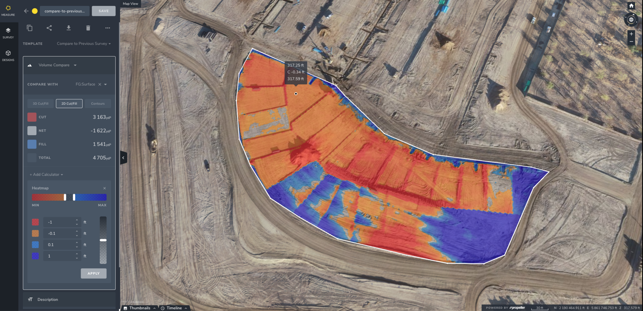
Calculate volumes quickly and accurately
Volumetrics is the most popular use case for drones on any worksite. Instead of relying on outsourced survey teams or walking around each site with a GPS rover, Propeller lets you put a drone in the air to capture 40 hectares (100 acres) in under 30 minutes. Once the data has been uploaded and processed, you can get accurate cut/fill volumes and other survey analytics necessary for planning and tracking job progress.

Compare your site against design
If you’re actively moving material, regular drone surveys allow you to compare current ground levels against the plan and identify anything going off-track. You can do this by overlaying design surfaces or linework on your 3D map. With all the information on one screen, it’s easy to understand if volumes and elevations match the design or not. And since you’re working from a clear visual representation of your worksite, any findings are easy to communicate to others on your team.
Track your progress and productivity
It’s well-known that most construction projects run over time and over budget. Nearly 92% of all projects run over their planned budget, schedule, or both. But it doesn’t have to be that way.
Drone surveys provide an easy way to visualize your site’s transformation as the project progresses, helping you inform remote stakeholders on progress and monitor contractor work so no one falls behind. With frequent drone surveys, you can catch production delays before they snowball, communicating any unavoidable issues to clients and reallocating resources early in the project so you stay on schedule.
Inspect your assets remotely
Depending on your company and the project you’re working on, you might have assets to inspect on your site. Drones can quickly capture high-res photos that are viewable in software platforms like Propeller. There they can be annotated, then downloaded as a report and shared with contractors or project stakeholders.
In other words, Propeller gives you a way to be on-site without leaving the office. Using drones for remote asset inspections not only saves money but also reduces safety risks for employees and contractors by keeping them away from hard-to-reach or dangerous locations.
Resolve or prevent disputes
No one wants to move more dirt than they need to. The best surveying technology gives you more control over your projects, in part by clearly displaying how much your subcontractors should get paid based on the actual amount of work done.
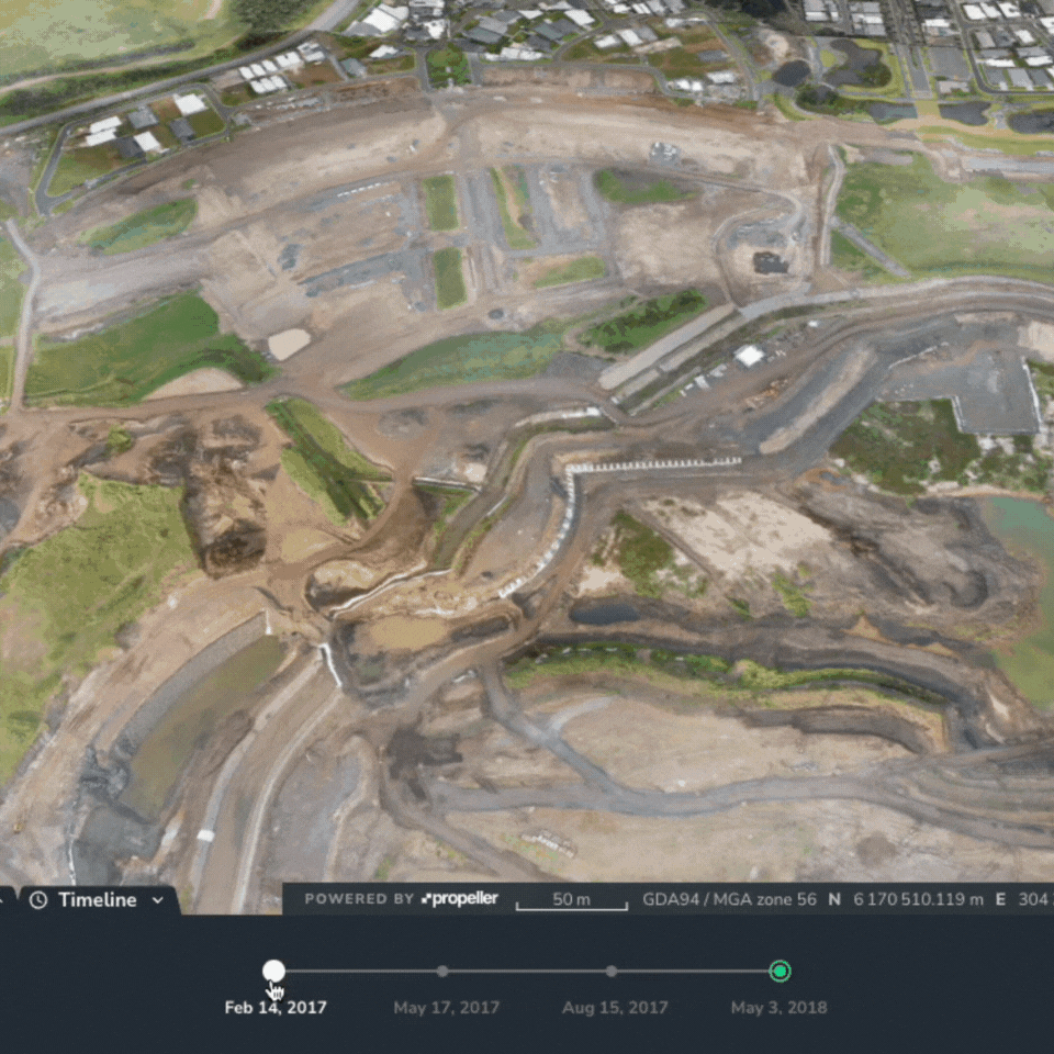
Propeller’s Timeline tool presents proof of work with every survey, making it easy to see what the site looked like at different points in the past and what it looks like today. With clear documentation, it’s easy to prove what was done and when, helping resolve or even prevent disputes with subcontractors and clients.
Export survey data into third-party software
Some construction companies need their drone data available for export into CAD or BIM software for further work. Processing engines like Propeller allow the export of dense point clouds, high-resolution imagery, and 3D elevation models, which can be used in a wide range of software applications.
Simplify reporting
Regular drone surveys help deliver up-to-date information to project stakeholders and contractors by providing a bird’s-eye view that simply isn’t available from the ground. And processing your data with a cloud-based platform reduces the time and expense associated with on-site visits.
With Propeller, processing and generating shareable reports is as easy as dragging and dropping. PDF and CSV reports can be shared with internal or external stakeholders in seconds.


