
Cross Section Survey in a Matter of Minutes Using Drone Data
With the power of drone-captured data and the Propeller Platform, surveying cross sections becomes as…
Peab is a leading Nordic construction and civil engineering company with about 16,000 employees across Scandinavia. Jonas Thim, is the site manager at Rådasand, a quarry run by Peab subsidiary Swerock AB. He’s in charge of making sure production on-site runs smoothly and also plays a role in finances and sales at the company.
Rådasand is a sand and gravel quarry that primarily produces special sand aggregates for use in the automotive industry, water treatment, and thermal power stations. While the amount of material they have on stock varies from month to month, Thim estimates they will have about 100,000 tons in their stockyard come December.
As with any quarry, stockpile management is crucial to optimizing profits. Thim needs to know how much sand and gravel his team has extracted, processed, and moved off site per week, in addition to maintaining an up-to-date inventory of each and every stockpile. Having this information makes it possible for Rådasand to get paid for all their work in a timely fashion, plan future work, and optimize their processes based on material movement patterns.
Unfortunately, getting accurate volumes of each stockpile was a long, tedious, dangerous process using a base and rover.
“We used a GPS stick to shoot some geo-located points, and then we measured the stockpiles manually with measuring tape to estimate the volume,” says Thim. “Measuring a pile manually is time consuming and therefore we didn’t do it that often.”
Because of the obstacles they faced, Rådasand often chose not to even attempt these measurements, instead waiting for an annual drone survey from a third party to supply them with a single, contextless snapshot of their site that day. During those long stretches between surveys, Rådasand’s team resorted to guesswork.
“We just went out to the quarry, looked around, and estimated how much material there was. Then we’d plan where to extract next, based on this very dubious data,” says Thim.
In addition, mine planning was difficult without accurate, actionable visualizations of the quarry. Instead, Thim had to resort to 2D surveys that only depicted contour lines. This made everything from pit planning to developing haul roads a less-than-exact science that caused project delays.
Tired of waiting for their annual drone survey for truly accurate measurements and site-wide visualizations. Thim convinced management to get their own drone that they could fly any time they wanted, and to start processing their data into interactive, measurable site models with Propeller.
Peab’s long-standing relationship with SITECH Sweden made the journey to drones not only attainable, but an effortless addition to their existing workflows. According to Kristoffer Gustafson, Business Area Manager at SITECH, “Peab’s aggregates division was an early adopter of drone surveys and they used products that are easily scaled to grow their pilot team from just a few pilots to ~70 pilots in the first three years.”
Now, instead of spending all day walking across stockpiles to capture potentially shoddy measurements, he’s standing by and flying above them in a fraction of the time and getting accurate volumes every time he surveys.
With more frequent surveys at his disposal, Thim is able to track material movement more closely and make his billing statements more exact, reducing the potential for disputes.
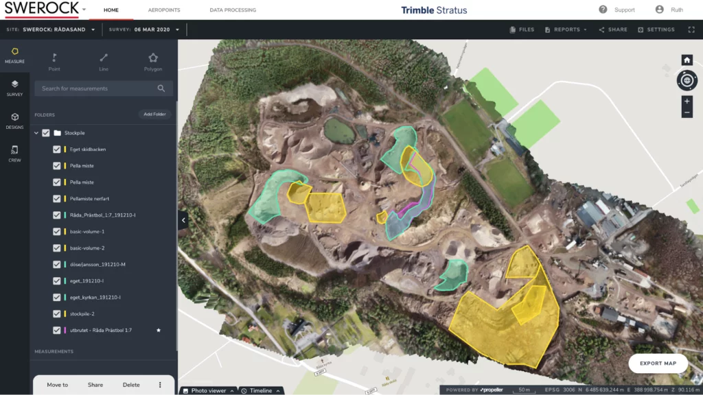
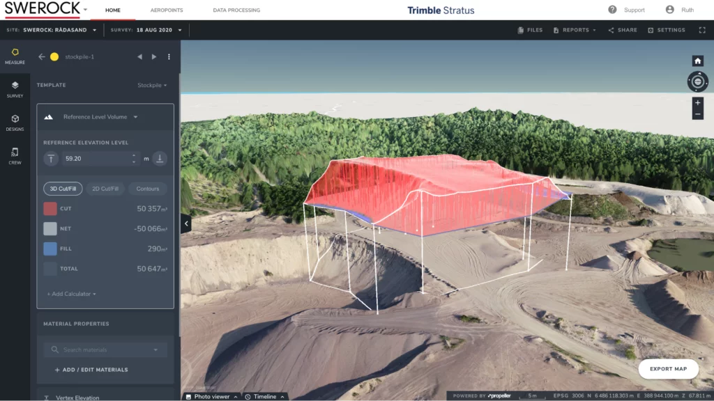
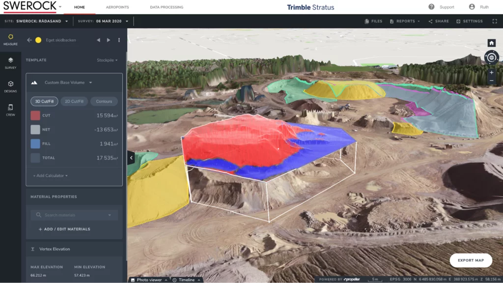
Thim says the feature he gets the most use out of in the Propeller Platform is the polygon tool, which allows him to draw a border around any stockpile and instantly calculate its volume. He can then compare those stockpile volumes in the platform by doing a cut/fill with the previous survey.
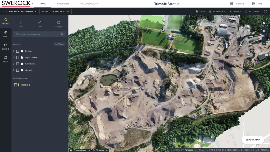
On top of the accurate inventory tracking, the clear, visual nature of his 3D site models has provided Thim and his team with a bird’s eye view of the quarry they can assess from the office.
No more walking to the edge of the quarry, looking around, and guesstimating what needs to be done.
Once he locked down a stockpile management workflow, Thim was free to use the Propeller Platform’s measurement tools to do more in-depth planning. Using the road slope tool, he was able to guarantee his haul road grades were efficiently level. He is also able to import design files when refilling parts of the quarry to help track how much work is left to do until they meet their planned surface.
“I can easily check what it looks like in the quarry,” says Thim. “I can see how much left there is to mine, and during an inventory, I can easily check the stockpiles that are in the area. I can also see how close we are to the property boundaries and balance the extraction of sand accordingly.”
“We have streamlined the measurement process for stockpiles,” says Thim. “Before, the calculations were made in another software. This process was both costly and time consuming. We now scan several times a year and measure directly in Propeller.”
Thim has made sure he’s not the only person directly benefiting from this new vein of data, either. He shares access to the platform with two on-site supervisors, and together they use the site visualizations to plan everything from stockpile placement to planning their next extraction.
And with the ability to easily customize and share an inventory reports, he’s helped to break down communication silos between the quarry and the office, and guarantee accurate statements go out faster. From the office to the quarry itself, Rådasand and Peab have found a way to leverage their drone data to optimize nearly every corner of their business.
Learn more about Propeller’s products, pricing, and how to get started on your site.

