
Of the elements that make up a coordinate reference system (CRS), none are more fundamental than datums. In fact, the term “datum” is often used interchangeably with “geographic coordinate system” (or a type of CRS used for specifying the location of a point on the earth).
But a datum is only one component of a geographic coordinate system—albeit an indispensable one. Because understanding the function of datums is crucial to getting the bigger picture of CRSs, we created this quick primer.

Read on for a quick explanation of horizontal and vertical datums, how they’re used in surveying, and how they’ve evolved over the years. And for a deeper dive into topics related to CRSs and geodesy, you can download our ebook on the subject:

Ellipsoids and geoids
To understand the purpose horizontal and vertical datums serve, we must first discuss two related concepts: ellipsoids and geoids. (You can check out a more thorough explanation of these topics here, but in short:
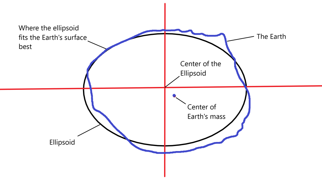
A reference ellipsoid is an approximated, more uniform model of the earth. Like the earth, it’s spherical, but not perfectly so. Unlike the earth, it has a smooth, uninterrupted surface.
Ellipsoids are defined by their geometric parameters, which include a semimajor axis (the radius of its equator) and semiminor axis (distance from its center to either pole). Geodests and surveyors use ellipsoids to assign points angular coordinates, or degrees of longitude and latitude.
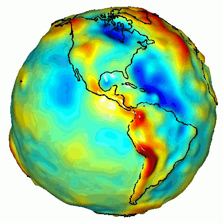
A geoid is a more dynamic model of the earth that accounts for undulations in the planet’s surface. These bumps and dips on the earth’s surface are a result of the planet’s irregular density, which causes gravity to be stronger in some places than others.
Horizontal datums: finding your place in the world
So, ellipsoids and geoids define the size and shape of the earth, to varying degrees of accuracy. But that only gets us halfway to our end goal. To be useful, we also need to know which specific model to use and where to place them in space.
That’s where datums come in. Horizontal datums take an ellipsoid and assign its center a point of origin relative to the center of the earth. Once the ellipsoid is “pinned” to the earth, we can use the horizontal datum to start assigning angular units of longitude and latitude to different points on the earth’s surface. When comparing survey datasets, they need to be referenced through the same datums. Otherwise, the same points in the real world will be assigned different points on your map, and your measurements will be off.
As we just established, the Earth’s surface is not uniform. Knowing this, when surveying, you ideally want to use the datum whose ellipsoidal model best fits your area. In other words, you want a local datum.
For instance, in the United States, surveyors use the North American Datum 1983 (NAD 83), which is based on the Geodetic Reference System 1980 (GRS 80) ellipsoid. If you were to use NAD 83 anywhere outside North America, your measurements would be off.
The journey to NAD 83—and beyond
To get to the NAD 83, geodesists and surveyors first had to establish the NAD 27, which took decades of triangulating the relationships between tens of thousands of survey monuments all around the country. The NAD 27 datum used the Clarke Ellipsoid of 1866 as its basis.
Unlike today’s ellipsoids, which use their geometric center as the origin for all coordinates, the Clarke Ellipsoid used a point in Meade’s Ranch, Kansas, which was approximated to be in the center of the contiguous United States.
Over the years, more and more stations were benchmarked. The NAD 83 datum expanded on the NAD 27 to over 250,000 stations. It also used terrestrial and Doppler satellite data to correct some of the distortions in distance in the NAD 27. Over the past 37 years, the NAD 83 has been updated several times thanks to advances in GPS and geodesy.
With the advent of GPS, geodesists were able to develop a highly accurate worldwide ellipsoid model and corresponding datum called the WGS 84 that is still used for global mapping purposes today. The WGS 84 is an example of a geocentric datum. The center of the WGS 84 ellipsoid is generally considered to be about 2cm off the center of the earth’s mass.
All GPS data is referenced through the WGS 84. And while horizontal measurements between the WGS 84 and NAD 83 are on average only one meter, that’s a big enough difference in some disciplines—digging a trench on a construction site or creating a haul road on a mining site, for instance—to make a datum transformation from GPS collected coordinates to your local datum necessary.

Vertical datums: How low (or high) can you go?
While horizontal datums pinpoint a location on the earth’s surface, a vertical datum gets you elevation data. Vertical datums use the surface of a geoid model to establish a zero-point of elevation. When using a vertical datum, you can describe a point as being x-feet above or below the “Mean Sea Level (MSL).”
The MSL actually represents an “equipotential surface,” or a surface in which all points experience the same force of gravity. Another way to think about it is that it’s how the ocean would cover the earth’s topography if tides, wind, and some other factors that restrict its movements didn’t exist. The only factor that affects the MSL’s shape is the earth’s gravitational field.
Like horizontal datums, there are localized vertical datums. In the U.S., we use the North American Vertical Datum of 1988 (NAVD 88).
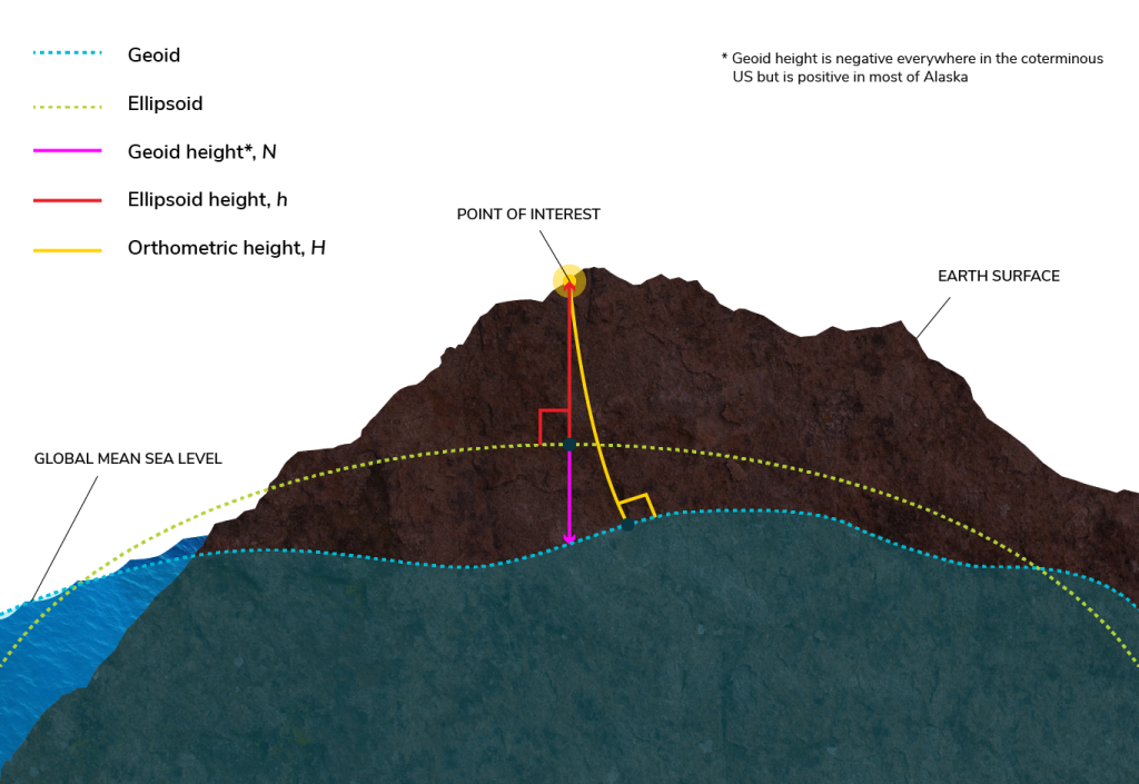
Determining the elevation (or orthometric height) of a point in relation to the vertical datum requires a geoid, an ellipsoid, and a simple equation. You just take the ellipsoid height (the distance between your reference ellipsoid and the point on the Earth’s surface you’re trying to measure) and add it to the geoid height (the offset value between the geoid and the ellipsoid models).
Out of the tides and into the heights
As with the evolution of horizontal datums in North America, we wouldn’t have today’s more accurate NAVD 88 with the National Geodetic Vertical Datum of 1929 (NGVD 29)
Formally called the Sea Level Datum, the NGVD 29 was established using two dozen tidal gauge stations along both coasts of North America. These stations measured tidal changes continuously for twenty years in order to establish an MSL for the entire country. A network of level lines between these gauges was used to establish the datum.
In the 1970s, the National Geodetic Survey changed the datum’s name to the NGVD when it became obvious that the sea is not actually level (due to, as we’ve already discussed, factors like wind, currents, salinity, etc.)
And then in the 1980s, the NGS decided to completely overhaul the nationwide datum. Using a system of “geodetic leveling” and satellite readings, the North American Vertical Datum of 1988 was established.
Differences between the NGVD 29 and NAVD 88 range from half a foot to a yard depending where you are in North America. Still, some organizations (like FEMA) that use elevation data didn’t adopt the NAVD 88 for a decade or more, mostly because they had over 60 years of historical survey data that would need to be transformed in order to correspond to surveys done with the new datum.


