New: Point Cloud Uploads in Propeller

Read Time: < 1 min
Quick links

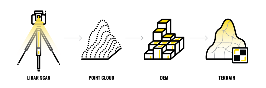
    After being introduced for commercial use 20 years ago, LiDAR has proven to be a powerful tool in the surveying toolbox. As hardware costs continue to go down, we’re seeing more and more worksites using LiDAR as a part of their surveying workflows. That’s why we’re excited to announce the launch of our new easy Point Cloud Upload feature in Propeller.

    The release of this new feature means our customers can now:

    • Drag and drop LAS/LAZ files from any source into Propeller for seamless integration
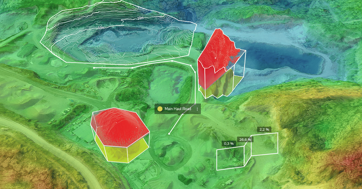
    • View a point cloud data as a 3D terrain that’s ready to measure and track using Propeller’s measurement tools and calculators
    • Easily share point cloud data as a 3D terrain with anyone on site—no additional licenses or software required
    • Store point clouds in one place for easy collaboration and management

    View LiDAR point cloud data 3D terrain

    When you add LiDAR data to your site models, you can now analyze the point cloud with all your favorite measurement tools and calculators in the Propeller Platform. Our new Point Cloud Upload feature empowers you to better track, map, and measure your site using even more survey data. 

    Quick links

      Related articles

      Better Blast Planning, Monitoring and Quarry Reporting Using Drone Data

      Making decisions with the most up-to-date and reliable information is critical for any site manager,…

      Six smart ways to use drones in mines and quarries

      The use of drones in mines and quarries is common, but these sites are highly…

      Cross Section Survey in a Matter of Minutes Using Drone Data

      With the power of drone-captured data and the Propeller Platform, surveying cross sections becomes as…

      Ready to learn how Propeller can power up your worksite?

      We’re happy to show you how Propeller can power your worksite, and boost productivity.

      Related articles

      Drone pilot in hi-vis flying a drone next to a crane, with an AeroPoint on the floor.

      Things To Know About Ground Control in Drone Surveying

      Ground control is the go-to option for turning drone data into highly accurate, survey-grade models.…
      DJI M4E flying in the sky

      Propeller’s Drone Guide: DJI Solutions for Commercial Operations

      At Propeller we love testing new drone hardware and we are processing hundreds of drone…

      Telecom Tower Inspection using DJI Phantom 4 Pro: Step-by-Step Guide

      A few weeks ago a new DJI Phantom 4 Pro was delivered to our office.…