Did you know there are several types of drone surveying? Drones are versatile and can be outfitted with very different kinds of technology.
If your work requires a bare earth survey, you’ve probably heard of two technologies known for their ability to capture detailed survey data from the air: LiDAR and photogrammetry. Both methods have revolutionized how professionals across industries gather, map, and analyze geospatial data.
So when should you choose one approach over the other? Can you use both together, or is drone surveying a zero-sum game, with one approach emerging triumphant over the other?
Spoiler alert: LiDAR and photogrammetry are both valuable tools on today’s worksite. Each has its own time to shine, depending on your terrain and stage of work.
In this post, we’ll demystify the differences between LiDAR and photogrammetry and leave you with a clear understanding of which approach will work best for your worksite.
What is LiDAR?
LiDAR stands for Light Detection and Ranging. Unlike traditional drone surveying, lidar mapping doesn’t rely on what a camera can “see.” Instead, lidar uses laser pulses aimed at topographic features, measuring the reflected light pulses with a sensor to extrapolate data about distances. These laser light pulses can effectively “cut” through heavy vegetation to extract bare earth conditions underneath.
With a bit of trigonometry, you can calculate distances using these millions of reflection points and reconstruct a point-based model of terrain in what’s called a point cloud.LiDAR is often compared to sonar or radar, which use sound and radio waves to map surfaces and detect objects. In most cases, LiDAR uses infrared light. LiDAR sensors can be mounted on planes, tripods, automobiles, and—of course—drones. The technology is sometimes called 3D laser scanning, since it’s ultimately used to generate a three-dimensional point cloud model.
LiDAR vs photogrammetry: what’s the difference?
LiDAR is an example of “active” data collection. You’re taking a direct measurement by physically hitting a feature with light and measuring the reflection to gather distance data.
Drone photogrammetry, on the other hand, is an example of “passive” data collection. Photogrammetry uses images captured by a drone-mounted camera to reconstruct the terrain in an accurate 3D model using image overlap and sufficient ground control.
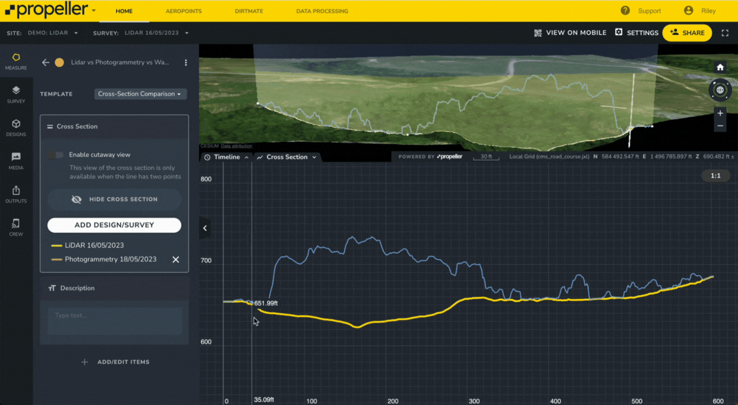
The key difference between LiDAR and photogrammetry is how the data is captured. As we discussed above, LiDAR can penetrate through canopy cover and thicker vegetation to extract details about the bare ground underneath. Because photogrammetry can only produce results from what the camera can see, it can miss details below vegetation like thick grasses, a grove of trees, or a heavy thicket. A topographic survey using photogrammetry on a vegetated site will often miss the details below the surface of that vegetation.
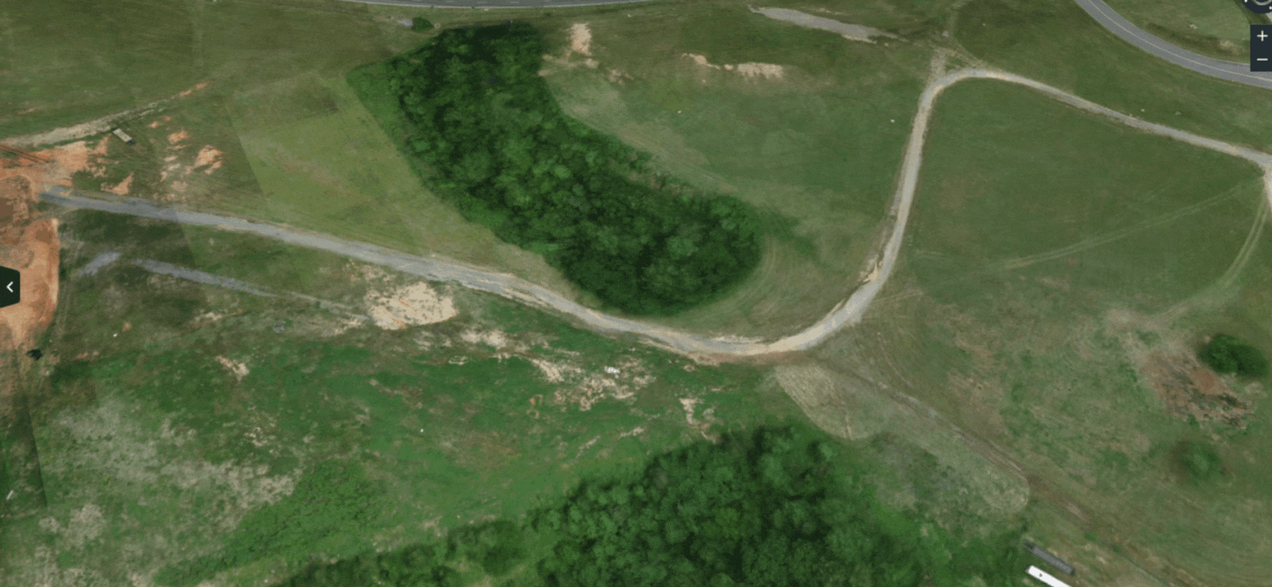
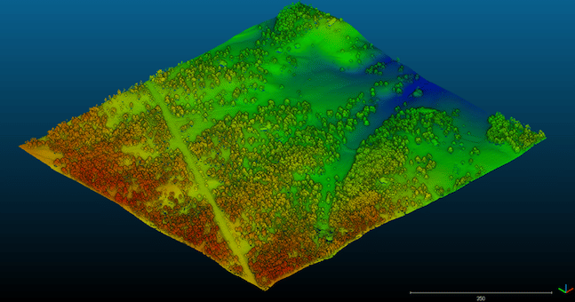
Another difference is the survey output. Where LiDAR yields a point cloud-like image (right half of the image above), photogrammetry uses photos of the site alongside point cloud data to render a fully 3D visual model of the visible terrain (model on the left).
When to use LiDAR vs photogrammetry
As with all technology, LiDAR and photogrammetry each have use cases that they are especially well-suited for.

LiDAR is best suited for:
- Surveying uncleared land with dense vegetation
- High vertical accuracy on vegetated land
- Flying low and slow
- Verifying existing ground conditions before starting site work

Photogrammetry is best suited for:
- Surveying a cleared site with sparse vegetation
- Creating a photorealistic 3D model
- Fast flights at a higher altitude
Which type of drone surveying is more accurate?
Photogrammetry and LiDAR are equally accurate—assuming that you’re using them in the right way. As we’ve already explored, the accuracy of photogrammetric surveying is compromised if you’re capturing images through dense vegetation. Even LiDAR requires some space between leaves for laser pulses to reach the ground, so accuracy will decline above ~90% vegetation on a site.
Also, not all drone photogrammetry is created equal. The quality of your data is only as good as the quality of your input and the reliability of your workflow. RTK workflows will have lower consistent accuracy, as will workflows without sufficient ground control. Smart surveying solutions like Propeller PPK, on the other hand, yield an accuracy of 1/10ft.
Check out our whitepaper for more information on how we get this level of accuracy. →
Survey accuracy is also affected by the drone’s movement with both photogrammetry and LiDAR. So, no matter which technology you choose, you’ll still require data correction to ensure high accuracy.
What is the cost of LiDAR vs photogrammetry?
Costs for LiDAR systems have dropped over the last few years, making the decision to purchase this laser-based technology less risky. While some systems can still be in the six-figure range, those are unique case scenarios requiring advanced equipment.
For the earthmoving industries, most situations will require entry-level or mid-tier drones with LiDAR capability. These drones are fitted with a LiDAR sensor compatible with their existing hardware.
Using the Propeller-recommended DJI M300 or M350 drone, you can easily attach the Zenmuse L1 or L2 sensor for an affordable and accessible LiDAR mapping option.
Is LiDAR photogrammetry a thing?
Well . . . yes and no. While there’s no such discipline as “LiDAR photogrammetry,” it is possible to collect both LiDAR and photogrammetric data in a single flight.
The Zenmuse L1 and L2 sensors, which are compatible with the DJI M300 or M350 drones, allow you to capture photos during a LiDAR mission. The software used to process the LiDAR data typically uses these photos to colorize the point cloud and render it in a more photorealistic way. Alternatively, Propeller produces an orthophoto based on the colorized point cloud.
Replace guesswork with great work
However you choose to survey your site, Propeller is here to support you at every step with our smart surveying workflows. Our GIS experts process both LiDAR and photogrammetry data, so you can leave the data processing to us after your drone has landed. We’ll create your 3D map and deliver the data you need for maximum accuracy with minimum hassle.


