What are smart surveys? Everything you need to know

In the ever-shifting terrain of construction technology, surveying and Geographic Information Systems (GIS) stand out for their versatility and indisputable value across the industry. Historically, the two have been approached as entirely separate tools. Where surveying has been all about data accuracy, GIS has been focused on data accessibility. 

But the rise of 3D mapping has forged a path for the emergence of smart surveys, a meeting ground where surveying and GIS can join forces. As these fields align, they are reshaping the topography of modern sitework. No longer are we limited to mapping or analyzing; instead, we’re combining precision surveying with spatial intelligence to craft multilayered maps that are as savvy as they are essential.

In this post, we’ll bypass the jargon to uncover how smart surveys are integrating the best of each approach to build a more interconnected and intelligent future for the projects that shape our world.

What is GIS?

GIS is a framework for gathering, managing, and analyzing geospatial data.

Parallel lines: A brief history of GIS and surveying

The definition of GIS may sound a bit vague, but don’t get too hung up on it. GIS is all around us—think of the information you can glean from Google Maps, like restaurant reviews or your visit history, and images on your phone that are searchable by location. GIS ties information to a specific place, allowing us to use that data in new and compelling ways.  

In general, GIS tends to be:

  • Highly flexible and configurable
  • Generally biased toward large areas like cities and populous countries
  • Run in global CRS (vs. local)
  • Easily available in the field through mobile apps
  • Not survey grade in terms of accuracy
  • It is more about the things on the map than the map itself
  • 2D vs. 3D

Surveying, on the other hand, arose from an entirely different background. Surveying has been used for centuries to measure physical features and ground terrain precisely, capturing critical data about distances, angles, and elevations. In surveying, accuracy is essential. Specialized instruments capture location data that’s accurate to the centimeter, even at scale. 

In contrast to GIS, surveys have historically been:

  • Hyper-local
  • Accurate over user-friendly
  • Best accessed on desktop using robust software
  • Highly technical and difficult to configure
  • More about the map itself than utility

How 3D maps brought these two worlds closer

3D mapping technology has revolutionized both surveying and GIS, making it possible to visualize geospatial data in entirely new ways. It has also opened the door to a third option: technology that blends the two disciplines into one. 


As surveyors started using drones to capture terrain measurements in three dimensions with increasing precision and ease, GIS professionals have found a treasure trove of data to feed into systems that were eagerly awaiting a jump from flat maps to multi-dimensional models. Integrating detailed feature data with the usability and analytics power of GIS has propelled a leap forward in the toolkit that helps contractors, surveyors, project managers, and onsite workers make better decisions faster.

By presenting survey data in 3D maps that reflect our reality, we can have our cake and eat it, too—digital models that faithfully represent accurate measurements and render them easy to integrate with other data, accessible from anywhere. 

“No one understands measurement, datums, and coordinate systems like professional surveyors. Similarly, the power of the GIS database for data management, collation of spatially related information, querying, analysis, and presentation of spatial products is the bastion of the GIS professional. What can we learn from each other?”  

—Craig Roberts, School of Surveying and Spatial Information Systems, University of NSW

Download our Smart Survey Playbook.

By the end of this playbook, you’ll know how smart surveys empower you and your team to answer how much work is done, how fast it’s progressing, whether or not you’re matching the plan, and if you’re going to make money on a job

Smart surveys: The best of both worlds

Advancing technology has blurred the line between surveying and GIS, creating a new discipline that’s well-placed to address the complex spatial challenges of modern earthwork: Smart surveys.

Smart surveys combine the best of survey technology and GIS to create a consolidated solution that makes survey data simpler, faster, and more intuitive.

Smart surveys merge the accuracy of surveying with the usability of GIS to build an interactive reality that is universally understood. Think surveys, but easy to understand. Think reality capture, but accurate. 

While realistic imagery and accessible media matter, construction professionals know that even the most detailed map is valueless if the accuracy is off. And when optimizing efficiency is everything, they want the power of accurate measurements and sharable data on a single platform that’s accessible to everyone, from clients to field workers.

Best of GIS:
  • Web-based
  • Mobile-friendly
  • User-friendly + easy
  • Geospatial management
  • Used to update stakeholders
Best of surveying:
  • 3D
  • Local CRS
  • Centimeter-level accuracy
  • Used to track progress and get paid

The best of both worlds → Smart surveys.

Investing in intelligence: The case for smart surveys

Smart surveys take the precision of surveying and incorporate the ability to use that geospatial data in increasingly practical ways, allowing you to map, measure, and manage your worksite from a single platform. 

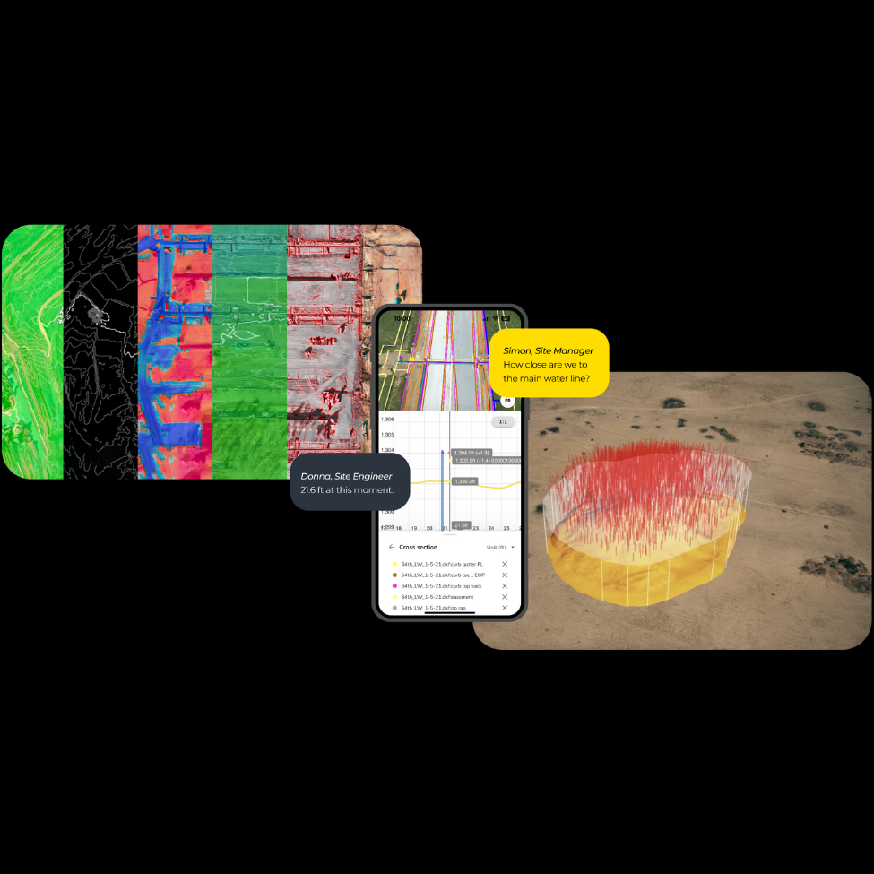
On the modern worksite, survey and GIS shouldn’t be separate worlds. Smart surveys deliver both accuracy and functionality from a single platform, making surveying:

  • Easy + Scalable: Enjoy simple survey data workflows, no matter the size of your business
  • Accurate: Simply upload your data for expert processing and verified survey-grade results.
  • Integrated: An end-to-end solution that works well with your existing systems.
  • Insightful: Accessible data that drives decision-making from any device.
  • Supported: Outsourced processing, analysis, and advice.
  • One-Stop Shop: Map, measure, and manage from a single platform.

Smart surveys represent a shared future in which surveying and GIS continue to converge, serving the needs of everyone who touches earthwork technology without sacrificing accuracy or analysis. 

Welcome to the future of each discipline, brought together in one glorious platform.

Ready to take the first step toward making your surveys smarter? Download our Smart Survey Playbook.

Share

We’re happy to show you how Propeller can power your worksite, and boost productivity. Simply request a demo now.

Subscribe to our newsletter

Get the latest from Propeller, including industry news, customer stories, webinars, videos, and more.

You may unsubscribe from these communications at any time. For information on how to unsubscribe, as well as our privacy practices and commitment to protecting your privacy, please review our Privacy Policy.