Site Drainage Series (3/6)
In Part 1 and Part 2 of our Site Drainage Series, we looked at how to model storms before they arrive, and how to understand where water will drain on-site. But once rain hits the ground, crews have a more urgent question in mind:
Where is water actually moving, and where will it first start to pool?
Surface runoff is insidious, starting slowly at first with water creeping toward a boundary or skirting past controls that looked fine on paper. Left unchecked, these small movements can turn into major compliance issues and cleanup costs, not to mention valuable work time lost.
Propeller’s surface runoff workflow is built to catch those problems early, before they spread.
The challenge: Why traditional tools can miss runoff problems
Most survey and hydrology workflows are siloed. The survey workflows capture elevation and current surface data, but they don’t tell you how water behaves across that surface. Hydrology models do—but only if you take the time to manually port that data across.
Which leaves most crews with a big blind spot, where they can’t see:
- Where water will flow down a slope
- Where it will slow, spread, or pool
- Which depressions will trap runoff after rain
- How grading changes have altered surface runoff since last week
The downstream impact of surface runoff
For compliance teams, this blind spot is risky. Runoff doesn’t need to be catastrophic in scale to trigger a violation—it just needs to reach the wrong place.
Surface runoff is one of the most common causes of:
- Sediment that leaves the site boundary
- Overtopped inlet protection
- Uncontrolled discharge citations
- Emergency cleanup before inspections
In civil construction, a small runoff bypass can turn into a SWPPP violation. In waste management, mining, and aggregates, it can mean leachate or tailings overrun moving where it shouldn’t, posing a serious threat to public health and a significant fine in the process.
The key is to know where runoff will happen so you redirect it before it becomes a problem.
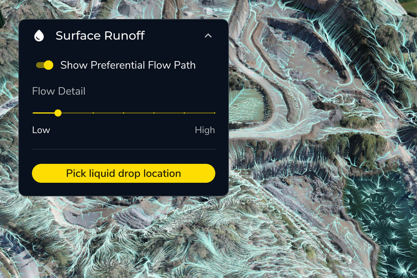
The fix: See surface runoff data in your daily mapping tool
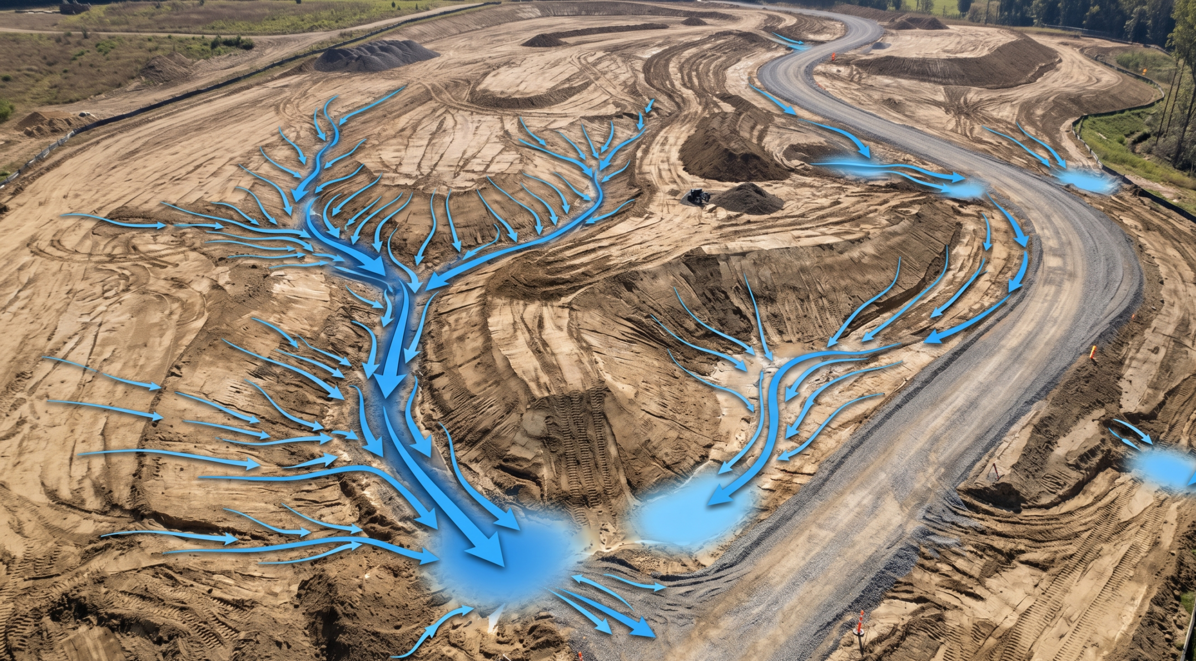
Surface Runoff feature summary
- Problem it solves: Teams can’t easily see how water flows across the site surface.
- What it does: Shows downhill flow direction and accumulation areas where runoff is likely to concentrate.
- How it helps: Shows where water will travel and potentially collect so teams can reinforce controls.
Note: More advanced hydraulic models will account for soil types, infiltration rates, and absorption, but Propeller’s hydrology toolkit doesn’t get that complex. Instead, we’re focused on providing quick, easy-to-access insights within the site map your team is already using.
4 site drainage questions Propeller helps answer:
- Where will water start moving first?
- Where will it get stuck?
- What will it touch on the way (e.g., roads, benches, controls, site boundaries)?
- What can we do to prevent downtime?
How Propeller’s surface runoff tool works in practice
On a roadway expansion project, a quick surface runoff analysis in Propeller reveals shallow pooling forming across a temporary access road, just upslope from a perimeter swale. Design plans didn’t flag it, and it’s not obvious from the topo or a visual scan, but the runoff map shows flow converging toward that edge.
With rain in the forecast, the crew can add a minor regrade and extend inlet protection, so the site passes inspection and has no runoff violations after the weather clears.
At a mine or quarry, runoff analysis might show water flow cutting across a haul road after recent bench grading. The water won’t flood the road, but it will carry sediment toward a discharge point tied to permit limits. By adding a small berm, the site can avoid sediment migration that would have required reporting and cleanup.
Active landfills are another great use case. Surface runoff mapping can expose micro-pools that will form on the cap surface after routine work. Left alone, those pools could accelerate leachate generation. With quick data to guide them, teams can improve surface drainage and turn a potential compliance issue into routine maintenance.
When small runoff flows become big problems
Surface runoff issues escalate quickly because they compound on each other. Small pools weaken surfaces and extend drying time. Controls that “almost” intercept flow paths fail under sustained volume.
Inspectors see patterns, not isolated incidents, and cleanup costs stack up from repeated minor failures. Preventing runoff on your site surface is one of the most effective ways to reduce environmental risk and operational drag.
How surface runoff works
- Step 1: Upload your survey. Use drone data, LiDAR, or a ground topo—wherever your latest surface data comes from.
- Step 2: Run surface runoff analysis. Propeller calculates downhill flow direction and accumulation zones automatically.
- Step 3: Visualize results. Flow arrows show direction, and shaded areas show where water slows or pools.
- Step 4: Identify risk zones. Adjust grading or controls to reduce or eliminate runoff risk.
The results
A little advance planning as part of a seamless site mapping workflow goes a long way.
- Fewer surprises after storms
- Stronger SWPPP documentation
- Cleaner site boundaries
- Reduced sediment cleanup
- Less reactive work between grading phases
- Safer worksites for crews and equipment


