• Products
  • Solutions
  • Resources
  • Customers
  • English
  • Deutsch
Contact us Log in REQUEST A DEMO
PLATFORM

Propeller A single, cloud-powered map that brings your plans, data, and team together
Map
Measure + manage

HARDWARE

DirtMate Real-time machine guidance for precise, efficient earthmoving
AeroPoints High-accuracy ground points for faster, reliable surveys
Hardware integrations Connect Propeller with your existing tools seamlessly

PROCESSING

Propeller PPK Survey-grade positioning for trusted drone measurements
Photogrammetry Turn aerial images into detailed 3D maps
LiDAR Capture precise, high-density data for any terrain

PLATFORM

Propeller A single, cloud-powered map that brings your plans, data, and team together

INDUSTRIES

Construction
Mining
Aggregates
Waste management
Survey + engineering

CAPABILITIES

Site checks + analytics
Volume calculations
Progress tracking
Machine telematics
Field communication + collaboration
Subcontractor management
Machine productivity

CONNECT

Community
Training + support

LEARN

Blog
Knowledge Base

PEOPLE

Careers
About Us

Products
PLATFORM

Propeller A single, cloud-powered map that brings your plans, data, and team together
Map
Measure + manage

HARDWARE

DirtMate Real-time machine guidance for precise, efficient earthmoving
AeroPoints High-accuracy ground points for faster, reliable surveys
Hardware integrations Connect Propeller with your existing tools seamlessly

PROCESSING

Propeller PPK Survey-grade positioning for trusted drone measurements
Photogrammetry Turn aerial images into detailed 3D maps
LiDAR Capture precise, high-density data for any terrain

Solutions
PLATFORM

Propeller A single, cloud-powered map that brings your plans, data, and team together

INDUSTRIES

Construction
Mining
Aggregates
Waste management
Survey + engineering

CAPABILITIES

Site checks + analytics
Volume calculations
Progress tracking
Machine telematics
Field communication + collaboration
Subcontractor management
Machine productivity

Resources
CONNECT

Community
Training + support

LEARN

Blog
Knowledge Base

PEOPLE

Careers
About Us

Customers Contact us
REQUEST A DEMO Log in

3cm Landfill Liner Breach Detected with Accurate As-Builts, Drone Data Visualization

Track and Share Safety Hazards with 3D Drone-Powered Site Maps

How Up-to-Date Construction Data is Improving Worksite Operations

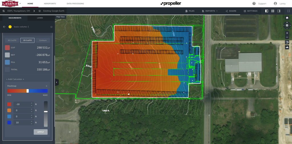
Legend Engineering Uses Propeller to Save Crew Time, Communicate with Clients as Part of Komatsu Smart Construction Initiative

Women in Mining Q&A: Orica’s Cara Rosen

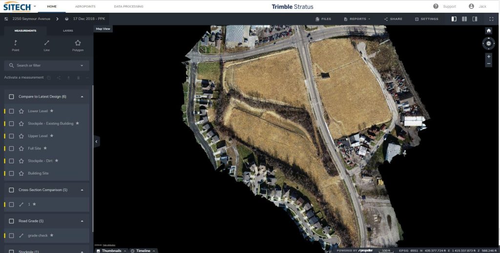
Ohio-based Sunesis Construction Uses Trimble Stratus Powered by Propeller for Tracking Earthwork and More

10 Ways Drone Data and Earthwork Software Can Make Your Next Project a Success

Big D Construction Uses Propeller for Faster Oil Pad Building in Texas

Women in Construction Q&A: Alaska DOT’s Brandy Milles

Four Ways to Improve Your 3D Site Surveys with Terrain Cleanups

Previous 1 2 3 4 5 6 … 12 Next
Propeller Aero: Drone Mapping Platform Homepage
English
Deutsch
Propeller SOC 2 Type 1 AICPA Certified

Platform

  • Propeller
  • DirtMate
  • AeroPoints
  • Hardware integrations
  • Propeller PPK
  • Photogrammetry
  • LiDAR

Industries

    • Construction
    • Mining
    • Aggregates
    • Waste Management
    • Survey + Engineering

Capabilities

  • Site checks + analytics
  • Volume calculations
  • Progress tracking
  • Machine telematics
  • Field communication + collaboration
  • Subcontractor management
  • Machine productivity

Learn

  • Blog
  • Training + support
  • Knowledge base

Resources

  • Community
  • Customers
  • Careers
  • About us
  • Propeller store

© 2025 Propeller Aero Terms + Conditions Privacy Policy Platform Security