Accurate drone solutions for real-time stockpile volume calculation

Read Time: 8 mins
Quick links
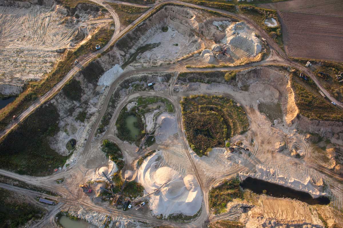
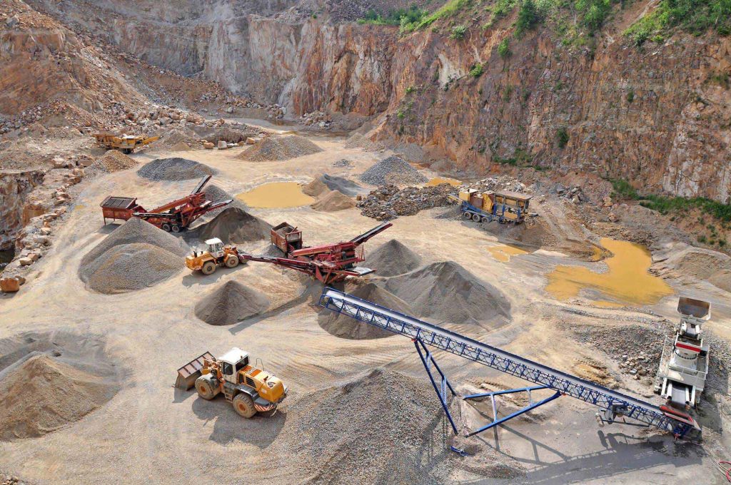
    A drone image looking down at a Quarry site.

    Drone surveys give mine, quarry, and construction teams a faster, safer way to measure stockpile volumes with accuracy to 1/10ft (3cm), replacing manual site traverses with high-precision 3D maps processed in 24 hours. Propeller turns that aerial data into volume calculations, inventory reports, and audit-ready quantity records teams can use for financial forecasting, supply-chain planning, and reconciliation.

    Using drones to calculate stockpile volume measurements makes it easy to compare your current stockpile volumes to previous surveys and track site progress. You can also compare stockpile surveys to a final grade design file to calculate how much material you still need to add or remove.

    With geo-referenced images captured by a drone flying above your worksite, you can use photogrammetry to generate a 3D map of your site with measurements accurate to 1/10ft (3cm). Drone survey visualization platforms like Propeller leverage that accuracy to take a variety of measurements, including stockpile volume calculations.

    Using drones to measure stockpiles is quickly becoming a go-to surveying workflow for earthwork sites around the world.

    Stockpile measurement and reporting guide

    For professionals in the mining and aggregates industries, stockpile inventory management is one of the primary use cases for drone surveying. Construction sites also use drones to survey their sites more quickly. The 3D maps generated from those flights capture actionable data, including stockpile volume calculations.

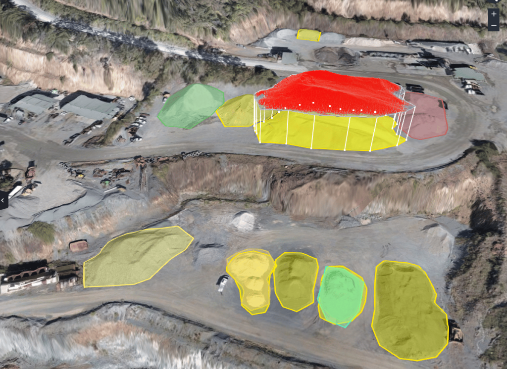
    Stockpile volume measurement in a quarry

    By flying a drone to measure stockpile volumes instead of sending someone out to traverse a dangerous site, site management can track their inventories and site progress in a faster, safer, more reliable way.

    Let’s break down how drones and photogrammetry help worksites improve stockpile measurement workflows and streamline site analysis.

    Want to see the full inventory management workflow, including monthly audit reports and financial reconciliation?

    Explore how Propeller handles the complete stockpile inventory management workflow →

    Why accurate stockpile volume measurements matter

    Mine and quarry managers spend much of their time answering questions, or struggling to answer them, about quantities. How much is sitting in the stockyard right now? How much is going in the crusher or mill? How do you calculate stockpile volume accurately? What do you still need to extract? How much have you moved since last Thursday? What was its true value, and did you sell it for the right price?

    When you have accurate site surveys at your fingertips and full oversight of your stockpile inventory, finding the answers gets a whole lot simpler. Drone surveying workflows provide dependable, high-precision stockpile measurements. And you can measure progress as frequently as you want to fly. That influx of inventory data helps teams tighten up worksite operations, covering everything from financial forecasting and supply-chain management to accurate reconciliation.

    How to calculate stockpile volume with a drone and Propeller
    1. Prepare more accurate financial forecasts

    Using drones to measure stockpiles is cheaper and easier than traditional surveying equipment. It’s also far more accurate than eyeballing stockpile volumes. Drones put the power of frequent surveying in your hands and accurate volume calculation data at your fingertips.

    Reliable inventory numbers every month means drastically fewer write-offs, saving money and improving mine or quarry efficiency. With drone surveying, “fluff factors” in inventory management become a thing of the past. Using photogrammetry combined with smart ground control points (AeroPoints) and supported drone hardware, you can generate site models with an accuracy tolerance of 1/10ft (3cm). That’s good enough for nearly anyone’s stockpile measurement standards.

    2. Tighten up your supply chain

    Knowing what you actually have on site lets you better organize your supply chain. Report on inventory and supply quick asset snapshots, from when you need more stock to how much you still need to extract. If you’re your own supplier, plan when you need to start drilling and blasting based on current volumes. If you use an external supplier, plan purchases further in advance and calculate a more accurate budget.

    3. Reduce costly write-offs

    All quarries need accurate information on stockyard tonnage to fulfill work orders and stay financially solvent. But too often, big write-offs are par for the course. Even when they’re outrageously high, they’ve become an accepted status quo. Drone stockpile measurement gives you high-precision volumes so you can reconcile accounting discrepancies during an audit with real data, not estimates.

    Nevada Gold Mines case study

    Using drones to measure stockpiles: the basics

    First, fly your drone to capture site data

    Before you can take a single volume measurement, you need to capture site data with a drone flight. There are a few ways to do this. “Drone surveying” means using a drone to take aerial photos of your site, combined with GPS data and ground control to provide geographical context.

    There are two major drone surveying workflows: GCP-based drone surveying and PPK drone surveying. (Find out why we recommend a PPK workflow here.) Flying a drone to survey your site is significantly faster, up to 10x faster by some estimates, than traditional ground-based methods. It’s also safer for a drone pilot to stand by and let the drone capture the data instead of walking the site themselves.

    Next, let the photogrammetry software do the work

    Once you’ve got imagery and ground control data, it needs to be processed into your 3D model. For all but the largest operations, keeping a photogrammetrist on staff is cost-prohibitive. Processing the data in-house is also a lengthy manual process that requires specialized software and often a dedicated computer.

    Propeller processes drone data for you with a 24-hour turnaround, so you can focus on other work. And you don’t just get the final model. You get easy access to data outputs: point clouds, digital elevation models, and more, all exportable for use in other GIS and CAD programs.

    New call-to-action

    How to use drones to measure stockpile volumes for quarries or mines

    Once you’ve generated your model, you can analyze your site using drone data visualization software like the Propeller Platform. Measuring the volume of a stockpile in Propeller is as simple as drawing a boundary around it with a few clicks.

    You can quickly make the types of comparisons site managers use to measure progress and keep track of material inventory. The measurement method you use will depend on the information you need.

    Option 1: Measure volume from a reference level. Set the baseline to the desired figure and calculate stockpile volume from that level up.
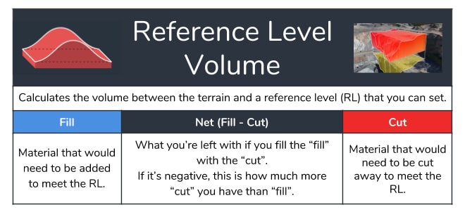
    reference level volume measurement

    Option 2: Measure using a smart volume, and let the platform do the work. For a smart volume, the platform extrapolates where the base of your pile is and calculates a total volume from there.
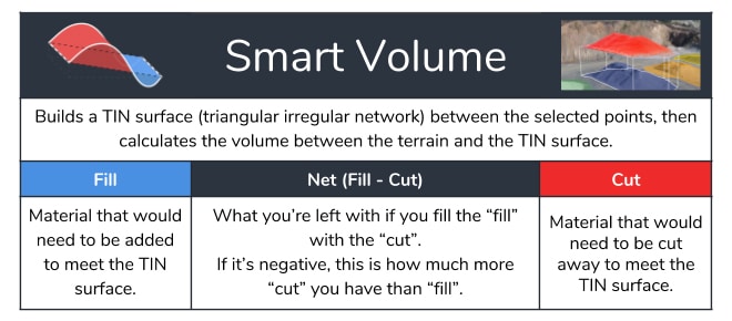
    smart volume for stockpile measurement

    Option 3: Compare volumes between two surfaces. Compare survey to survey to see progress over time. Or compare the current surface to a final grade design you’ve uploaded to Propeller.
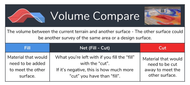
    volume compare measurement
    Using the stockpile volume calculator to determine the value of stockpiles

    Once you have a stockpile volume, you can enter its known material density into our stockpile volume calculator. This tool helps you determine the tonnage and cost of any stockpile using a simple volume calculation.

    For example, let’s say you want to find how much material has been added to or removed from a stockpile since your last drone survey.

    Simply select the Polygon tool and draw a line around the base of the stockpile. In an instant, Propeller takes the thousands of recorded height samples within your digital elevation model and runs the calculation within the boundary of that polygon.
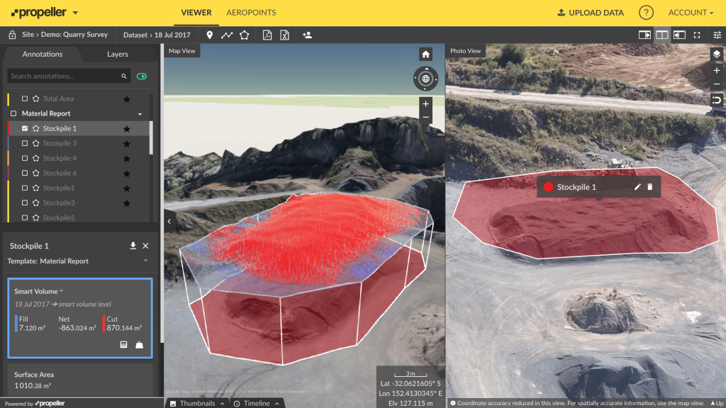
    Stockpile volume measurement using survey data shown on the Propeller platform.

    Next, Propeller compares these height readings to those from your previous survey. Volume changes are expressed as Fills where material has been added, or Cuts where material has been removed.

    The Net value is the difference between the Cut and Fill. When measuring stockpile volumes, the Net figure will be more or less synonymous with the Cut, since you are measuring one mound of land above the base elevation.

    It’s also possible to visualize stockpile changes as a cross-section. Just use Propeller’s Line tool to generate a graph depicting the elevation change for each point on that line.
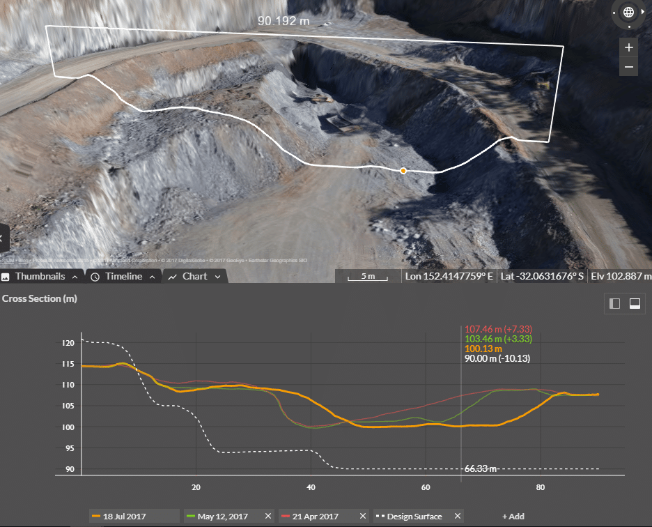
    cross section in a quarry

    The measurement process for pit and stockyard volumes is similar to that of quarries and mines. Having the correct grade blends is essential to success.

    Insufficient input grades are often discovered after the fact, when the final material doesn’t add up to pre-processing records. Use Propeller to monitor stockpiles before something goes wrong, not after.

    We know landfill surveys can be difficult, too. Drone surveying can capture the data you need in hours, not days, without sending anyone to walk over dangerous piles.

    Our complete guide to using drones for aggregates - How to calculate stockpile volume.

    How to report on your stockpile volumes

    Mine and quarry managers consistently rank material moved as one of the most critical metrics for operational efficiency. That comes as no surprise. Keeping track of material inventory at every stage of a project is fundamental to smart decision-making on mine and quarry sites.

    But having that data available to your organization is only useful if it can be shared in a contextual, easy-to-understand format. Financial recordkeepers and auditors, for example, usually need volume and dollar amount, not raw tonnage.

    Propeller’s inventory reporting for stockpiles lets platform users export customized data in either a PDF or a CSV so they can pull it into another accounting or site management program.

    3D blast planning and other drone surveying use cases for quarries and mines

    Using drones to measure stockpiles is not the only application for mines and aggregates sites. Before you can build up your stock, you need to extract it. Making decisions with the most up-to-date information is critical for any site manager, especially when planning and executing blasting work on a mine or quarry site. Keeping site survey and bench level plans updated and accurate can dramatically improve blast results and reduce drilling and blasting costs.

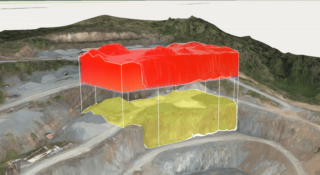
    blast volume measurement

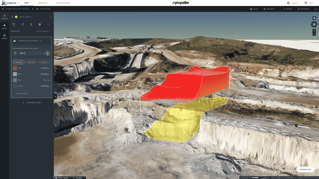
    When planning blast works to fill a specific customer’s order, you can easily identify a volume on the 3D model using the Volume to Reference Level measurement tool. Draw a shape around the blast area, set the bench level to blast to, and the platform handles the calculation from there.

    bench volumes

    These images also provide a useful data source for visual assessment of blast results like muckpile shape, back damage, distribution, and fragmentation. Plan your post-blast logistics using fragment size and location data. You can also measure pile volume and fragment size, add annotations, and share blast reports with stakeholders directly from the platform.

    Using Volume Compare, you can compare the blasted volume against the plan, making it easier to verify whether the right amount of material was extracted. If you have any design or linework, you can overlay it into the model to support accuracy and quality, and confirm you’re not leaving resources in the ground.

    Quick links

      Related articles

      Drone pilot in hi-vis flying a drone next to a crane, with an AeroPoint on the floor.

      Things To Know About Ground Control in Drone Surveying

      Ground control is the go-to option for turning drone data into highly accurate, survey-grade models.…
      DJI M4E flying in the sky

      Propeller’s Drone Guide: DJI Solutions for Commercial Operations

      At Propeller we love testing new drone hardware and we are processing hundreds of drone…

      Telecom Tower Inspection using DJI Phantom 4 Pro: Step-by-Step Guide

      A few weeks ago a new DJI Phantom 4 Pro was delivered to our office.…

      Ready to learn how Propeller can power up your worksite?

      We’re happy to show you how Propeller can power your worksite, and boost productivity.

      Related articles

      Drone pilot in hi-vis flying a drone next to a crane, with an AeroPoint on the floor.

      Things To Know About Ground Control in Drone Surveying

      Ground control is the go-to option for turning drone data into highly accurate, survey-grade models.…
      DJI M4E flying in the sky

      Propeller’s Drone Guide: DJI Solutions for Commercial Operations

      At Propeller we love testing new drone hardware and we are processing hundreds of drone…

      Telecom Tower Inspection using DJI Phantom 4 Pro: Step-by-Step Guide

      A few weeks ago a new DJI Phantom 4 Pro was delivered to our office.…