In the last few years, commercial drones have been changing and modernizing traditional surveying workflows on construction, mining, aggregates, and waste management sites all over the world. They provide accurate site data in significantly less time and at lower cost than traditional options.

But when it comes to actually getting a drone program up and running on your site, there can be a lot unknowns about how to do it right. Before we dive into the particulars, you might be wondering why you’d want to start a drone surveying program on your site in the first place. It’s simple if you follow these five steps:
Step 1: Get your airspace and pilot certification
Step 2: Research restricted airspace
Step 3: Learn how to capture the best data
Step 4: Actually flying your drone on site
Step 5: Invest in software (it’s what makes your data useful)
Drone surveying increases efficiency, lowers surveying costs, and reduces safety risks
When you switch from traditional base-and-rover surveying to drone surveying on site, you are setting yourself and team up to make better, data-driven decisions. The efficiency of drones surveying allows you to shave days or weeks off typical surveying workflows.
And since the drone is doing most of the work, you don’t need to send personnel out to walk a site or access dangerous areas. This alone reduces safety risks and speeds up data gathering.
Further, drones are cheaper and simpler to use than traditional surveying equipment, so you don’t need to spend tens of thousands of dollars on hardware and you don’t need to have special training or education to capture site data. You can do it yourself. You no longer have to wait for infrequent or third-party surveys. You can update your data as often as you want to fly.
With the right processing software and ground control, you can achieve survey-grade accuracy throughout your site.
As you can imagine, the people who benefit from drone operations make up a long list. They include:
- Site managers
- Project managers
- Engineers
- Site supervisors
- Head office personnel
- Surveyors
- Production managers
- Accountants
- Foremen
- Chief estimators
- Superintendents
- Equipment operators
- Safety officers
- Owners and reps
So let’s dive in.
We’ll start with aviation regulations and what red tape you need to go through to get a drone up in the air
Step 1: Get your airspace and pilot certification
A drone is a type of aircraft, albeit tiny. All unmanned autonomous vehicles (UAVs) are regulated by a country’s aviation authority.
The rules differ depending on where you are, but you can expect to have weight restrictions for your craft and some kind of certification or licensing for the pilots when it comes to flying commercially, as opposed to recreationally.
Where your site is located can also influence how, when, and if you fly, depending on the airspace it inhabits.
Additionally, some websites catalogue regulations by country, like Global Drone Regulations Database, or there are apps, like the B4YouFly app for the US that give you information based on your location.
Step 2: Research restricted airspace
Another element you need to be aware of before you begin a drone surveying program is what airspace your site is in.
Airspace is some portion of the sky that’s controlled by a country above its territory. Airspace is divided into six classes. These classes indicate its use and restrictions. For example, the airspace up at 2,500 feet is Class D, and it’s controlled. You couldn’t just fly something in this area without authorization.
While there are many nuances and allowances in controlled airspace, the things you watch out for are as follows:
- If your site is near an airport or helipad
- If your site is near a military base
- If your site is in an urban environment
Should the airspace you’re in be controlled, you’ll need to gain additional permission to fly it. This authorization would usually come from the airport or military. If you’re near one of 500 participating airports, you can get authorization via the LAANC program.
This is a new rollout from the FAA that drastically cuts down on the time spent waiting for authorization to fly drones in controlled airspace. All you need is to enter a few parameters and if you’re operating within Part 107 regulations and fly under a ceiling within a square mile, you can get authorization immediately.
You can obtain LAANC authorization through a number of FAA-partnered companies and apps.
Step 3: Learn how to capture the best data
Getting the best data starts when you’re out on the field. Even small mistakes during your drone flight can have big effects on your final drone survey, no matter what software you’re using.
The main elements that affect data quality are:
- Physical flight (including hardware, height, and speed)
- Image quality, overlap, camera settings
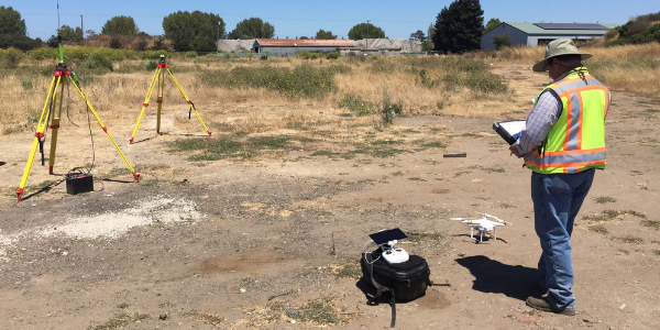
- Ground control setup and sufficient ground sample distance
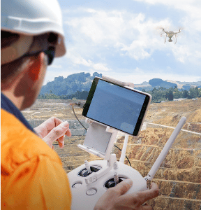
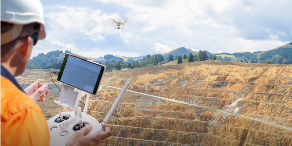
Step 4: Actually flying your drone on site
When it comes to actually walking out on site to launch your drone, the flight itself is mostly automated. Apps like GS Pro take all the complexity out of the actual flying—and it’s free. It takes only a couple of minutes to set up your drone’s flight path on a touchscreen, then simply hit Go. There’s no manual control involved.
We recommend automated flying because steady, consistent flight is crucial to image quality. If you have poor quality images, you’ll get poor quality surveys. It’s as simple as that.
Step 5: Invest in software (it’s what makes your data useful)
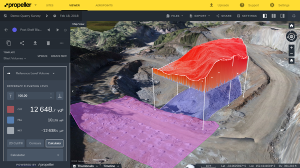
With great mapping and analytics software, you can calculate stockpile volumes in a couple of clicks; check road grades in seconds; monitor environmental zones over time and after big events; track compaction rates and remaining airspace accurately; and so much more.
Investing time and work hours in finding the right software for you needs pays off. Platforms are continually advancing, and while some are optimized for agriculture, others are purpose-built to meet civil contractor and resources industry needs.
A platform like Propeller sits in the latter category. You can track progress and productivity on site, measure quality, and mitigate cost with simple tools anyone can use—all without downloading a single software program.
Data analytics, planning, quality assurance, and progress tracking—those are the places to focus your time, those are the ways that you can make the biggest difference in efficiency and cost mitigation on your site.
So if you’re on a mine, a quarry, a landfill, or a civil construction site, how do you go about picking the right software?


