360 Walkthroughs
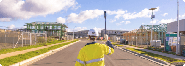
Bring the field into the map
Capture on-the-ground proof and sync it straight into Propeller’s map, so the field and the office can work from the same truth.
Talk to an expert
The problem
The job site moves faster than your next drone flight. And a huge amount of ground-level context never makes it back to the office.
When the context lives in camera rolls and message threads, decisions slow down and things get missed.
The solution
Walk the site without being there
360 Walkthroughs capture a complete visual record you can revisit anytime. Keep teams aligned, verify progress, and answer questions faster without extra site visits. Because it lives in Propeller, walkthroughs sit alongside your surveys, designs, and measurements in the same map.
What you can do with 360 Walkthroughs
Capture the ground-level context drones can’t
Create a complete visual record, review it on the map, and keep teams aligned without another site visit.
01
Capture a complete, ground-level record fast
Record a 360 walkthrough on site with an Insta360 X5 and upload it straight to Propeller via the mobile app. No drone or licensed pilot required for every update.
02
Walk the job remotely, right on the map
The walkthrough is overlaid as a visual path on your high-precision map, so office teams can virtually walk the site with the same context they’d have on the ground.
03
See what aerial data can’t
Get eyes inside trenches, under structures, and other areas drones miss. Capture the detail that matters at ground level.
04
Compare progress over time
Build a timestamped history of site conditions and changes so teams can answer “what changed since last week?” without having to drive back out.
05
Document issues, QA, and safety
Capture MEP rough-in, rebar, utilities, temporary works, edge protection, signage, and more in a single pass, building a reliable record for review and follow-up.
06
Everything lives in the same map
Because it lives in Propeller, walkthroughs sit alongside surveys, measurements, and designs in one place.
Why teams use 360 Walkthroughs
Less guesswork. More ground truth.
Give every stakeholder the site context they need, without digging through photos, threads, or static documents.
01
Traditional site documentation is patchy
Selective phone photos miss critical details. A 360 walkthrough captures everything around you, reducing the chance the important corner gets overlooked.
02
Less travel, faster alignment
Owners, PMs, designers, and leadership can get the on-site context they need without driving back out, keeping projects moving.
03
A stronger source of truth for disputes and change
Walkthroughs pinned to the map with a timestamp help teams prove what the site looked like on a given date, supporting change orders, claims, and handover documentation.
04
Anchored to high-precision reality
Unlike tools that drop walkthroughs on a static PDF, Propeller anchors the walkthrough to the high-precision map so it aligns with real site conditions and your existing data.
How it works
From site walk to shared map in three steps
Step 01
Capture on site
Connect Propeller Mobile to an Insta360 X5 camera and record as you walk the site.
Step 02
Upload to Propeller
Upload the walkthrough directly from the mobile app so the record is ready for review.
Step 03
Review on map
Open the walkthrough in Propeller alongside your other site data and collaborate from the same source of truth.
360 Walkthroughs
Bring the field into the map
Capture on-the-ground proof and sync it straight into Propeller’s map, so the field and the office can work from the same truth.
Talk to an expert
The problem
The job site moves faster than your next drone flight. And a huge amount of ground-level context never makes it back to the office.
When the context lives in camera rolls and message threads, decisions slow down and things get missed.
The solution
Walk the site without being there
360 Walkthroughs capture a complete visual record you can revisit anytime. Keep teams aligned, verify progress, and answer questions faster without extra site visits. Because it lives in Propeller, walkthroughs sit alongside your surveys, designs, and measurements in the same map.
What you can do with 360 Walkthroughs
Capture the ground-level context drones can’t
Create a complete visual record, review it on the map, and keep teams aligned without another site visit.
01
Capture a complete, ground-level record fast
Record a 360 walkthrough on site with an Insta360 X5 and upload it straight to Propeller via the mobile app. No drone or licensed pilot required for every update.
02
Walk the job remotely, right on the map
The walkthrough is overlaid as a visual path on your high-precision map, so office teams can virtually walk the site with the same context they’d have on the ground.
03
See what aerial data can’t
Get eyes inside trenches, under structures, and other areas drones miss. Capture the detail that matters at ground level.
04
Compare progress over time
Build a timestamped history of site conditions and changes so teams can answer “what changed since last week?” without having to drive back out.
05
Document issues, QA, and safety
Capture MEP rough-in, rebar, utilities, temporary works, edge protection, signage, and more in a single pass, building a reliable record for review and follow-up.
06
Everything lives in the same map
Because it lives in Propeller, walkthroughs sit alongside surveys, measurements, and designs in one place.
Why teams use 360 Walkthroughs
Less guesswork. More ground truth.
Give every stakeholder the site context they need, without digging through photos, threads, or static documents.
01
Traditional site documentation is patchy
Selective phone photos miss critical details. A 360 walkthrough captures everything around you, reducing the chance the important corner gets overlooked.
02
Less travel, faster alignment
Owners, PMs, designers, and leadership can get the on-site context they need without driving back out, keeping projects moving.
03
A stronger source of truth for disputes and change
Walkthroughs pinned to the map with a timestamp help teams prove what the site looked like on a given date, supporting change orders, claims, and handover documentation.
04
Anchored to high-precision reality
Unlike tools that drop walkthroughs on a static PDF, Propeller anchors the walkthrough to the high-precision map so it aligns with real site conditions and your existing data.
How it works
From site walk to shared map in three steps
Step 01
Capture on site
Connect Propeller Mobile to an Insta360 X5 camera and record as you walk the site.
Step 02
Upload to Propeller
Upload the walkthrough directly from the mobile app so the record is ready for review.
Step 03
Review on map
Open the walkthrough in Propeller alongside your other site data and collaborate from the same source of truth.