Next Gen Measurements
Measure anything. Snap to it.
The biggest upgrade to measurements is rolling out now. If you can see it, you can measure it. Point clouds, vertical faces, designs, and more, all with perfectly precise snapping and interactive visualizations on the map.
Previously
You’ve always been able to measure on terrain but that’s where it’s stopped.
That led to time-intensive workarounds with expensive tools, constant handoffs, and already overworked teams being asked for help on every measurement.
Now
If you can see it, you can measure it
Next Gen Measurements is the biggest upgrade to Propeller’s measurement tools, bringing together the ability to measure anything and use precision snapping to take your existing workflows to the next level.
Rollout of these upgrades starts this week!
See exactly what you’re measuring, as you measure it
Measure more on the map, more of the time
New and upgraded interactive measurements help you read your measurement live, with clearer visualizations, perfect precision, and faster answers.
01
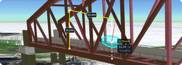
Horizontal, vertical, and slope distances
Run clearance checks in any direction, check stockpile and berm heights, and answer practical site questions directly on the map.
02
Slope area
Need the area of that wall for estimating, under that bridge for planning, or between those edges for ordering materials? This update has you covered.
03
Live readouts
Explore options and get answers while you create your measurement. No waiting for the measurement to load.
04
Precise snapping
Snap to corners, midpoints, edges, and intersections of measurements and designs, plus projected guidelines that extend from what’s already on the map.
05
Angle and distance locking
Lock your angle directly up, directly down or at certain angles from your initial point. Lock your distance by just typing it in.
06
Terrain mode when you need it
Override the new capabilities and stay clamped to the terrain whenever your workflow calls for it.
What teams are already doing with it
Real checks, real measurements, right on the map
Government
Measuring minimum clearance from the underside of beams, straight down to the roadway.
Contractors
Measuring low overhead-wire clearances from point cloud data to support traffic management planning.
Construction
Calculating the area of damaged facades and retaining walls to compile an accurate repair bill.
Mining and quarrying
Checking stockpile heights, even when tucked under bridges and roofs.
Engineering
Verifying precise differences between pipes in a survey and multiple IFC designs.
Why it matters
Measure more, with fewer workarounds
01
Fewer workarounds
Engineers, estimators, and project managers can measure anything they can see, without asking for help on every single measurement.
02
Faster checks
Live readouts mean you often get what you need without finishing the measurement.
03
More confidence
Precise snapping, in a tool you didn’t have to install, that opens any size survey alongside large, complex 3D designs.
04
One platform
Measure across terrain, point cloud, and design, without jumping out to another tool.
Roll out starts this week
Measure anything. Snap to it.
Next Gen Measurements is rolling out now.
Already a customer?
Try Next Gen Measurements
Jump into Propeller and start measuring with the upgraded tools.
Not a Propeller customer?
See how Next Gen Measurements look in Propeller
Get a closer look at how Propeller helps teams measure more on the map, with fewer workarounds.
Next Gen Measurements
Measure anything. Snap to it.
If you can see it, you can measure it. Point clouds, vertical faces, designs, and more, all with perfectly precise snapping and interactive visualizations on the map.
Previously
You’ve always been able to measure on terrain but that’s where it’s stopped.
That led to time-intensive workarounds with expensive tools, constant handoffs, and already overworked teams being asked for help on every measurement.
Now
If you can see it, you can measure it
Next Gen Measurements is the biggest upgrade to Propeller’s measurement tools, bringing together the ability to measure anything and use precision snapping to take your existing workflows to the next level.
See exactly what you’re measuring, as you measure it
Measure more on the map, more of the time
New and upgraded interactive measurements help you read your measurement live, with clearer visualizations, perfect precision, and faster answers.
01
Horizontal, vertical, and slope distances
Run clearance checks in any direction, check stockpile and berm heights, and answer practical site questions directly on the map.
02
Slope area
Need the area of that wall for estimating, under that bridge for planning, or between those edges for ordering materials? This update has you covered.
03
Live readouts
Explore options and get answers while you create your measurement. No waiting for the measurement to load.
04
Precise snapping
Snap to corners, midpoints, edges, and intersections of measurements and designs, plus projected guidelines that extend from what’s already on the map.
05
Angle and distance locking
Lock your angle directly up, directly down or at certain angles from your initial point. Lock your distance by just typing it in.
06
Terrain mode when you need it
Override the new capabilities and stay clamped to the terrain whenever your workflow calls for it.
What teams are already doing with it
Real checks, real measurements, right on the map
Government
Measuring minimum clearance from the underside of beams, straight down to the roadway.
Contractors
Measuring low overhead-wire clearances from point cloud data to support traffic management planning.
Construction
Calculating the area of damaged facades and retaining walls to compile an accurate repair bill.
Mining and quarrying
Checking stockpile heights, even when tucked under bridges and roofs.
Engineering
Verifying precise differences between pipes in a survey and multiple IFC designs.
Why it matters
Measure more, with fewer workarounds
01
Fewer workarounds
Engineers, estimators, and project managers can measure anything they can see, without asking for help on every single measurement.
02
Faster checks
Live readouts mean you often get what you need without finishing the measurement.
03
More confidence
Precise snapping, in a tool you didn’t have to install, that opens any size survey alongside large, complex 3D designs.
04
One platform
Measure across terrain, point cloud, and design, without jumping out to another tool.
Ready to try now
Measure anything. Snap to it.
Next Gen Measurements and Snapping are ready to try now.
Already a customer?
Try Next Gen Measurements out now
Jump into Propeller and start measuring with the upgraded tools.
Not a Propeller customer?
See how Next Gen Measurements look in Propeller
Get a closer look at how Propeller helps teams measure more on the map, with fewer workarounds.