Site Drainage Series (5/6)
Welcome to Part 5 of our Site Drainage Series. So far, we’ve covered:
- Rainfall simulation: Model storms before they hit
- Watershed analysis: Understand how water moves across a site
- Surface runoff: Spot runoff issues early
- Flood-to-level: See how high floodwater could rise
Today, we’re talking about the cold. Specifically, snowmelt runoff and why it’s often the most disruptive “water event” of the year for sites in the northern U.S., Canada, and northern Europe.
Who this is for: Site superintendents, project engineers, and survey managers working on cold-weather worksites.
When you use it: Two to four weeks before the typical thaw or spring restart, while you still have time to adjust your plans before the site turns into a muddy mess.
What makes snowmelt different than rain?
Snowmelt runoff acts differently than rain on-site because it:
- Arrives gradually over days or weeks
- Often runs over frozen or partially thawed ground
- Keeps surfaces wet long after precipitation ends
- Creates runoff before crews are fully mobilized
- Shows up just as teams are starting to restart work
On civil projects, that often means delays to grading and paving starts or soft subgrades that won’t dry. Low areas that looked stable in the fall might now have ponding. Haul roads turn into mush or thaw into deep ruts. At mines and quarries, meltwater means benches and working faces that won’t firm up and pit bottoms that collect water, leading to instability and safety delays.
In other words, snowmelt rarely causes one dramatic failure the way a heavy storm can. It quietly steals time from your production schedule instead, one muddy day at a time.
Snowmelt runoff, explained
Snowmelt runoff is the flow of water created when snowpack melts over time, often across frozen or partially thawed ground that can’t absorb it quickly.
It typically causes:
- Persistent ponding in low areas
- Soft subgrades and unstable access
- Sediment movement and erosion
Snowmelt planning helps you stay ahead of it by predicting where water will flow, helping you protect site access, project schedules, and environmental compliance.
Why snowmelt is a compliance risk
Spring thaw has a way of catching sites mid-transition. Controls might be sized for snow or rainfall rather than sustained melt, or positioned based on old drainage patterns from last season.
Meanwhile, inspections don’t wait for ideal conditions. Slow, persistent meltwater runoff can:
- Carry sediment toward site boundaries
- Create ponding that wasn’t accounted for
- Expose weak points in early-season erosion control
Regulators expect runoff to be managed regardless of the season. Which is exactly why proactive snowmelt planning matters.
The fix: Model runoff on your current site surface
Snowmelt analysis helps teams predict where meltwater will flow and pool on the site they’re working on today.
Snowmelt Analysis feature summary
- Problem it solves: No visibility into how melting snow will move across the site, causing erosion and avoidable compliance risk.
- What it does: Models meltwater flow paths, ponding areas, and catchments based on snowpack and thaw behavior.
- How it helps: Plan grading, drainage, and erosion control before the thaw, so spring work stays on track.
Snowmelt analysis helps you answer the question: If everything starts to thaw tomorrow, where does the water go, and where does it get stuck? That’s the difference between staying ahead of soft ground and spending two weeks playing catch-up.
4 site drainage questions Propeller helps answer:
- Where will water start moving first?
- Where will it get stuck?
- What will it touch on the way (e.g., roads, benches, controls, site boundaries)?
- What can we do to prevent downtime?
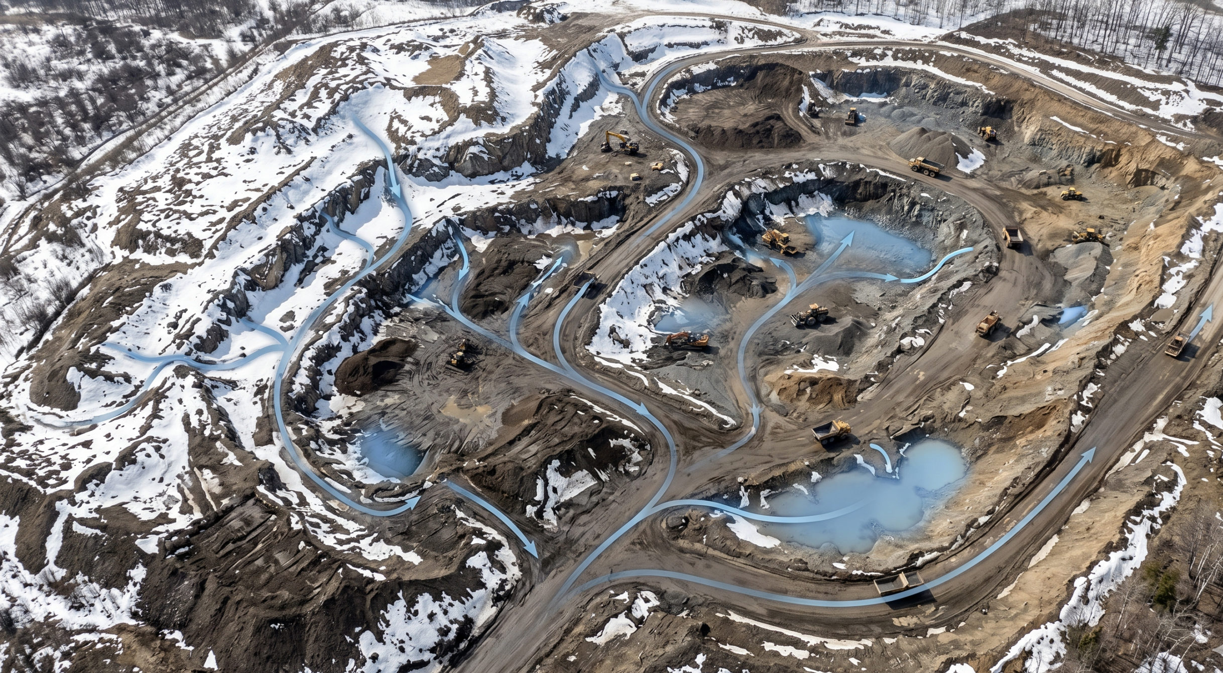
Here’s what this looks like in practice
At a quarry site in a cold climate, spring meltwater consistently drains toward the pit bottom and low traffic areas, turning access routes soft and making reactive (vs planned) dewatering a necessary evil. Using Propeller’s snowmelt analysis, the team prioritizes early grading to reestablish drainage paths and reinforces site controls before the first wave of thaw runoff hits this year. This way, they can plan dewatering activity in advance and keep production on schedule with fewer access interruptions.
If you need a fully calibrated hydraulic model (including soil types, infiltration rates, absorption, etc.), you’ll need a specialized hydraulic model. Propeller’s hydrology toolkit is for fast operational planning on the site map your team is already using, so you can make grading and control decisions proactively.
How snowmelt fits into the full hydrology toolkit
Even though it’s coming last in this series, you can think of snowmelt as Chapter One of the annual water story.
- Snowmelt analysis shows how winter runoff will behave when the ground thaws
- Surface runoff highlights where water will accumulate and persist
- Watershed analysis confirms how water will drain as grading progresses
- Rainfall simulation models storms on recent ground conditions
- Flood-to-level identifies when low areas will become inaccessible
Together, Propeller’s hydrology toolkit makes it easy for the entire team to understand and plan for on-site water flow.
How snowmelt analysis works
- Step 1: Upload your site survey. Use a drone survey, ground topo, or LiDAR—whatever you’ve captured most recently.
- Step 2: Define snowmelt parameters. Define snowpack depth, melt rate, and thaw timing.
- Step 3: Run snowmelt analysis. Propeller calculates flow paths, ponding zones, and catchments.
- Step 4: Analyze the output. Review results in 2D and 3D to see where meltwater concentrates and lingers, so you can proactively adjust grading, add temporary drainage, and reinforce controls.
Survey manager and engineering playbook: What teams do with the output
- Flag likely ponding zones for the superintendent before work starts
- Recommend temporary swales or ditch cleanouts to keep haul routes open
- Prioritize early-season surface grades to restore drainage paths
- Identify where controls need reinforcement before inspections ramp up
- Set expectations about where work can happen and where plans should be changed
Frequently asked questions
How does snow affect construction?
Snow affects construction by limiting access and weakening ground conditions. It can block or restrict haul roads and work zones, reduce operator visibility, and create safety risks like ice or unstable ground during thaw. Once snow compacts or melts and refreezes, it can also weaken subgrades and make stable, spec-ready surfaces hard to achieve, pushing projects off schedule.
What problems does snowmelt cause on a worksite?
Snowmelt causes worksite issues with sustained runoff that keeps surfaces wet long after the snow stops falling. Common issues include:
- Ponding in low areas
- Soft or unstable ground
- Erosion and sediment movement before controls are reset
- Overtopped ditches or plugged culverts
- Water collecting in excavations or around equipment pads
How does weather affect mining operations?
Weather affects mining operations by changing safety conditions, access reliability, and productivity on-site. Rain and snowmelt can destabilize haul roads and working surfaces, reduce equipment efficiency, and drive high water management demands, such as ditch maintenance, pumping, dewatering, etc. High winds and low visibility can also pause operations.
What happens when you plan before the thaw
When site teams bring hydrology insights into their spring work planning, the downstream impact (pun intended) looks like this:
- Earlier, more reliable project starts
- Fewer weather-related delays in spring
- Reduced early-season erosion
- Stronger runoff control from day one
- Smoother transition from winter to active construction


