AI runs on civil proof

Read Time: 5 mins
Quick links
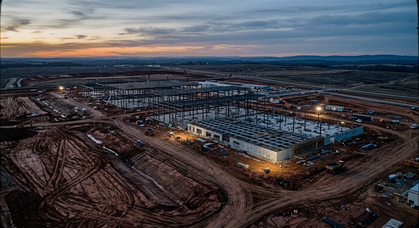
    Aerial view of an active data center construction site at dusk, with graded earth, haul tracks, and steel-frame foundations rising against a dramatic amber and steel-blue sky

    Data center AI infrastructure starts with civil construction. Propeller gives earthwork and grading teams a timestamped site record to prove pad readiness, document buried utilities, validate quantities, and keep field, office, and owner teams aligned from first capture to final handoff.

    AI may feel weightless. It lives in models, prompts, cloud platforms, and digital workflows. But before AI can run in the cloud, it has to be built in the dirt.

    Every new data center starts as a physical construction problem: land to prepare, pads to build, access roads to maintain, utilities to coordinate, drainage to manage, quantities to verify, and handoffs to keep moving under pressure. The building may be the most visible part of the project, but the first layer of progress is the sitework underneath it. On high-stakes data center projects, that civil work needs proof.

    The first layer of AI infrastructure is civil work

    Data centers are often discussed as technical assets. But they are also massive civil coordination efforts.

    The ground has to support the plan. The plan has to keep up with the field. Teams need to understand what changed, what is ready, what is blocked, and what can be handed off.

    That is especially hard on data center projects because civil work is not happening in isolation. Pads, roads, laydowns, utilities, drainage, and temporary works often overlap with aggressive schedules and shifting priorities.

    A project team may need to answer questions like:

    • Is this pad ready for the next crew?
    • Has access changed since the last update?
    • Are haul routes still workable?
    • What quantities moved this week?
    • What was installed before the trench was covered?
    • Does the current surface match design intent?
    • Which field change was approved, and why?
    • What proof supports the latest owner update?

    Those questions decide schedule, cost, trust, and risk.

    Speed is the risk on data center projects

    Data center projects carry pressure from every direction.

    Owners expect speed. GCs are coordinating multiple scopes. Civil and vertical teams need clean handoffs. Utilities, drainage, and temporary works create documentation risk. Subcontractors need defensible quantity records. Communities and regulators may scrutinize land, water, drainage, and disturbance.

    A mistake here costs exponentially more than on most civil projects. The sites are bigger, more subcontractors are working the same ground, and the infrastructure going in, including fiber lines, dedicated substations, and water cooling, carries a far higher cost when schedules fall out of alignment across that many crews.

    The dirt never sits still, either. On sites this size, material gets moved twice, three times, even four times. Every extra move is cost the sub absorbs with no chance of recouping it.

    When the site record is weak, those misses compound:

    A missed pad issue becomes a handoff problem.

    An undocumented utility corridor becomes a future coordination problem.

    A vague quantity record becomes a pay app problem.

    A design change with no decision trail becomes a dispute problem.

    A subjective owner update becomes a confidence problem.

    The work may have happened correctly. But if the team cannot prove it, the project is exposed.

    That is why civil documentation matters so much on fast-moving data center builds. The best proof is built into the workflow while the work is happening, before anyone needs it. See how contractors use timestamped site data to resolve disputes and protect margins.
    Visuals run the day, proof protects the project

    On most data center sites, the visuals alone do real work. Daily coordination between the GC and subs runs on the latest flight: who is where, what moved, what is in the way. That visibility keeps crews coordinated and the schedule moving.

    But seeing the site is the starting point, not the finish. The same record also needs to hold up when the harder questions come.

    A photo can show that work happened. A stronger site record can show what changed, how much moved, where the surface differs from design, what was installed before backfill, and what decision was made from current conditions.

    That difference matters when teams need to answer:

    • Is the pad actually ready?
    • What quantities changed?
    • What was installed before it was covered?
    • What does the current surface show?
    • What changed since the last owner update?
    • Which fix is workable?
    • What proof supports the decision?

    The daily visuals keep the work moving. What protects it is the measurable record behind them: one the whole team can compare, share, and defend.

    Propeller as the civil proof layer

    Propeller helps contractors create the site proof behind data center civil execution.

    It connects the workflow from capture to decision-making:

    01

    Capture

    Drone survey, DJI Dock, 360 walkthroughs, handheld scanning, and AeroPoints create a current record of site conditions

    02

    Coordinate

    Daily and weekly coordination meetings run on Propeller. Utility, earthwork, and concrete crews work from the same latest flight or progress report, so clashes between trades get caught before they cost schedule

    03

    Measure

    Site analysis, surfaces, cut/fill, stockpiles, and quantities validate progress and work-in-place. DirtMate RTK adds machine-level proof: as-built verification without waiting on survey data, in-cab grade guidance, and automated cycle counts and utilization data from every machine on site

    04

    Compare

    Design surfaces and linework overlaid on the current map show exactly where the site matches the plan and where it does not. With Propeller CAD, teams can sketch a fix in plain language, drawing a pad, haul road, trench, or drainage concept on real survey terrain in minutes

    05

    Decide

    Rough quantities for each option, clear tradeoffs between cost, time, and material movement, and clean field-to-office handoffs move teams from “what happened?” to “what do we do next?”

    06

    Share

    Reports, timeline, owner-ready updates, and shared views give project teams, JV partners, owners, and VDC teams one record they can trust

    Propeller helps teams prove readiness, quantities, utilities, drainage, and the decisions made from current conditions, all from one shared site record.

    What civil proof looks like in practice

    Civil proof is the difference between saying a pad is ready and showing the current surface measured against the design surface in Propeller; between reporting progress and backing that update with a dated drone survey and progress report; between trying to remember what happened before backfill and pulling up the 360 walkthrough or handheld scan captured before the trench was covered; between arguing over quantities and pointing to the cut/fill measurement history for that exact area, backed by DirtMate RTK machine data; and between a field decision living in a screenshot and a decision trail annotated on the shared site map, tied to current conditions.

    For data center teams, that proof can support:

    01

    Pad readiness

    The as-built surface checked against design, verified by DirtMate RTK without waiting on survey data

    02

    Civil-to-vertical handoffs

    A dated record of site conditions at the moment of handoff. See the 7 civil checkpoints that matter most on data center builds.

    03

    Utility documentation before backfill

    360 walkthroughs and handheld scans of open trenches and corridors

    04

    Drainage and disturbance records

    Surface comparisons across flights over the life of the project

    05

    Quantity validation and pay apps

    Cut/fill and stockpile measurements backed by DirtMate cycle counts

    06

    Design change conversations

    Revised design linework overlaid on current site conditions with Propeller CAD

    07

    Owner and JV partner updates

    Owner-ready reports generated from the same record the field uses

    08

    Dispute prevention and resolution

    A timestamped history of what was done, where, and when

    09

    Field-to-office coordination

    One current map everyone works from

    The goal is to make the work teams already manage easier to verify, share, and defend, without adding reporting work.

    AI runs on infrastructure.

    Infrastructure runs on civil execution.

    And civil execution runs on proof.

    As data center construction accelerates, the teams best positioned to keep projects moving will be the ones that can prove what changed, what moved, what is ready, what was handed off, and what decision comes next.

    Propeller helps contractors create that proof from the ground up.

    Quick links

      Related articles

      Track and Share Safety Hazards with 3D Drone-Powered Site Maps

      With new tools like RTK-enabled drones for surveying, capturing site data is becoming easier and…

      Inside Propeller #4: How estimators keep jobs profitable from day one

      Inside Propeller: How estimators build reality-checked bids (4/6) Welcome to Part 4 of our Inside…
      Aerial view of an active earthwork site at late afternoon, showing an open trench, covered stockpile shed, and a drone overhead casting a shadow on graded soil

      Handheld scanning: Everything you need to know

      Propeller’s handheld scanning lets site teams capture feature-level 3D data between drone flights, documenting trenches…

      Ready to learn how Propeller can power up your worksite?

      We’re happy to show you how Propeller can power your worksite, and boost productivity.

      Related articles

      Drone pilot in hi-vis flying a drone next to a crane, with an AeroPoint on the floor.

      Things To Know About Ground Control in Drone Surveying

      Ground control is the go-to option for turning drone data into highly accurate, survey-grade models.…
      DJI M4E flying in the sky

      Propeller’s Drone Guide: DJI Solutions for Commercial Operations

      At Propeller we love testing new drone hardware and we are processing hundreds of drone…

      Telecom Tower Inspection using DJI Phantom 4 Pro: Step-by-Step Guide

      A few weeks ago a new DJI Phantom 4 Pro was delivered to our office.…